Showing posts with label hiking. Show all posts

Wednesday, September 3, 2025

Day 5 - GC17

Continuing on with my story of August 2024 road trip to Oregon, I next set my sights on finding GC17 and also GC12.  GC17 was the top order of the day, having been hidden in June 2000.  Finding this cache would complete my Jasmer Challenge (finding a cache hidden in every month since geocaching had been around). GC12 was the oldest geocache hidden in the entire state of Oregon. It was hidden in May of 2000, a month that I'd already completed by finding the oldest cache in Kansas. Still it would be helpful for other challenges that I was currently working on as I continue geocaching in the coming years.

As with the other caches in this area, I had good intelligence as to where to park for quick access to this particular cache. If you asked me how I got there, I'd answer Google Maps.  I just put the coordinates in for the parking area and said pretty much, "lead the way Google." It was a Sunday morning, so traffic was fairly light, but once I got close to the area, the roads became more winding and there were lots of areas where there were plenty of cars already parked. I thought there were going to be a lot of hikers out here.  Boy, was I wrong about that.

Getting to the parking coordinates for GC17, there was only one other car there and it was more of a wide spot in the road, so I found a convenient spot to pull over and gather my stuff together for the quarter mile hike up to the cache. As soon as I got out of my car, I was met by a couple of very aggressive dogs from the other car who just happened to be coming down the trail. The guy told me it would probably be better if I got back into my car and wait until his dogs were back in their car. Seriously?  Leash your dogs up if they are that aggressive. But I digress.

Once the dogs were safely in their car, I got out and left them behind and started my hike up to the geocache. The first thing I noticed was the trail head was littered with thousands of used shotgun shells and old targets of various sizes. I could also hear gunfire in the distance, but at least there was no one here shooting, so that was a good thing. Eventually, I left the sounds of shotguns being fired behind and had the trail all to myself. It had rained the previous day and the trail was very narrow, so I was very glad I'd brought my rain jacket along with me as it kept me fairly dry as I walked up the hill. The first photo was at a wider area of the trail. There were literally times when I was brushing against the bushes on both sides of the trail as I steadily climbed the hill.

Eventually, the trail opened up and I could see from my GPS unit that I was getting close to the cache. I should have stayed on the trail, but I decided to take a more straight line approach to where the GPS unit was saying the cache was. Once I got over there, I saw that I was now standing on another trail that came down from a ridge just above, something that I would have noticed had I just stayed on the original trail and made my way up to the ridge. Geocachers are like that.  Straight line usually means bushwhacking and if you're patient, you'll usually find another trail that will take you there. Was I patient? Of course not. 

Eventually I spotted the cache and opened it up. I got the log book out and signed in, having now completed my Jasmer Challenge. I decided to leave a travel bug in the cache so that some other geocacher who came after me would pick up and move along. I took my photo at the cache then re-hid the cache and hiked up to the top of the ridge. The entire ridge was covered in fog, so I didn't really know what I was missing up there, but had the ridge been clear, I would have had spectacular views of Mt. Hood. And yes, I know the photo looks like it's starting to clear, but the entire area where Mt. Hood was, was filled with fog. At that point, I decided to take the trail back down to the car and move it over to where I would be hiking up to the oldest cache in Oregon.

Unfortunately, when I got over to where I would be starting the second hike, there were shooters there, firing out where I would be hiking.  I decided to pass on the oldest one. I figured I'll be back there sometime in the next couple of years. I suspect that going to that one on a weekday, there'll be less of a likelihood of shooters since most of them are probably working during the week to pay for all of the ammunition that they used up on the weekends. I spent the rest of my day geocaching around the city of Portland. I would be leaving the next morning and heading south into eastern Oregon for my geocaching adventures.


Monday, May 19, 2025

Creating some balance

The past 6 months or so, I've been doing a lot of geocaching. And when I say a lot, I mean a lot. So much so that it feels like other aspects of my life have gotten shortchanged, particularly hiking. I would go out to find some geocaches, but not get in a decent hike, even though the trails might be right there. That wasn't helping my psyche in the least, so today, I didn't go geocaching and just decided to hike the Claremont Wilderness Park loop trail.

Surprisingly, I feel pretty good afterwards although my left foot is a little sore. I made sure to take frequent water breaks and not try to overdo it by really crunching out the miles in record time. According to my Garmin inReach, I still averaged 2.4 miles per hour over the course of the 5+ mile loop that I took today, including the little side trip down a spur trail to check up on one of my geocaches. That's the little point you can see on the map at the top.

Unfortunately, it appears as if that one has gone missing, so I decided to archive it today. I'm not sure how that one could have just disappeared, but the log that it was hiding underneath wasn't there anymore, so perhaps some trail maintenance personnel found it and through it in the trash thinking it was garbage. Perhaps someone else will hike up there and place something, but in all likelihood, I'll probably take another hike up there in the near future and hide something new.

It felt really good to be back out on the trail and I just need to remind myself that I need more of that balance between different activities in my life. Now, I guess I need to find another trail to go hiking on sometime soon.

Wednesday, May 8, 2024

Point of View

It's time, once again, for PJ's photo blogging challenge. The challenge for the month of April was "Point of View." Now, I think this can be interpreted in a variety of ways, so here's what I came up with for last month.

Bracket Field

I live near a large regional park and last month I took advantage of the free parking in the off season on weekdays to do several hikes in the park. The one large hike that I did last month took me around the perimeter of the park, slightly over 9 miles all told. The trail is mostly a fire road, so it's wide, but it does take us into some interesting areas. There is a small airport (Bracket Field) along the northeast corner of the park and I got to see several small private planes take off as I walked along the trail. Not much you can really do with this point of view other than to take the underside of the plane. Interestingly, it's also the only shot of the five that I've chosen that isn't predominantly brown, so I have that point of view going for me as well.

Ground level

Early in the hike, I almost stumbled upon a garden snail. I found this particular animal kind of intriguing, mainly because normally, when I see these kinds of snails, they're usually found in a fairly wet environment. Not so for this guy as he was in the middle of a pretty dry trail. Although, I will admit that the year so far has been one of the wettest we've had on record, which could be the reason this snail was so exposed. Either way, I decided to get down as close to ground level to get a good up close and personal shot of the snail as it traveled along its way, heading for the other side of the trail.

Many times, I'll try to encourage snakes to get out of the trail and I even moved a tortoise we found in the middle of a dirt road off of the road so it wouldn't become road kill later on, but for some reason I didn't do this with the snail. Not sure why outside of the fact that it is not a native species to the area. Still, from its point of view, it probably has only known that one area where it has called home. I guess I should keep that in mind for the next time as I did encounter several bicyclists on the trail and kept wondering, did they miss this guy as he made it across the road? Who knows? But at least I can help it along if I encounter other animals in the middle of the trail, especially the slow moving ones.

Animals from a different point of view

As noted above, we've had a lot of rain since the beginning of the year. For comparison sake, we average in my area about 13 inches of rain per year, which is why we're classified as a semi-desert. Last year (January to December), we received slightly over 35 inches of rain. This year, we've already received over 23 inches of rain since January 1st. Granted we are moving into the dry season in Southern California, but most people who know our climate or have lived here for awhile know that's a lot of rain for our area.

But because of this, we get a different point of view of some animals that we don't see very often. If you've been paying attention, you know that I love animal encounters and will go out of my way to photograph animals in the wild. Very rarely do I get to encounter deer in our local foothills. I didn't see the deer that made these prints, but because of all the rain, I did get a decent shot. I'm sure these prints are no longer up there on that particular trail due to other foot and bicycle traffic, but from my point of view, it will always be there.

Desert tortoise

On the last weekend of the month, a friend of mine and I went up into the desert to do some geocaching. As we were traversing down this dusty one and a half car width dirt road, we came over this rise and I saw this big California desert tortoise in the roadway. Fortunately, my friend who was driving, was able to stop in plenty of time. These tortoises are endangered species and are protected over their range, which we were obviously in at the time. One of the things that you're not supposed to do is disturb them. That being said you do have permission to move the animal off of a roadway for its own protection. You're supposed to move it to the side of the road, in the direction that it was heading.

So we got out of the car and I gently lifted the tortoise off the roadway and off over the bank into this area where it was heading. I wanted to be as gentle as possible since if they feel like they're being threatened, they will sometimes void their bladder in an act of self defense. This isn't a good thing for the tortoise since now it doesn't have its natural water reserve. Fortunately, it didn't do that and as I moved it, I also checked to see if it was a male or female. The curved underbody of the shell told me it was a male and a good sized one at that. If you look closely at the hind legs, you'll see nice long claws which are used for digging burrows in the ground. Those are about a quarter inch in length and from the front of its shell to the back, it was about 14 inches in length. This was also the first time I've ever encountered a desert tortoise in the wild, so I had that going for me as well.

Different camera

For the first time in awhile, I got my Canon DSLR camera out of its bag and took it on a hike later in the month. It had been about 2 and a half years since I last used the camera and I felt it was high time I got it out, dusted it off and use it again. I had posted about this on Facebook previously, but the reason for not using it were a variety of things. I hadn't been satisfied with the way it was dealing with different kinds of light, especially harsh midday light and on one of my road trips, I just didn't use it and relied solely on my phone for photos. I've been happy with the results of what I've been taking recently with my phone, but from my point of view, it was limited, especially when it came to taking wildlife photos.

That came to a head a couple of days before I got this shot of a gopher snake, when I spotted a couple of coyotes in a field. I got a decent video with the phone, but couldn't get a really good close up shot. After I got home, I got the camera out, put it through some paces and then took it out on a hike where I got this shot of a gopher snake "tasting" its surroundings. So I guess what I'm saying here is depending upon the point of view I want to convey will probably determine which camera I use. I'm not going to confine myself to one particular lens anymore.

And there you have it, my take on the Point of View challenge for this month. Please stop by PJ's page to see how others did this challenge. Please feel free to comment here.


Sunday, April 28, 2024

Bonelli Park Hike

About a week and a half ago I decided to hike the perimeter of Bonelli Park, a regional park located in my area. I decided to take advantage of the nice weather and the fact that there's free parking on the weekdays until the end of April there. There are several different trails that could have lured me in and I've hiked many of them in the past, but I decided to take the main trail around the park, the Bonelli Trail. I'd never hike the entire trail before, so some of this was going to be brand new to me. This particular trail follows fire roads around the edges of the park and sometimes the "communing with nature" is just a myth since the park borders on two major freeways in our area, Interstate 10 running east/west and Hwy 57 which runs north/south. But it was an enjoyable hike nonetheless.

I found a place to park the car down by the picnic area mainly because the trail comes very close to that point and then I started my hike there. It was here that I made my first mistake, but I really didn't think much of it until later in the day. I started out heading in a counter-clockwise direction on the trail, got about 100 yards up the trail when I realized that I hadn't turned on my Relive App on my phone. I wanted to record the entire hike as I traversed around the park. So I walked back down to the trailhead, started up the app and then decided to hike the other way along the trail in a clockwise direction around the park.

The trail from that point works its way over to the west entrance of the park and parallels Hwy 57 for a good distance. But as you can see from the first photo, there's a lot of cool, green and shady spots along the trail. In fact, most of the trail on the western side and the northern side have a lot of spots where you're hiking in the shade of large trees. You also have to be aware of poison oak as well. If you look at the bridge, the bushes growing through on the right side and then again on the left side at the other end of the bridge are all poison oak. It's not something that you'd want to bump into, but as I was walking by, I could tell that numerous bike riders had done just that, based upon some broken branches along the edges of poison oak that encroached on the trail.

On a side note, my back yard rain gauge has measured out over 23 inches of rain since January 1st of this year. Since we average 13 inches or so for an entire year, the lake that lies in the center of the park is very full. I crossed over the spillway for the dam and while no water was flowing at that time, you could tell, just by the dampness in the area that they appeared to be periodically spilling water as the snow melts in the mountains.

Needless to say, there was a lot of muddy areas of the trail, but once I got over on the east side and started heading south on the trail, it dried up considerably with the exception of this one area where I was forced to wade across this water inlet. I took my shoes and socks off and carefully waded in. The water came up almost to my knees, but it was actually rather refreshing. Getting to the other side, I put my socks and shoes back on, had a snack and then continued on with my hike.

The last several miles of the hike, which headed south and then west back to the trailhead where I started were on exposed ridges and/or low lying area with little any shelter from the sun. When I mentioned my mistake before, this was it. Had I done the hike in a counter-clockwise direction, I would have been through this part of the hike early in the day, when the sun is usually very welcome. However, later in the day, it just beat down on me and sapped my strength so my pace was much slower than usual. 

No rattlesnakes were spotted on the hike that day, although it appeared as if the weather was perfect for snakes to be out basking. I did encounter a very large gopher snake just relaxing at the side of the trail. It let me get quite close to it for a photo op and never did try to flee. I also saw a coyote ambling down the trail earlier in the hike, but just briefly, so I wasn't able to get a shot of it before it ambled off the trail and into the underbrush.

Overall, the hike was 9.1 miles with 1276 feet of elevation gain. It took me 3 and a half hours to traverse. That's a decent 2.5 miles per hour for the entire trek. I did end up stopping once for a maintenance check on one of my geocaches hidden in the park, but that probably added only about 5 extra minutes on to the entire hike. It was a good workout and one that I will probably do again, although not until the fall because the weather is heating up and it's harder to hike when it's really hot. And so it goes.

Friday, November 17, 2023

Lizards and Spiders and Snakes! Oh My!

Today I went out on a hike and missed seeing the trifecta in my title by about 50 feet or so. I hiked the Claremont Hills Wilderness Park loop today, a little over 6 miles from my car back to my car. I decided today was a good day for a hike, since it's supposed to rain again later in the evening and on into tomorrow. We got rain on Wednesday, so the trail had dried out enough that footing wasn't an issue, but it was still damp in spots where you could make out deer tracks.

I think I got on the trail right around 9:30 or so. Being as it's sunny, but cool, it seemed like a perfect time for me to go hiking when most of the morning crowd have already left the park. Less people means there's a likelihood of seeing more animals out and about and I was able to spot all sorts of interesting things.

For one thing, there were still quite a few butterflies flitting about. I saw one tiger swallowtail and at least two different cabbage white butterflies. I saw several lizards running away from me along the trail or disappearing into the brush as the side of the trail. Lizards are interesting creatures in that they'll hold still for a very long time and then all of a sudden will make a mad dash. I think in reality if they were to hold still and just stay there, many people would miss them altogether. I, for one, have noticed many lizards only after they started moving away from me. They tend to blend in a little better into the dirt and stuff of the trail than do snakes, so I feel that they're not as easily spotted as are snakes.

The main attraction along the trail today however were the tarantulas. For the most part, this is about the only time of the year when you can really see tarantulas out and about. It's mating season and they're out prowling around for mates. This guy was about halfway across the trail/fire road when I encountered it. I took quite a few shots of it, but several of them came out blurry. I guess I'm still getting used to the camera on my new phone, but I got several good shots, this one being the best of the bunch. After taking this shot, I got back up and let the spider walk between my legs and continue to the other side of the trail.

Later on I encountered another tarantula walking along the side of the trail. I watched it for a little bit, even putting my shoe out in front of it to see if it would climb over my shoe. It touched my shoe with one foot and then decided to detour around it. Oh well, I tried. And I can already hear some of my friends and family thinking, "Geez Paul, why do you do some of the things you do?" Because I'm interested in things like that. Anyway, I left that tarantula alone, continued on my hike, but just around the corner, a maintenance truck was coming down the trail and so I became worried that it might run over the tarantula, so I walked back down and was relieved to see that it missed it by at least a foot or so.

I didn't see any snakes today, however as I noted above, it appears as if I missed seeing a rattlesnake by about fifty feet or so. I was on the downhill stretch of the trail, heading back to the car, but I still had about a mile and a half of walking to do when a guy came jogging up the hill. Instead of the normal wave or quick hi, he said, "There's a rattlesnake on trail." My response back to him was "Cool." He said it was about fifty feet further down the trail, so I walked down, but unfortunately (at least for me), I never spotted the snake, which means it had probably already slithered off into the brush along the side of the trail. No photo of a rattlesnake today, so you'll have to be satisfied with this photo of the gopher snake I spotted a couple of days ago along another part of the trail.

All in all, it was a good hike and workout today. I feel like I'm back to my old self once again and I even thought about hiking the loop a second time, but I knew that probably wouldn't be good for me since I could feel myself getting hungry. Another two hours on the trail without any kind of sustenance would not make a happy me. But the good thing was that my energy level seems to be back the way it was before all this health shenanigans started almost a year ago. The only thing that I have noticed is the my mileage times aren't quite there and I'm not sure they ever will be. I used to be able to do that loop averaging about 18 minute miles. Today, I averaged slightly over 20 minutes per mile, which I find acceptable. I'm getting older and it doesn't make sense to punish my body for the sake of fast miles. The whole purpose is to get some exercise and enjoy the scenery. I did both today.


Wednesday, November 8, 2023

Be Ever Vigilant


Every now and then we all make mistakes. Today, while out hiking, I was doing my usual thing, scanning the trail when I heard something off to my right, so I looked over there to see if I could see anything of interest. The problem with what I did is I usually stop and look. This time I didn't, but kept walking up the trail. And that's when everything went kind of sideways.

I turned my head back to the trail, took one more step and out of my peripheral vision, I saw something move right about where I was going to place my foot. This little guy now had my complete attention and apparently I had its complete attention too as it immediately coiled into strike position. And it's amazing how many thoughts went through my head in probably the one second or so it took to push off with my other foot and take an exaggerated jump over this snake.

Thought one, "Oh crap, I'm stepping on a baby rattlesnake."

Thought two, "Why isn't it rattling? Too small to have an active rattle?"

Thought three, "Where's its damn tail, oh there it is. Oh, it's a gopher snake."

As you can see from the photo, I really got way too close to this one. That's the first time I've ever seen a gopher snake go into strike mode. It was prepared to defend itself and it didn't really believe that I was friendly and wouldn't hurt it on purpose. And as you can see it remained in a semi-strike mode even after it took off into the bushes at the side of the trail.

The lesson is, if you hear a sound off trail, stop, look and listen. Then continue on with your hike. Had I done that, this encounter probably wouldn't have been less stressful for both of us. Also, be ever vigilant, even in the cooler months as they still could be active.

Thursday, August 31, 2023

Happy Place

It's the end of the month which means it's time for P.J.'s monthly photo blog challenge. I thought about this one, then figured that I have a bunch of happy places, things or actual places that I enjoy immensely, so I thought I could make this more about all of my happy places as opposed to just one happy place. I mean, why limit yourself? And I'm sure if I really tried, I could come up with some more, but these are the ones I've chosen for this month's photos and they are in no particular order of importance.

1. It's all about planning

Right now, I'm in the middle of my second round of immunotherapy for my cancer treatment. This is a maintenance round, primarily meant for preventive care, so that's a very good thing. I had my first treatment on Monday and I have two subsequent treatments on the 5th and 12th of next month and then it appears I'll get another 3 month break. What this means in the long run is I'm planning a road trip to Utah and Colorado.

One of the things that has been really frustrating about my illness is it's not really allowed me to plan any kind of trips because I've had appointments, surgeries, and procedures that have take top priority. I get that, but with more free time, I've been able to start planning for future trips again.

I love planning road trips. I love to look at maps and guidebooks and determine what route I will take in order to fully maximize the time I have for this specific trip. This time, the plan is to head to Grand Junction, Colorado and tour Colorado National Monument and Black Canyon of the Gunnison National Park

I've been to Black Canyon of the Gunnison way back when I was around 13. This was actually so far in the past, the park was a national monument at the time and has since been upgraded to national park status by an act of Congress. I've never been to Colorado National Monument, but I intend to spend a day at each park and make Grand Junction my base for the three days and two nights I'm in the region. 

And I will be the first to admit that I started planning this road trip too early. I've pretty much set up my itinerary, have my hotels books and know what I want to do each day and I WANT TO GO NOW! But I can't, because of my upcoming treatments. I should have waited until next week perhaps to start planning, but you'll see later in this post that waiting might not have been a really wise choice either, because next week is going to get busy.

2. Papa and Gaga time

We didn't do this very often last year, but once I got sick, time became a little bit more precious and my daughter and son-in-law started having regular video chats with us so we could see the little one. Usually these happen around dinner time, so in essence we get to eat dinner with our granddaughter on an almost daily basis and we live 300+ miles away from each other. This is just one of the many screenshots I grabbed a couple of weeks ago when we were having dinner together.

Just watching and listening to her babble about her day, what's she's eating, her insistence on seeing our two Pooh bears that she knows are at our house, and seeing her new developments that seemingly happen on a daily basis really takes me to a happy place.

I've heard it said that being a grandparent is the best and I've probably said this more than once on this platform, but it really is. And she's coming to visit in about a week. It will be a short visit, but we are both really looking forward to seeing her and her parents.

3. The Wonders of Nature

I will never be not astounded by the wonders of nature around us. It's probably why I love to travel, to experience new things in nature to me. It also allows me to practice my art of photography and although that's developed and evolved over the years, especially with my reliance more and more with my phone as opposed to my DSLR, I still love going out and hunting down that elusive butterfly, or taking a wonderful landscape photo from some place I've visited. This particular butterfly allowed me to get my phone about two inches away from it, almost as if it knew I wasn't going to try and capture it.

My parents instilled in me a love of nature and I fully want to enjoy it for as long as I possibly can. Already in my mind, I'm planning other trips that I can take in the future. 

4. Hiking

I realize this photo isn't the greatest photo, but it really encapsulates what I enjoy about getting out in nature. I've been asked why I never took up mountain biking as it appears as if I'd be a good candidate for that particular type of exercise and recreation and I think it's mainly because I feel that biking would intrude in some of the other happy places I also like to enjoy, like photography, nature and geocaching. I mean, if you're flying by something at 20 miles per hour, by the time you stop to "smell the roses" or pursue the butterfly, the butterfly has already flown away. And so I walk, and I walk, and I walk.

Before I was retired, I was pretty much limited to hiking on the weekends. Now, I just get up, look outside and if the day looks promising, I'll put on my hiking shoes and head out to a favorite trail and enjoy the day. And what's really funny about all this is, as a school teacher, we're used to loving our summers. Now, I would honestly say that summer is my least favorite season of all. It's so dang hot that unless you get up at the crack of dawn and get out on the trail, it's usually pretty miserable out there. It's so much nicer during the cooler months of fall, winter and spring, when you can go out just about any time of the day and get a good hike in without feeling like you've been on a summer death march. Plus, now that I'm retired, I can hike any day of the week, so I don't have to exclusively go on the weekends when the trails are crowded. Nice quiet trails where I can really enjoy nature take me to a happy place.

5. Geocaching

Did you really think I could get through an entire blog post talking about happy places and not talk, at least a little bit, about geocaching? I didn't think so.

So much of the past 22 years of my life has been intertwined by this silly game that I discovered. As one of my friends, who I later introduced to this game said, "Geocaching. It's hiking with a purpose!" Although I'm not sure I agree with this sentiment entirely, I did see where he was coming from with his explanation.

And yes, part of my next roadtrip will be geocaching related. I'm actually planning on hosting two event caches while out on the trip, one in Grand Junction, Colorado and another one in Salt Lake City, Utah. What better way to meet up with other geocachers in the area than by attending an event. I looked at my itinerary and then searched to see if there were already events planned (there weren't), so I decided to host my own morning coffee events. I usually do this when I'm on a road trip, but this is the first time I've hosted two events while out on a trip. It's kind of ambitious for a 7 day trip, but I'm up to the task.

It's always enjoyable to talk with other geocachers about the game. Who knows, I might end up going caching with one of the people who show up at one of my events.

The other goal of this trip is to get the webcam caches that are in the Salt Lake City area. A webcam cache is where there's a public webcam that you need to stand in front of the webcam and either have a friend back home get a screen shot of you, or you can alternately get a screen shot of yourself off of your phone.

I've signed several challenge caches for finding webcams and since there are four different webcams in this area, it's like a goldmine for cachers working on webcam challenges. To put things in perspective, there are approximately 203 active webcam caches, so they are exceedingly rare. Webcams are no longer recognized as "real" geocaches, so these are the ones that have been grandfathered into the system. They are not getting replaced, so when one gets archived, it's gone and there's not going to be one to replace it. That's why when geocachers see there's a webcam close by, they want to get their photo taken, because you never know if that particular webcam might disappear sometime in the future. Of the 10 that I've taken a photo at, only 4 of them are still active.

And there you have it, my take on the theme Happy Place. Please stop by P.J.'s page and see how other people interpreted the same theme.  And as always, please leave a comment. I won't bite.


Wednesday, July 5, 2023

Where Will I Go?

Wow.  It's been over a month since my last post, which I guess in a way, that's a good thing. Most of my previous posts this year have been about my health, but since I'm feeling really good right now, it's allowed me to get out and about, which means that P.J.'s monthly photo theme of "Where Will You Go" worked really well for me. 

This past month, I was able to get two short road trips in.  One was totally geocaching related and though the wandering was just within the state of California, it gave me an idea of what my stamina might mean in the coming months should I decide to do some longer road trips out of state. The second road trip was a bit longer and it involved the granddaughter, so that's always a good thing. That trip near the end of the month was the first time we'd gone up there since my diagnosis back in December. So here's my monthly installment of the theme for this month.

1. I went where the wild things roam

A lot of my geocaching friends call me a snake whisperer. I take that as a badge of honor, but in reality, as I've noted in the past, I like to think that I'm just a little bit more observant around reptiles, especially snakes. I know of three people in my geocaching world who've been bitten by rattlesnakes and I don't want to become part of the club.

This being said, I found this guy crawling across the road that lead up to an old cemetery where I'd found a geocache. 5 minutes previously, he hadn't been there, but was halfway across the road when I came back down the hill from the cemetery. So naturally, I got out of my car, walked over and took several photos while it continued on its way across the road. I did that for two reasons, one of which was to obviously get some photos, and secondly to make sure that it got across the road without being run over by anyone coming up the road. Once it disappeared into the brush at the side of the road, I hopped back into the car and continued on my way.

2. I went where there are some "interesting" things to see

I've noted this several times in the past, but geocaching has taken me to spots that I would have just ignored previously. I'm not saying that Gum Alley was a prime tourist attraction, but it was quite different and something that I wouldn't have even known about were it not for geocaching, so that in itself is a good reason for me to continue this silly game I play.

I walked back and forth down the alley and was followed by another family of four. The older boy (about 5 or 6) had it right off the bat when I heard him whisper to his mom who was busily trying to keep younger brother from touching anything, "This is disgusting!" And yet people keep coming to sites like this, not only here in Atascadero, CA, but also other places around the world. I guess disgust breeds a kind of fascination.

3. I went into a child's imagination

My granddaughter is walking and talking and has a very vivid imagination. Her breakfast smoothies she makes have quite the list of ingredients and of course she expects you to eat them. This was the first time we were able to see her up there at her house since Christmas time and since there were other geocaching related things happening up in the Bay Area at the same time, I was able to kill two birds with one stone. It was a very fun trip and I wish we'd been able to stay longer, but we had a short window of time sandwiched between optometry appointments and dentist appointments. Fortunately, they're coming down here twice in the next couple of months so I'll still be able to get my Papa fix. We also FaceTime on almost a daily basis at dinner time, so I get to see her a lot. She fills my spirit.

4. I went hiking

This was so good. I like to hike a lot and with my health problems over the past half year, I haven't not been able to do that. But a couple of weeks ago, I went on a full fledged hike in the Claremont Hills Wilderness Park and hiked the loop trail which ended up being over 6 miles round trip from parking spot back to parking spot.

I was able to check up on a couple of my geocaches that were along the trail, four of which I'd noticed had problems since the last time I was up there. As it was, I ended up archiving two of them because they'd been buried by trail crews right before I wanted to get up there, but was able to confirm that two others were right where they were supposed to be. I also helped a couple other cachers out by checking up on their caches. 

When I got home, I was definitely gassed as my body was saying, "WHAT THE HELL ARE YOU DOING TO ME?" Yeah, I know, I haven't done this in a while, but it's going to feel good once we get back into the rhythm of it again. My problem is I need to start getting up earlier in the morning as summer is definitely here and if I wait until 10:00 in the morning it's way too hot to hike the loop. What I need to do is get up at 6:00, hit the trail, then have breakfast, a cup of coffee and a shower afterwards. Yeah that's the ticket.

5. I went geocaching with 300 of my closest friends

Well, that's definitely an exaggeration, but I did attend a geocaching Mega Event up in the Bay Area when we were up visiting the granddaughter. For those of you who aren't geocachers, we have events all over the place. I host a monthly coffee event on the first Saturday of the month in my local area, usually drawing between 10 to 25 people. A Mega Event draws over 300 people! 

This was held in an historical park in San Jose, CA and geocachers from all over the country and possibly other countries as well converged here the last Saturday of June. There were all sorts of gadget caches (caches that are more difficult to open to sign the logbook) that we could work on at the event. The historical park gave us lots of interesting things to explore, plus there was a nice hiking trail that took us around the park to other newer geocaches that published that same day. This was the 6th Mega Event I've attended and it was a very enjoyable event. I look forward to my next event, probably next February in Yuma, AZ. 

When I go out geocaching, I always take my green ball point pen with me to sign the log in the geocache. Looking at the photo, I think I need to invest in a couple of green Sharpies so my name shows up better on the log sheet for Mega Events.

Well, there you have it, my interpretation of the theme "Where Will You Go?" Feel free to check out P.J.'s blog for his interpretation. There are links down at the bottom of that page to other people's interpretations as well. Feel free to leave your comments down below. I try to respond to all of them. Thanks for reading along.

Monday, May 15, 2023

Nicer Weather means Hiking and Geocaching.

This post is about geocaching, so if you're not into that, feel free to leave.  I won't be offended. 

Today, I went on a short hike today to test my stamina and also to scout out a spot for a hide that I've been working on. It was a short hike, but the views were worth the effort as seen by the shot I took from the trail.

One of my goals is to hide quality hides and to hide approximately 2 per month. For obvious health reasons plus weather related issues, I've only been able to hide 6 caches this calendar year, but now that the weather is better and my health is improved I can get back out and hide some more caches. Today was a start.

I found a spot that has a fairly nice view and with the type of camouflage I felt I did a pretty good job of hiding this one in plain sight. I haven't submitted it yet mainly because I want to hike back up there again to test the coordinates and to work on my stamina. Today, I walked about 500 feet further uphill before I turned around and headed back down for the day. I don't want to over do it on the first foray back into hiking.

So tomorrow, I'll head back up there to test the coordinates and see if I can get further up the hill. Oh, and as a public service announcement for those of you hitting the trail - be on the look out. I saw lizards today and unfortunately I found a two and a half foot dead rattlesnake. I much prefer the live variety to the dead one and I know some of you think I'm weird that way, but I'd much rather prefer a snake over any kind of rodent. Needless to say I was a little sad to see this guy at the side of the trail, but he was providing sustenance for other creatures, so it's all a part of the circle of life.

Thursday, October 6, 2022

Road Trip

Well, this one is way late in coming and I should have written some other stuff in here many months ago.  But that's water under the bridge and so seven months have gone by since I've written here. It's not like I haven't been motivated, but I just never got around to it and this has languished long enough.

So why all of a sudden am I writing today?  Well, P.J.'s photo blog challenge for this past month was the theme "Road Trip" and I did go on a road trip last month where I actually took some photos, so it made it easy to get back into the swing of things.

When I retired three years ago, I set several goals that I wanted to accomplish so it wouldn't get stagnant. One was to visit or do one new thing each year. The second was to have at least one overnighter somewhere each month. It didn't necessarily have to be a camping overnighter, but just somewhere different each month.

It was going fairly well, but then the pandemic hit and everything fell apart. But recently, I'm been getting back into the swing of those goals. And I will be the first to admit, that it's easy to come up with an excuse to take off for a long road trip.  
"Honey, I'm going up to visit the grand baby."  And so I go, although both of us went up in April for Easter, but I went up by myself to visit her in July.  June, I did a road trip up the Owens Valley on the east side of the Sierra for a lot of really good geocaching.  July, the grand baby came down here for three weeks and then we turned around and went up there for another week. Why? Because we could. August, I did another short backpacking trip in the Sierra and that brings us to this month.

I looked at the calendar and the weather forecast and it was going to be hot down here, so I decided to head up to visit the grand baby again, then head up to Lassen Volcanic National Park. I've visited this park many times in the past and seven years ago I accomplished a bucket list item by summiting Mt. Lassen in June 2015. So why go back? It's one of the least visited national parks in the lower 48 states, so there's a lot of peace and quiet, especially if you go during the week. My plan was taking me there on a Tuesday and leaving on a Friday before the weekend crowds come in. Second, because it was already mid-September, the crowds were going to be even smaller during the week, because school is back in session so there wouldn't be as many vacationers out.

Third, it's a beautiful park with some fascinating geology, plus there were a couple of new geocaches (a virtual cache and an earthcache) hidden since the last time I was there and because you know I love to go geocaching, that seemed like a no-brainer. 

My long hike day I'd set apart for myself dawned crisp and cold. Temperatures were down in the mid 30s overnight, but it warmed up nicely during the day.  I drove around the mountain and went down to the trailhead for Brokeoff Mountain, which is the second highest peak in the park at 9200 feet (2804 meters). The hike was a little bit over 3.4 miles (5.47 km) with an elevation gain of 2600 feet (792 meters). The third shot is of Brokeoff Mountain from the trail. The trail had some very nice shady spots and I had two small water crossings going up.  I ran into a total of 13 other people on the trail the entire day. Had I opted to go up to the top of Mt. Lassen instead, I probably would have encountered 3 times as many people. It was definitely a road not taken kind of adventure.

Brokeoff Mountain was my new thing for the year. In all of the years I'd been going to the park, I'd never taken that trail before. Of course, geocaching was to blame since there was the new virtual cache on the top of the mountain, which got me going. I probably would have gone to the top of Mt. Lassen again were it not for geocaching, but that's one of the reasons I really love geocaching. It takes me to a lot of places I might never have gone without it.

I'm not sure it's because of my age, or something else, but I felt like the hike up there was tougher than the hike to the top of Mt. Lassen.  Of course, I was seven years younger then, but still in my late 50s. After we got done with Mt. Lassen, my friend Craig and I then hiked out to Bumpass Hell. This time, I really wanted to go out to Bumpass Hell again, because the area really highlights the thermal features of the park, but once I got down off of the Brokeoff Mountain hike, I was pretty much spent. I headed back to my campground with no intentions of stopping elsewhere, at least to hike.

I did stop numerous times on the way back to the campground, however. Summer of 2021 was not a kind one to this park with regard to wildfires. The Dixie Fire burned about 64% of the park's eastern side and there was lots of evidence of the fire as I drove back around to my campground. In fact, the virtual cache at the top of Brokeoff Mountain had me taking compass readings of both Mt. Lassen and Mt. Shasta. As you can see by the shot of me at the top, taking a compass reading of Mt. Lassen was easy, but Mt. Shasta was more difficult to spot through the haze of not one, but two different wildfires that were between us and Mt. Shasta. Fire, it seems, is becoming more and more prevalent throughout the area.

What is really amazing, in my opinion, were the number of trees that survived the blaze.  It's not readily apparent in my last shot, but if you look closely, you can see quite a few individual trees that survived and will be the trees that help sustain this forest into the future, provided the area gets enough rain and snowfall. That being said, when I asked about weather for my trip, they said it was going to be cool at night, which I already knew and that a storm was coming, scheduled to come in Friday or Saturday. Since I wasn't planning on being around, it didn't bother me, but the forecast was for rain, with snow on the summit of Mt. Lassen.  Let's hope the area gets more of this all winter long.

And there you have it.  My road trip for September.  Please stop by P.J.'s blog and check out the links of others who posted about road trips.

Wednesday, March 2, 2022

Photographer's Choice

Four months. That's a long time between posts. In fact, it's the longest I've gone without writing anything here since this started back in June of 2019. Could I blame it on the fact that I haven't taken many photos over the last month? I could, but back in December, I took a lot of photos, but they didn't really meet the themes for the month, so I passed on even writing for the photo blogging challenge. Can I blame the new granddaughter? I could, but I won't. I wonder what I took photos of in December? Yeah, that's a no brainer, but I can't blame her so we'll just chalk it up to being lazy again. It's not like I don't have topics rattling around inside my head, but I just have been busy with other things.

So here we are at the beginning of another month and it's time once again for P.J.'s monthly photo blog challenge. This month, as the title suggests is Photographer's Choice, which means I can post just about anything I want that I've taken this past month. Fair warning right now, that this entire post is going to revolve around geocaching, so if you're not interested in that, feel free to move on.

This blog has always been dedicated to my wanderings and last month, I got to wander again, taking a geocaching trek to Yuma, Arizona. After a year hiatus (for obvious reasons), the annual SWAG (Southwestern Arizona Geocachers) mega event in Yuma was back. My friend Mike asked if I wanted to go with him and I said yes, since the last time I went two years ago, I had such a great time, I wanted to experience it again. I had a friend of mine from high school mention that he'd never seen the words "great time" and "Yuma" ever used in the same sentence. If you're a geocacher, you'd understand perfectly as it's kind of a geocaching Mecca for the area. And so we went, geocaching in Imperial County and Yuma County in Arizona for the entire four days we were out there. 

Part of the fun of the event is the new Adventures they post. As explained in other posts, an Adventure is similar to a virtual cache, except it also similar to a multi-cache, meaning it has more than one point to visit, but you don't have a container to find. The first photo was part of an Adventure in southeastern Imperial county and was called the Araz Station ruins. It was reportedly a stop on the Butterfield Stage route, but there's some debate over that. Nevertheless, we were there at sunset on the first day of the trip and the light made for some great shots.

Over the course of the weekend, we had some great food, found a lot of great caches and did some fantastic Adventures. We also experienced the Discover Yuma event, which is like a large geocaching scavenger hunt for information about Yuma and the surrounding area. Once complete, you bring your scoresheet back and you get a free geocoin, which is a tangible souvenir of the day's events. Mike had never done the Discover Yuma series before, so this was new to him and I did it last time I was there. It made for an enjoyable day on Saturday.

The second shot is of Mike and I in front of the log for the Mega Event which happened on Sunday morning. We did some hiking that morning picking up some more Adventure locations and found some other geocaches, then decided to do more caching in and around town as there's lots to do if you're a geocacher.

On Monday, we headed for home, but did a lot of caching on the way home. I even hosted an event in El Centro at the In-n-Out there as a way to attend an event in that county. There are challenges out there that want you to attend events in 10 contiguous counties. With that event, I now have attended events in 11 contiguous counties. Now I just need to go out and find that challenge so I can claim it. And with all of the caches we found in Imperial County that weekend, I bumped my overall count of finds there to 131, allowing me to claim the 10/100 California County Challenge. Yeah, find at least 100 caches in 10 different California counties. So I had that going for me as well by the end of the trip. Needless to say, it was a great weekend of geocaching.

The month wasn't over yet and geocaching was still a priority for me as I went on several other geocaching excursions over the next couple of weekends. One trip took me up to the high desert north of Victorville where we did a geo-art (caches laid out in the shape of something, like a smiley face). This particular series was called the Orion Series, because it was set up out in the desert to look like the constellation Orion. The best word I could use to describe many of the cache hides is whimsical. It's not often when you're looking for a cache and the cache ends up looking back at you.

But, part of the fun of geocaching besides finding them, is hiding them. So later in the month, I went on a hiding spree, hiding 6 new caches for people to find. The caches have all been found once and I believe there's a hiking group going out tomorrow to find these caches, which I hid in the wilderness park north of my house.

The fourth photo was taken near one of the cache hides. I called the hide 6 Posts for obvious reasons and it's by far, one of my favorite shots I've taken in the last couple of months. You'd think that a photo of 6 posts in the ground wouldn't do much, but I got very lucky with lighting and with the cloud cover that day to get, what I think anyway, is an extraordinary photo. If you look closely, the horizon is actually the Pacific Ocean, probably 40 miles away. It was a gorgeous day, considering I live in the Los Angeles Basin and we're not always so lucky to get such distant views.

Lastly, I've been upping my hiking this month as well. Midway through the month, I got my permit for a backpacking trip up into the Sierra Nevada at Cottonwood Lakes for August. I went last year, but we cut it short due to various circumstances, so I've started hiking more miles each and every day thus far to get my stamina up and to get my legs in shape. When the weather warms up, I'll start hiking at higher elevation as well. 

I took this shot a couple of days ago while out on a hike in the Marshall Canyon area, which is located just to the west of the Claremont Wilderness Park. In fact, the trails link up at the back side and you share some of the same trails if you hike the Marshall Canyon trail. The wild sunflowers are just starting to grow and bloom again and I thought the background of the canyon and the cloud filled sky to the east was perfect. As it is, this view today would look vastly different as there is now a huge plume of smoke from a wildfire that started burning today in about the same direction as this photo was taken. Fortunately, we supposed to get some rain over the next couple of days, so maybe it will be tamped out fairly quickly.

And there you have it, my five photos for P.J.'s photo challenge for this month. Please stop by his page to see how others interpreted the theme for this month.


Monday, November 1, 2021

Get Out and Play


Once again, it's time for P.J.'s monthly photo blog challenge, and once again, I've been remiss in not writing more here since this is literally the first post in over a month. I missed all of October, but then again, I could argue that I was following the theme of the month, which is Get Out and Play. Yeah, that's my story and I'm sticking with it. Needless to say, I went out and played this month, taking my first out of state road trip since before the pandemic hit. I hiked, I camped, I took lots of photos, so it was difficult to whittle down all the photos I took into just five shots, but I tried my best. Here are my five shots for this month.

1. A unique icon

Those of you who have been following along on this wandering that I do, know I love to geocache. One of the things that has kept me interested in the game are challenge caches - a cache that gives you a challenge to fulfill. 

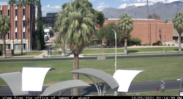
My first stop in Arizona was the Tucson area for two reasons: 1. Saguaro National Park, a place I'd never visited before and 2. The only webcam in the entire state of Arizona. Now, I know what you're probably thinking. "There's only one webcam in the entire state?" Well, there's only one webcam that's also a geocache in the entire state and it's located on the campus of the University of Arizona. So I ended up walking around campus that first day, looking for the webcam. Now usually, you'd just go to the coordinates and find the cache, but this one was a little bit trickier than that. You were told what building you needed to find, but the coordinates weren't at that particular building, but rather near a campus directory. Eventually I made my way over to where the webcam was and took a screenshot on my phone of me looking like I'm having a conversation with a fire hydrant on the university's campus.

On a side note, before smart phones, these were event tougher, because you literally had to phone a friend and have them get a screenshot on their computer. I did that here as a back up in case I wasn't able to get my own shot, but for this blog entry, I'm using my own photo. And this also gave me my 9th different icon, or type of geocache, in the state of Arizona, second only to California.

2 & 3. Saguaros

As noted above, the national park was one of my "must see" stops on my road trip to Arizona. I'm a national park enthusiast and this particular park has been on my bucket list forever. When we used to travel to Arizona to visit my uncle who lived in Scottsdale we never got as far as Tucson, but we could see saguaro cactus pretty much everywhere on the drive over to my uncle's house. They are fascinating and so the park which was a national monument at the time went on my bucket list. 

I never got to take the kids to see the park when they were growing up mainly because there's no car camping in the park, only backcountry camping. And so it sat there on my list until this past month when I decided that it was time.

I had plans to hike to a virtual geocache in the park, but the road leading up to that particular trailhead was closed while I was there, so I spent part of the morning walking a short nature trail in the park and the rest of the morning hiking on a trail in Tucson Mountain Park which is located to the east of the western portion of Saguaro National Park. The National Park is broken into two different sections, one located to the east of Tucson and one located to the west. The black and white photo, which I've entitled "The Clouds Laugh" was taken in Tucson Mountain Park while I was hiking and finding a couple of geocaches.

4 & 5. Chiricahua National Monument

My second stop on this trip was in Chiricahua National Monument in southeastern Arizona. The backstory for this park comes from a student I had probably 18 years ago. When I was teaching, my school room was always plastered with posters from various parks that I had visited or wanted to visit in the future. One day in class, this student came up to me and asked if I'd ever been to Chiricahua National Monument before. When I answered in the negative, he proceeded to tell me how beautiful the park was and what a neat place it was and he spent the better part of several class periods extolling the virtues of this park. When a 13 year old kid is that excited about something in nature, you pay attention and so this park went on my bucket list as well.

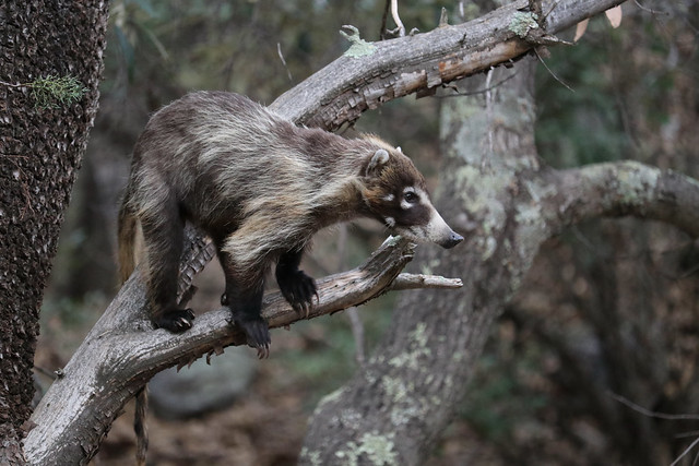
My plan was to camp here for two nights and enjoy a full day of hiking and sightseeing in the park, before heading back to Phoenix where I'd spent one more night before coming home. As I was setting up my tent at my campsite, I was interrupted by a couple of coatimundis wandering through the campground. I'd seen photos of them, but have never seen them in the wild, so this was really a thrill for me. 

These two were very skittish and took off as soon as I walked a little bit closer, so I didn't get a photos of them, but my luck definitely changed the next day as I had an entire troop of around 15 coatis wander through the river bed behind my campsite.

The troop, composed of females and youngsters wandered in the river bed and fortunately, I had my camera ready, just in case. They'd send the younger coatis up the juniper trees to pick berries and while feeding themselves up in the tree, they'd also drop berries down to the others waiting below.

Once they left, I packed up my gear and headed up to the top of the park where I'd take my hike in the Heart of the Rocks loop. My goal was to see some of the geological features of the park up close and to also get the Heart of the Rocks virtual cache there. The last photo posted here is the Pinnacle Balanced Rock and is pretty typical of the types of formations you can see in this park. 

Most of the formations are created by freeze and thaw cycles, so eventually, this particular formation will fail, but others will eventually also be created through this cycle as well. I did a second hike into an area called the grottos where the rock pillars are very close to the trail and several of the pillars have collapsed against each other. There is one point in the grotto where you can sit directly underneath a very large (garage sized) boulder being held in place by two neighboring pillars. Yeah, I sat there for a little bit.

And there you have my five photos of when I got out and played last month. Please stop by P.J.'s site and see how others got out and played last month. Please feel free to comment here. I will respond back and I don't bite. As always, thanks for dropping by.