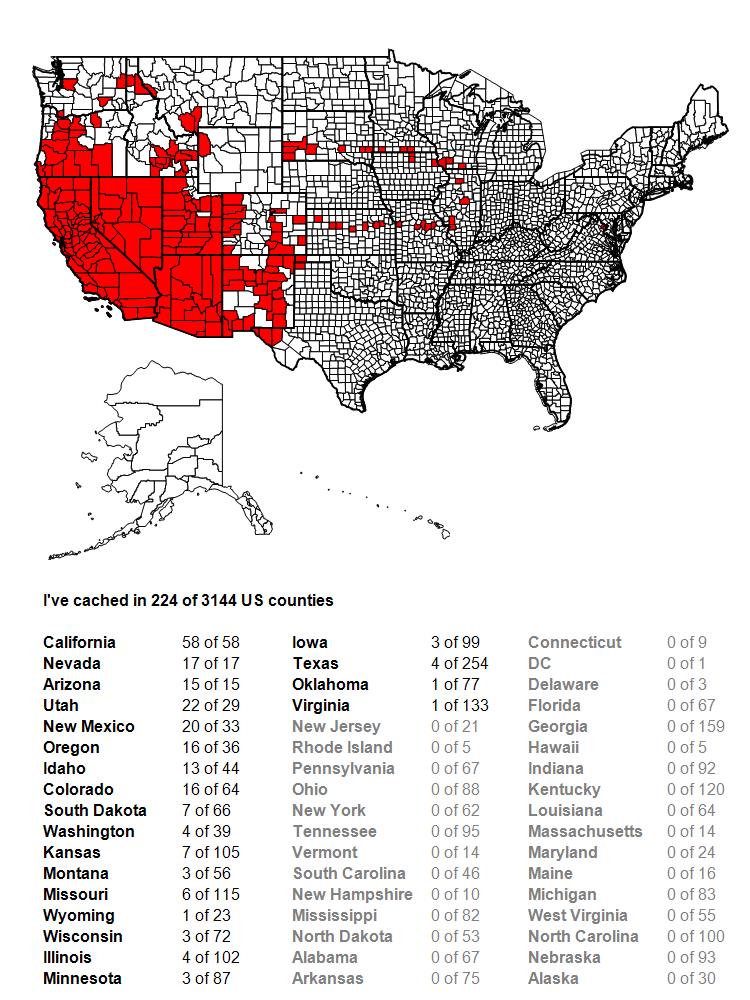
Showing posts with label Utah. Show all posts

Thursday, April 4, 2024

Webcams, Memorials and Challenges

This is a continuation of my road trip I took last September to Colorado and Utah. It will probably be the last one I write about this trip since I didn't take any photos on the last day of the trip. As noted in many of my other posts, this one will be entirely about geocaching, so if you're not interested, feel free to stop now. I won't be offended. I mean, how could I even know if you've stopped reading?

After touring around Dinosaur National Monument, I headed over to spend a couple of days in the Salt Lake City area of Utah. One of the goals for this area were the four webcam caches that are strategically placed along Interstate 15 in this area. 

For those of you unaware, a webcam is a cache where you have to place yourself at a certain point in order to get yourself on the webcam that is in that area. Either you call a friend, or use your phone to take a screen shot of yourself on the webcam to get credit for the webcam cache. Because geocaching.com doesn't allow the creation of new webcam caches anymore, webcam caches in general are becoming extremely rare with less than 200 worldwide. With four webcams in this general area, this is a goldmine for cachers seeking out webcam caches.

Because I was here on a Saturday, I started out my morning with a coffee event in the local area. It's always nice to meet the locals because you get some insight into some caches they've hidden or others have hidden. That being said, no one said anything to me about my attempt later in the day of going for those four webcams. As you can see, the first stop which was a couple of miles south of my coffee event was a success as I was able to grab a screen shot of me standing on the corner of State St. and Hwy 89. Unfortunately, that was the only one I was able to score that day.

The second webcam that I attempted was closer to the heart of Salt Lake City, which is where I ended up having a lot of problems. The closer I got to the center of town, the heavier the traffic became. What the heck was going on? As soon as I got to the corner where the webcam had been focused, I realized what was happening. There were massive amounts of people all converging on a spot about 3 blocks away from that corner. The University of Utah was playing U.C.L.A in a football game. No one at the coffee event bothered to tell me that it was football weekend there and so that one ended up being a no go as the nearest parking spot that I was able to see was over 2 miles away. I'll have to remember that the next time I end up in Salt Lake City and make sure I do that one on a non-football weekend.

The next webcam I attempted was virtually impossible to do because the webcam itself had been changed to observe another part of the highway and so getting a shot of me in it was next to impossible, so I concentrated the rest of my day on getting other kinds of caches including working on some Adventure Lab caches and finding some caches that helped me fill out some of the challenge caches I've already signed but haven't qualified for yet.

One of the Adventures that I worked on later in the day took me on a tour of this very nice park. Included in the park was a virtual cache that took me to an exact scale replica of the Vietnam War Memorial found in Washington D.C. I don't have any relatives who are found on the wall, so every time I see one of these, either of the traveling variety or something like this, I always seek out a particular soldier who was killed in the war and take either an etching of his name or take a photograph of his name. I am friends on-line with his sister and I know she appreciates the thought of someone else remembering him when they visit the wall.

The next day, I headed out of town, intending on spending the night in the southwest corner of Utah and geocaching along the way. The last photo was taken at a truck stop rest area in Tooele County, Utah. Why there of all places? Well, it was another county that I'd never cached in in the state of Utah and you already know if you'd been following along that my geocaching tends to revolve around challenges. I've found a cache in every county in California, Arizona, and Nevada, so now I'm working on Utah. I did a significant dent on this trip, but still have to get back there to finish off the state. Anyway, this last shot was a selfie I took at one of the filming locations for the movie Dumb and Dumber. Some of the things that you learn about areas when out geocaching are interesting and some things are just plain weird. I think this one falls into that latter category. Some of you might disagree, but that's what makes the world go round.

After finding this virtual cache, I headed back to Interstate 15 and southward. The next day would be spent driving home, traveling through four states in one day. There's a couple of challenge caches for that as well, but I've already signed and qualified for those challenges, so it was just a standard road trip caching day, which is why I didn't take any photos on that last day. 

Please feel free to comment. As always, I'll try to respond in kind and I promise I won't bite.


Sunday, March 3, 2024

Dinosaur Stew

This is a continuation of my trip to Colorado and Utah from last October. This particular day was mostly a travel day, getting myself from Grand Junction, Colorado, over to Salt Lake City, Utah where I would spend several days. When I worked out the itinerary of this trip, I realized that I was close enough to Dinosaur National Monument that it wouldn't make sense not to stop and at least whet my appetite on the fossils there, and so this particular spot also made the list of must sees. And as always, I usually bite off more than I can chew when I'm on trips like this, but it just gives me an excuse to come back at a later time.

I think if I were to do this monument up right, I'd spend several days here, probably camping. The monument has lots to offer including whitewater rafting, something that I'm not into, but I do know other people are and so I've mentioned it. For me, I was most interested in seeing the quarry of dinosaur fossils. I did not come away disappointed.

The park straddles the Utah/Colorado border and so is sort of broken up into two different unique areas. Since the quarry where the dinosaur bones can be seen close up is in the Utah side, I chose to head there. As I approached the monument border, I noticed a geocache outside the park boundary, so I decided to stop and find that one. It's very rare to find a physical geocache inside a national park area, because the National Park Service views it as litter. There are a couple of exceptions as there are several hidden in Petrified Forest National Park but they are maintained by a ranger in the park. Most geocaches you'll see in national park area would be either earth caches (geology based) or virtual caches which I've written about previously. In this case, the quarry area of the park had one of each that I was interested in finding.

I spent a good amount of time in the quarry area taking in all there was to see. The earth cache I working on asked me to examine the fossils along the wall of the quarry. It's estimated there are over 1500 fossils still embedded in the wall. I talked with a ranger and he told me that it's really more of a Dinosaur stew than anything else. The herbivores would be killed by the carnivores and the bones would be left after the carnivores had their fill. Eventually, the bones would be carried downstream where they were caught in this area by a large sand bar. Over time the bones were buried and eventually fossilized, hence the jumble of different kinds of dinosaurs all in the same area. 

The two bones you're looking at in the second photo are the femurs of a diplodocus and an apatosaurus (what we would call the brontosaurus back in the day). The photos don't really tell the tale, but both of those bones are about 6 feet in length and 18 inches in diameter.

The third photo gives more of a scale size to it. One of the tourist there was from Germany who was slightly taller than me, probably close to 6 feet tall. I asked him if he would stand near the fossil so I could get a size comparison, which he obviously obliged. This particular dinosaur, a camarasaurus, was the most common fossil found in the quarry area. This was one of the most complete camarasaurus ever found anywhere. The camarasaurus is part of the long necked dinosaurs commonly referred to as sauropods.

After taking in the quarry and finishing up the earthcache, I decided to drive further down the road to a virtual cache. I did a small hike out there to get what I needed to get and then headed back to the car and the exit so I could get to Salt Lake City in a timely fashion. I caught a little bit of rain on the drive there, but that was about all of the inclement weather that I got on this particular trip. All in all, I was very glad I stopped as this was one of those "new" places that I promised myself that I wasn't going to miss if I was in the area. It's not new anymore, but that doesn't mean I won't come back again sometime in the future.

Monday, February 26, 2024

When is Graffiti not Graffiti?

Every now and then I stumble across things that make me go "Hmmmmm." I'm sure most people have a working definition of graffiti, but I thought, why not write about it anyway. I'm sure most people would recognize the artwork on this truck which was parked on a street in San Francisco as graffiti.

According to most sources, "graffiti is a form of visual communication, usually illegal, involving the unauthorized marking of public space by an individual or group." In each of the three examples I'm posting with this, I'm pretty sure that the image makers were not given permission to create what they created, although some will argue, and I think rightfully so, that the middle example probably didn't need permission before creating what they did. But are we sure that the first example of the truck isn't a piece of art that's on display on the streets? I did not research who created the artwork on the truck. I didn't feel like I had to.

What I wanted to do was examine each piece and try and figure out if it's art, graffiti, or something else entirely. I think I would argue that all three pieces are art and graffiti. The phrase, "One person's trash is another person's treasure" comes to mind immediately. I think most people would say that the first piece is graffiti, but some graffiti is wonderful art at the same time. If you don't believe me, then look at the last photo I've attached to this. Those images, on the last four columns, are original graffiti that was placed on the Berlin Wall during the Cold War era.

The second one is the most interesting, I believe. If we look at the definition that I wrote earlier we can makes some judgements about it. Visual Communication?  I would say so. Illegal? Hard to say, but probably not. Unauthorized marking of a public space? Probably, but then again, the Ancients of Utah and Colorado probably didn't have the concept of ownership of land, so it was all public space and who's to say they didn't have permission to create those symbols on that rock outcropping? Today, I know that almost everyone who sees this would view it as artwork, not to be disturbed. I mean, the state of Colorado has viewing points set up alongside the road where you can look at these pieces of art from afar. There are also posted signs stating that the defacement of the art is considered a crime. 

So I guess, time plays an element in all of this. Even the National Park Service has weighed in on this issue. While they don't condone graffiti, they actually preserve graffiti in some of the areas they are set up to protect. I know of at least one instance in Great Basin National Park where writing inside of Lehman Caves inside the park have been preserved as part of the history of the park and cave. The writings (mostly signatures and dates) were done by employees of the National Forest Service over a hundred years ago. Time heals all wounds?

What it boils down to I guess is the public's perception of it or maybe the authority's perception of it. The Berlin Wall, when it was all in Berlin was a striking example of this. The western side contained all of the graffiti. The eastern side was pretty much pristine. Different forms of authority obviously made this a reality. People in West Berlin let their feelings known about the wall in the one way they could at the time and that was by drawing on it. People on the east side didn't not have that kind of freedom since there were barriers in place that prevented people from even getting close enough to it to place graffiti on it.

And while I don't like the gang related graffiti that is so pervasive in some areas, I'm not going to deny that some of it is amazing artwork. What's your take on this? Graffiti? Art? A combination of both? As always, comments are welcome.

Wednesday, October 18, 2023

Road Trip!

This post is primarily dealing with geocaching, so if you're not interested, then you can probably stop reading right here. Things have settled down tremendously over the early part of the year where everything seemed to be upside down. In my last post which I published back in the early first week of August, I mentioned that one of my happy places was in planning road trips. This post is the first of several detailing the road trip I took to Colorado and Utah in the month of September.

The first two days of the trip were mostly traveling, getting to my first destination in Colorado, so it was primarily driving and taking breaks here and there for geocaching. Most of the geocaches that I wanted to find on this trip were either going to be virtual or challenge caches as those two were my primary focus. I would also be working on several challenge caches, including one that wanted me to find at least 6 different types of geocaches in 20 different counties. Since I had already done that in 19 different counties, I only needed one more, so I had a focus on Iron, Salt Lake, and Washington Counties in Utah, as well as Grand County in Colorado. My first night's stop was going to be in Cedar City, UT, located in Iron County, so that's where I figured I'd be able to complete that challenge.

I didn't end up getting what I needed in Iron County, since I couldn't find a particular cache near my motel, so I settled on other things that first night. One of the last caches that I ended up finding on the first day was a virtual cache in Cedar City that focused on the history of a fort that had been built there. In the morning I tried for a couple of other cache types nearby, but it just wasn't meant to be for Iron County and so I took off for Grand Junction, CO which would be my next stop.

Once again it was a full day's drive to get to Grand Junction, so there wasn't a lot of sight seeing involved, but mostly driving and stops to find geocaches. One of the stops that day involved a virtual cache which highlighted the first Olympic gold medal athlete of Utah, Alma Richards. I'm pretty sure that something like this probably wouldn't get approved in California, but I was surprised with this one since it took me literally onto the high school campus that Richards attended, onto the track, during the school day, while a physical education class was finishing up their running activity near the monument seen in the photo. No one said anything to me, no one questioned me as I walked on to campus. It was a little on the weird side to say the least since I'm used to schools being a little bit more security conscious when it comes to strangers walking onto any school campus. Anyway, I got the information I needed for the virtual and then quickly got off of campus and back on the road.

Another goal for the trip was to find at least one cache in each county I traveled through on the trip. This was a success as I only failed to find a cache in one county that I traveled through and ended up finding caches in 14 new counties. Yes, you guess it. I'd signed a challenge cache that wanted me to find caches in at least 200 counties. At the beginning of the trip, I was at 199, so Paiute County just off I-70 became my 200th county cached in and the first new one on the trip.

At a rest stop along I-70 was a great viewpoint called Spotted Wolf Canyon. There was a virtual cache here which I completed and then it was just a matter of stretching the legs a little bit. This particular canyon was amazing as it highlighted not only the view, but the engineering that went on to wind I-70 down through the canyon at a rather steep price back in the day. This spot also highlighted one of the main reasons why I've really come to enjoy geocaching so much. I've said it many times in the past, but it bears repeating. I probably would have missed this spot entirely were it not for geocaching. This silly little game has taken me to several spots that I never would have visited were it not for the game and that included spots in places like Yosemite Valley, that I felt I had explored extensively and there was no possible way that there would be something new to see in Yosemite. Geocaching proved me wrong there and it has continued to take me to awe inspiring and interesting places.

Finally, sometime further down the road that day, I ended up finding a traditional geocache. I actually found several traditionals during the day, but this one was intriguing in that when I signed it, about five signatures above it was another cacher's stamp who lives in the same area that I do. This is not the first time I've encountered things like this, but just the latest. The last time was when I encountered another local geocacher's name in a cache that I found in New Mexico. For the most part, geocachers love to travel, so this shouldn't be that surprising, but it's always cool to see friends' names in the log sheet that you've just signed.

That evening, I stopped in Grand Junction, CO which would be my base camp for the next three days or so. I did some caching in the area, actually bumped into a couple of local Grand Junction cachers who were looking for the same cache I was. When I'm on a road trip like this, I usually try to host an event somewhere just so I can meet the local geocachers. Grand Junction was no exception, so I asked them whether they were planning on attending my coffee event the next morning. They said they'd be there and then we ended up finding that cache, plus another cache nearby that had eluded them before. After finding that second cache, we said our goodbyes with the promise of seeing each other the next morning and I headed back to my motel to log my caches for the day and to get a good night's sleep. The next day promised to be a good sightseeing day for me as I was going to tour a nearby national monument, but I'll write about that in a future blog entry.

Thursday, August 31, 2023

Happy Place

It's the end of the month which means it's time for P.J.'s monthly photo blog challenge. I thought about this one, then figured that I have a bunch of happy places, things or actual places that I enjoy immensely, so I thought I could make this more about all of my happy places as opposed to just one happy place. I mean, why limit yourself? And I'm sure if I really tried, I could come up with some more, but these are the ones I've chosen for this month's photos and they are in no particular order of importance.

1. It's all about planning

Right now, I'm in the middle of my second round of immunotherapy for my cancer treatment. This is a maintenance round, primarily meant for preventive care, so that's a very good thing. I had my first treatment on Monday and I have two subsequent treatments on the 5th and 12th of next month and then it appears I'll get another 3 month break. What this means in the long run is I'm planning a road trip to Utah and Colorado.

One of the things that has been really frustrating about my illness is it's not really allowed me to plan any kind of trips because I've had appointments, surgeries, and procedures that have take top priority. I get that, but with more free time, I've been able to start planning for future trips again.

I love planning road trips. I love to look at maps and guidebooks and determine what route I will take in order to fully maximize the time I have for this specific trip. This time, the plan is to head to Grand Junction, Colorado and tour Colorado National Monument and Black Canyon of the Gunnison National Park

I've been to Black Canyon of the Gunnison way back when I was around 13. This was actually so far in the past, the park was a national monument at the time and has since been upgraded to national park status by an act of Congress. I've never been to Colorado National Monument, but I intend to spend a day at each park and make Grand Junction my base for the three days and two nights I'm in the region. 

And I will be the first to admit that I started planning this road trip too early. I've pretty much set up my itinerary, have my hotels books and know what I want to do each day and I WANT TO GO NOW! But I can't, because of my upcoming treatments. I should have waited until next week perhaps to start planning, but you'll see later in this post that waiting might not have been a really wise choice either, because next week is going to get busy.

2. Papa and Gaga time

We didn't do this very often last year, but once I got sick, time became a little bit more precious and my daughter and son-in-law started having regular video chats with us so we could see the little one. Usually these happen around dinner time, so in essence we get to eat dinner with our granddaughter on an almost daily basis and we live 300+ miles away from each other. This is just one of the many screenshots I grabbed a couple of weeks ago when we were having dinner together.

Just watching and listening to her babble about her day, what's she's eating, her insistence on seeing our two Pooh bears that she knows are at our house, and seeing her new developments that seemingly happen on a daily basis really takes me to a happy place.

I've heard it said that being a grandparent is the best and I've probably said this more than once on this platform, but it really is. And she's coming to visit in about a week. It will be a short visit, but we are both really looking forward to seeing her and her parents.

3. The Wonders of Nature

I will never be not astounded by the wonders of nature around us. It's probably why I love to travel, to experience new things in nature to me. It also allows me to practice my art of photography and although that's developed and evolved over the years, especially with my reliance more and more with my phone as opposed to my DSLR, I still love going out and hunting down that elusive butterfly, or taking a wonderful landscape photo from some place I've visited. This particular butterfly allowed me to get my phone about two inches away from it, almost as if it knew I wasn't going to try and capture it.

My parents instilled in me a love of nature and I fully want to enjoy it for as long as I possibly can. Already in my mind, I'm planning other trips that I can take in the future. 

4. Hiking

I realize this photo isn't the greatest photo, but it really encapsulates what I enjoy about getting out in nature. I've been asked why I never took up mountain biking as it appears as if I'd be a good candidate for that particular type of exercise and recreation and I think it's mainly because I feel that biking would intrude in some of the other happy places I also like to enjoy, like photography, nature and geocaching. I mean, if you're flying by something at 20 miles per hour, by the time you stop to "smell the roses" or pursue the butterfly, the butterfly has already flown away. And so I walk, and I walk, and I walk.

Before I was retired, I was pretty much limited to hiking on the weekends. Now, I just get up, look outside and if the day looks promising, I'll put on my hiking shoes and head out to a favorite trail and enjoy the day. And what's really funny about all this is, as a school teacher, we're used to loving our summers. Now, I would honestly say that summer is my least favorite season of all. It's so dang hot that unless you get up at the crack of dawn and get out on the trail, it's usually pretty miserable out there. It's so much nicer during the cooler months of fall, winter and spring, when you can go out just about any time of the day and get a good hike in without feeling like you've been on a summer death march. Plus, now that I'm retired, I can hike any day of the week, so I don't have to exclusively go on the weekends when the trails are crowded. Nice quiet trails where I can really enjoy nature take me to a happy place.

5. Geocaching

Did you really think I could get through an entire blog post talking about happy places and not talk, at least a little bit, about geocaching? I didn't think so.

So much of the past 22 years of my life has been intertwined by this silly game that I discovered. As one of my friends, who I later introduced to this game said, "Geocaching. It's hiking with a purpose!" Although I'm not sure I agree with this sentiment entirely, I did see where he was coming from with his explanation.

And yes, part of my next roadtrip will be geocaching related. I'm actually planning on hosting two event caches while out on the trip, one in Grand Junction, Colorado and another one in Salt Lake City, Utah. What better way to meet up with other geocachers in the area than by attending an event. I looked at my itinerary and then searched to see if there were already events planned (there weren't), so I decided to host my own morning coffee events. I usually do this when I'm on a road trip, but this is the first time I've hosted two events while out on a trip. It's kind of ambitious for a 7 day trip, but I'm up to the task.

It's always enjoyable to talk with other geocachers about the game. Who knows, I might end up going caching with one of the people who show up at one of my events.

The other goal of this trip is to get the webcam caches that are in the Salt Lake City area. A webcam cache is where there's a public webcam that you need to stand in front of the webcam and either have a friend back home get a screen shot of you, or you can alternately get a screen shot of yourself off of your phone.

I've signed several challenge caches for finding webcams and since there are four different webcams in this area, it's like a goldmine for cachers working on webcam challenges. To put things in perspective, there are approximately 203 active webcam caches, so they are exceedingly rare. Webcams are no longer recognized as "real" geocaches, so these are the ones that have been grandfathered into the system. They are not getting replaced, so when one gets archived, it's gone and there's not going to be one to replace it. That's why when geocachers see there's a webcam close by, they want to get their photo taken, because you never know if that particular webcam might disappear sometime in the future. Of the 10 that I've taken a photo at, only 4 of them are still active.

And there you have it, my take on the theme Happy Place. Please stop by P.J.'s page and see how other people interpreted the same theme.  And as always, please leave a comment. I won't bite.


Monday, September 16, 2019

Potters Pond

This is a geocaching blog, so if you're not into geocaching, you can probably skip this one right now.  But if you enjoy my geocaching rambles, then you'll probably want to continue reading.

Following my night of camping at Cedar Breaks National Monument, I headed to Potters Pond in central Utah.  Most of you who are into geocaching know that there are challenge caches out there for all sorts of things.  Some are silly and others are rather challenging, for want of a better word.

Challenge caches are just that; they challenge you to do something in order to claim the find on the challenge cache.  They can be as simple as find 25 geocaches, to finding a geocache that was hidden in every month since geocaching has been around, to all sorts of other options in between. I worked toward three different challenges on the second day as I drove to Potters Pond.  One was for 100 contiguous county finds.  Before this day, I'd found geocaches in 95 contiguous counties, so obviously, I needed 5 more counties connected to the ones I'd already found geocaches in to get me to 100.  By the end of the day, I'd be up to slightly over 100, so mission accomplished and by the end of the trip, I'd be up to 117 contiguous counties.

The second challenge I was working on was to find more caches above 8000 feet. This particular challenge, I haven't found yet, but it's on my "to do" list.  It's located up in the Sierra Nevada, above 8000 feet obviously, but it would also mean a hike along the Pacific Crest Trail, something that I want to do more of anyway.  It's on the back burner, but as long as I'm at altitude, I might as well get as many as possible.  I'm not sure how many I have at the moment, because it's more difficult to check (I'm on a Mac, so I don't have ready access to GSAK, a Windows based program for geocaching), but I found 12, possibly 13 more that were at over 8000 feet, so I added to the list.


The third challenge was getting Potters Pond. For the uninitiated in geocaching, the Jasmer Challenge challenges you to find a geocache that was placed in every month since geocaching started, way back in May 2000.  Yes, this means you have to find a cache that was hidden in May 2000, plus June 2000, etc., all the way to the current month.  Before this trip, I needed 3 more months, June, July and August 2000.  On my road trip two summers ago, I'd found the oldest geocache in the world, Mingo, so May 2000 was covered.  I'm also fortunate, since I started geocaching in March 2001, there were some of those older caches still around.  In fact, my very first cache find was hidden in December 2000, so I've never had to worry about that particular month.

August 2000 has always been kind of problematic, since there are only 3 geocaches in the entire United States that are still around that were hidden in that month, one in upper Michigan, one outside of Atlanta, Georgia and Potters Pond.  Potters Pond is also at altitude and under snow for probably half the year or so, so it's definitely a summertime grab.  So that became the focus of the day.

Potters Pond is located along a trail near a campground.  The tricky part is finding the correct trail.  Once you find the trail, it's a pretty easy maneuver to get back and find the cache.  I did my homework and when I arrived at the campground, I hiked back, found the correct trail, found a couple of other caches along the way, then walked back into the woods and eventually claimed the prize.  The one photo of the actual pond is what I have as proof that I was there, mainly because the mosquitos that day were horrendous.  As long as you kept moving, you were okay, but as soon as you stopped, they descended, as if they were vultures coming across road kill, even biting through my shirt.  Needless to say, I traded travel bugs quickly, signed the log quickly, replaced the cache quickly and got moving again.  But, I now have August 2000 off of my list and I'm only a road trip to northern Oregon away from completing the Jasmer, as there are caches still around up there from June and July 2000.

If you want hints on how to get there, which roads to take, don't hesitate to ask someone who's already found it.  Bushwhacking would take a lot out of you.  The trail leads right to it.  I listened and learned.

Thursday, September 5, 2019

Cedar Breaks

When I started my first road trip of 2019, I knew my first stop would be Cedar Breaks National Monument, located just east of Cedar City, Utah.  There were a couple of reasons for camping here, one that it's usually very uncrowded and so you pretty much have the pick of campgrounds.  A second reasons was there was an earth cache in the park that I wanted to find so I could complete a geocaching challenge of finding an earth cache in four different states on the same day.  As it was, I'd already found an earth cache south of where I was, but camping there still made sense as it was a good jumping off point for my next day's adventures.

I've camped in Cedar Breaks previously and it really is a good jumping off point for various spots around Utah that we have wanted to explore.  For those of you who aren't familiar with Cedar Breaks, I think I can best describe it as a miniature version of Bryce Canyon National Park.  It doesn't attract the visitors that Bryce Canyon does, mainly because there's not nearly as much to do there.  The features in the park are nice, but you can't hike down into them the way you can at Bryce Canyon and that's by far and away the best feature, to be able to hike among them.  And so it becomes more of a jumping off place.  You walk the rim, you look down on the hoodoos below you and then you move on.

But, apparently, the word is out that this is a nice place to visit.  When I got there around 5:30 in the evening, the campground was pretty much filled, so I didn't have a great deal of choice in spot, but I was still able to snag a nice spot for the night.  Once I had camp set up and dinner in my belly, I decided to head out on a hike because I still had plenty of daylight.


Because I've been there previously, I decided to take a trail I hadn't explored before which was the Alpine Pond Trail which led off of the Chessman Ridge Overlook and walked along the eastern edge of the amphitheater of Cedar Breaks, leading to an alpine lake at 10,400 feet of elevation.

It was a pretty much level hike because most of the park where visitors are is all above 10,000 feet, but the air was thin. I probably overdid it a little bit on this hike for a couple of reasons.  One, I was running out of daylight and I wanted to get some good shots while there was still light and two, which is in hindsight, I was a little bit dehydrated after driving all day.  I definitely had not kept up a sufficient amount of fluids in my system that day and I was going to pay for it later with a little bit of altitude sickness.

Another reason I decided to take the trail was also to escape some very loud college students who decided to park themselves out on Chessman Overlook and scream at each other from 3 feet away or so.  Seriously?  You're 3 feet away from each other and you feel the need to scream?  I can already hear my daughter in my head saying, "GET OFF MY LAWN."  It didn't really matter, because I escaped the noise by hiking away from it, and when I came back, they were gone and I had the overlook to myself.

The hike was very peaceful and I had lots of opportunities to see the amphitheater through the trees.  There were lots of wildflowers alongside the trail: Scarlet paintbrush, Colorado Columbine and Shootingstar being the most abundant that I saw.  The trail followed a creek that flowed down into the breaks and eventually led to the pond. I followed that creek to the alpine pond where I was rewarded with some very nice reflections of the sun glowing off of the trees along the opposite bank.  I lingered there taking several different photos with different exposures hoping that one of them would turn out decently, then decided to take the same trail back to the overlook which was a very good decision.


Had I taken the trail in a loop instead of an up and back, I would have missed the sunset on the rim. After enjoying the sunset and taking a multitude of shots, I drove back to my campground and settled down for the night, hoping to have a restful night sleep.  Unfortunately, the high altitude did me in that night and I didn't sleep very well due to headache and upset stomach.  Fortunately, fluids and food the next morning, plus a drop in elevation leaving the monument helped me recover rapidly. In the past, I've always slept well at Cedar Breaks and the only thing I can attribute all of this too was my intake of fluids during the drive up there from Southern California.  I didn't have any problem the rest of the trip, even though I was at altitude for most of the trip.  I made sure I was properly hydrated and was probably acclimated to the altitude as well.

In the morning, I walked along the rim, taking photographs, checking out the visitors center when it opened and just enjoying the sights the park had to offer before I hit the road again.  I could hear Utah's oldest geocache calling my name.

To be continued.....

Sunday, September 1, 2019

The Written Word

August has been a very enjoyable month.  For the first time in 20 years or so, I didn't go back to work in August.  Yeah, school used to start in September, but it's been opening up in August for quite a number of years.  In fact, today is my youngest's 24th birthday.  His due date was September 12th.  I was concerned at the time, because that was the first day of school for me.  Now, school begins the first week in August.  But as many of my friends know, it's not my circus, not my monkeys anymore because I retired at the end of the last school year in May.

P.J. has his monthly blog challenge and this month's challenge, for the month of August was The Written Word.  At first, I thought I wouldn't be able to put anything together, photographically for this particular month, but when I look back over my photos I took this month, I realized that I have quite a selection from which to choose.  And so it goes.

August, as noted above, was very different this year.  I actually spent time in five different states, so I've decided that each photo this month, not only should convey the theme of the written word, but should also represent each one of the different states that I spent time in this month.  I've posted on Facebook photos of signs leading into National Park sites that I visited and said, "I'm a National Park Geek."  And someone joshingly pointed out that maybe I was a sign geek.  Well, that's possible.  I love how signs sometimes give you so much information with very little words.

1.  Hiking
I like to hike, always have, always will.  I spent the month hiking a lot.  In fact, I spent a large portion of the summer hiking. One of my favorite hikes is a 5 mile loop in the Claremont Wilderness Park, a park that I didn't know even existed back in 2001.  That was the park that started me on geocaching, mainly because when I discovered geocaching, this park was where the closest geocache was hidden from my house at the time.  It was literally 7 miles away and a half mile hike.  I bought a GPS, took the boys out that Saturday and we found the cache.  We didn't walk the entire loop that time and there have been many times in the past I have not hiked the loop, mainly because I was out of shape at the time.  I'm not sure I'm in great shape now, but I do know that I'm in much better shape than I was back in 2001.  This is a good thing because I want to enjoy my retirement for as long as possible and being in good shape will help me achieve this goal.  So the written word on the sign post either tells me how far I've gone, or how far I still need to go to complete the loop.  In this case, I took it after I'd already hiked 4 and a half miles.  This was taken in California.


2.  Road trip
In the middle of the month, I took a week-long road trip through four states, just so I could feel that my routine was a little bit different for this month as opposed to most Augusts over the past years.  I grabbed Interstate 15 and took it north, traveling through Nevada and then into Arizona where the second photo was taken.  I love the color in this photo and amount of information.  
At least 7 different signs tell you a bunch of information that you need to know as you barrel your way into Arizona at 75 mph.  And no, I didn't take this photo while flying down the Interstate.  I actually did pull over and take the shot, although now that I look at it, I wonder if that would be considered emergency parking?

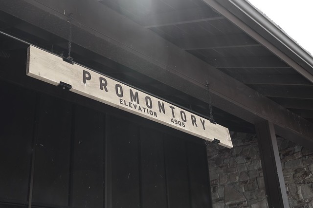
3.  The Golden Spike
That first day, I eventually ended up in Utah.  A couple of days later, I decided that my next point of destination would be Golden Spike National Historic Site, the site where the trans-continental railroad joined the country together in May, 1869.  The country would never be the same.  Promontory, Utah was a boom town, which grew up at the site of the Golden Spike, but soon died when the railroads moved operations to a more profitable route.  I spent time time at the site watching the engines move up and down the tracks and I also got a nice hike in along the old railroad rights of way.  I say ways, because the two railroad companies literally created grades for the two lines that went by each other for 230 miles or so, mainly because they hadn't agreed upon a meeting place and they were getting paid by the mile by the United States Government.  When they finally agreed upon a meeting place that at Promontory, the grading stopped and they worked toward that point.  I also learned that the original golden spike is nowhere near Utah anymore.  
Because the Union Pacific Railroad abandoned these lines first, the Central Pacific ended up taking over this part of the rail lines and so ended up in possession of the golden spike, which is now located at Stanford University.  I guess I need to go to Stanford to complete this trip.

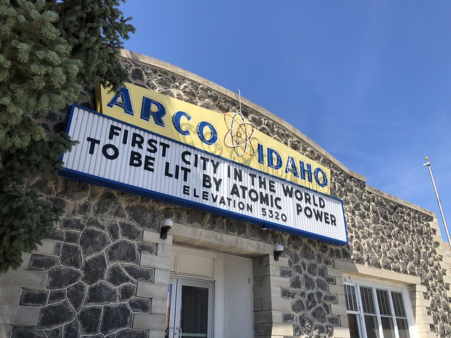
4. Atomic Power
After Golden Spike, I ended up in Idaho for my next adventure.  I was going to be camping at Craters of the Moon National Monument. Taking back roads to the northeast of the monument, I ended up driving through the small town of Arco, Idaho. Now, when you think of Idaho, do you think of atomic power?  Probably not and although I was peripherally aware of Idaho's contribution to atomic power, I was not aware that Arco was the first city lit by electricity via atomic power, something that the town, obviously, is very proud of. This is one of the reasons I love road trips like this.  You stumble upon all sorts of interesting tidbits of information that you might have missed if you just flew into an area with one destination in mind. 

5. Extra Terrestrials
After camping at Craters of the Moon and also Great Basin National Park, I decided to come home. But, as a geocacher, I had to stop here.  This last shot I found at a gift shop at the beginning of the E.T. Highway which runs along SR-375 in Nevada just east of Hwy 93. It's become somewhat of a Mecca for geocachers around the world, because it's one of the major "Power Trails" in existence.  A power trail is a route set up by geocachers where there are a lot of geocaches along a specific route. Geocaches are not supposed to be closer than 528 feet apart, so a power trail typically has one every 10th of a mile for a long distance, in this case, the E.T. Highway has a geocache hidden every tenth of a mile for 200 miles.  Yeah, the math works out to 2000 geocaches.  I found the first one in the series and then turned around and continued on my way home.  At least now I can say I've geocached on the E.T. Highway.  Whether I ever get back to it or not is an entirely different story.  I have, however, signed a challenge cache near the beginning of the E.T. Highway, which challenges me to find 1000 geocaches in the state of Nevada.  With only 76 finds in the state, I have a ways to go and this power trail would help me complete that challenge.

So that completes my interpretation of P.J.'s month blog challenge, the Written Word.  Please click on the link and check out other bloggers' interpretations of the theme for this month.