Showing posts with label Texas. Show all posts

Saturday, May 22, 2021

Five States in One Day

I was thinking I hadn't written here in awhile, but I was surprised to see it's been almost a month since my snake post. This continues my series of posts regarding my 2017 summer road trip.

When last on this series, I'd written about Mingo, the oldest active geocache in the world, located in eastern Kansas. The next day, we left heading to northeast New Mexico, but our route took us on a non-intuitive trek through five states, Kansas, Colorado, Oklahoma, Texas, and New Mexico. Had I been thinking a little bit more, I could have routed us through Nebraska and/or Wyoming and Utah. The purpose, obviously was to find at least one geocache in each state. And yes, there's challenges out there for finding caches in several states in a single day. 

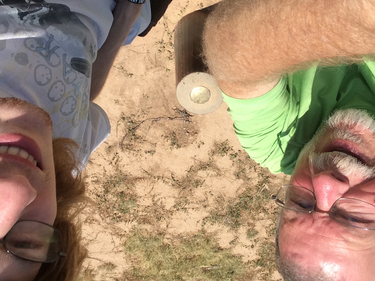
I've signed one that challenges you to find caches in 7 states in a day. It's a lot easier on the east coast than on the west coast, but this one day took us through 5, so even in the west it's possible. Start at the edge of one state, travel through 5 others and end on the edge of the next state, which is about what we did at least to get 5 different states. The photo is of the two of us getting a virtual cache at the confluence of the borders of Texas, New Mexico, and Oklahoma. Believe it or not, this was the second confluence of three states that we'd visited on this trip, having previously visited the confluence of South Dakota, Iowa, and Minnesota. Once the pandemic restrictions have totally lifted, I guess I'll need to eventually get back to the four corners area and get a photo of me there as well.

Things I learned on this day's travel. 

1. Eastern Colorado is much more part of the Great Plains than it is of the Rocky Mountains. 

2. Smart phones and time zones are remarkably accurate. There was one cache we found, where we were driving on the road into New Mexico. I parked the car at the side of the road, walked across the road to find a cache at the northwest corner of Texas. In the time I walked across the road, my smart phone had adjusted itself to Central Daylight Time (Texas) and once we walked back on the other side of the road, it had adjusted itself back to Mountain Daylight Time (New Mexico).

Thursday, November 14, 2019

Above ground next

After touring Carlsbad Caverns, I had some extra time and I really didn't want to just hole up in my motel room, so I headed south out of New Mexico into Texas towards Guadalupe Mountains National Park. Guadalupe Mountains is an extension of Carlsbad Caverns, except, this is above ground. In other words, the limestone marine fossil reef that's below ground in New Mexico, is above ground in Texas, forming the tallest mountains in the entire state of Texas.

The park is primarily a wilderness area, so there are very few roads in the park, either paved or dirt roads. Consequently, you really need to be prepared when you visit this park. The original plan was to camp here, then head up to Carlsbad Caverns and explore what I could here. As luck would have it, this would have been the only place where I would have camped on this road trip, so I opted to leave the camping gear at home and just motel it on this trip. Although the campsites are first come first served, this park has a lot of visitors in the off season because the climate is fairly mild and it would have been problematic to even find a good campsite. So it ended up being a day trip.


I explored the visitors center, took in the National Park movie they offer, then decided to explore what I could in the time I had left in the day. I actually drove out of the park further south and to the west to get some great views of El Capitan, which is the main piece of rock at the end of the exposed mountain range. I'm not sure if you can actually see Guadalupe Peak, which is the highest point in Texas, from the road. I believe the tall peak to the right of El Capitan in the sign photo is obscuring Guadalupe Peak. There is a trail leading to the top of the peak, but that's a good 8 hour round trip, so I opted for a hike in McKittrick Canyon, which is very near the northern border of Texas and southern border of New Mexico.

I ended up hiking the nature trail at McKittrick Canyon, which was a short loop trail, which was very enjoyable and allowed me to get a feel for the entire park, but if I'd had more time, I would have worked my way back up into the canyon as there was a lot to explore there. As noted above, had I camped there for a couple of extra days, I think I would have also hiked to the top of Guadalupe Peak. Eventually, I can see myself coming back here, possibly in the next five years. I'll be in somewhere in Texas in 2024 for the next solar eclipse of the sun and this might be a good starting point. Hike a day or two, then work my way down to Big Bend National Park, then further east to view the eclipse. More road trips down the road.

Thursday, October 31, 2019

Liquid

Once again, it's the end of the month, which means it's time, once again for P.J.'s monthly blogging challenge. The theme for this month was liquid. I have to be honest with this one. When I first saw the theme at the beginning of the month, I figured there would be no way that I would be able to come up with anything for the theme, let alone five shots. But, once the month got underway, I saw ways that this would work, so bear with me as I think I'm stretching the boundaries a little bit with this theme, but at least I didn't have to resort to any photos of snow. Snow? Yeah, I actually saw it snow in a city for only the second time in my entire life, but that's another story that I'll tell at another time.

I'm actually doing these in chronological order, which means this first shot was taken on October 20th. Yes, I did the entire theme in less than 10 days. At first, I thought that I might get by with 5 different cave photos, because after all, what creates a cave but water? And so I figured I was done, but I'll not post a bunch of photos of the caverns, because after all was said and done, I was able to come up with 5 different liquid shots. And to also be honest here, this blog entry is sort of a teaser for other entries I'll be writing about next month.

1. Phoenix, Arizona
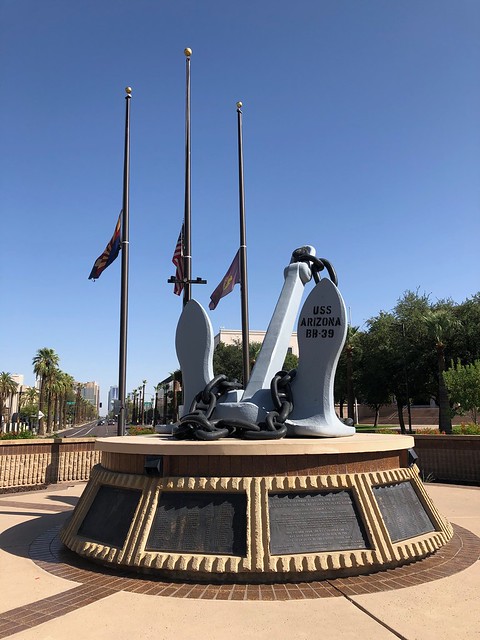
In my last post, I mentioned that I would be on an extended road trip and I just came back from that one Sunday. The main purpose of the trip was a visit to the Denver Art Museum to see a very large collection of Claude Monet paintings. The collection was only going to be there from October to February, so I figured this would be the best time to go to avoid really bad weather. Anyway, the first day of the trip took me through Phoenix. And, as usual, I spent some of the time on the drive geocaching. I ended up in downtown Phoenix, where there is a large war memorial to all of the different wars our country has been involved in. Part of this park is where I discovered the USS Arizona's anchor. Pulled from the liquid depths of Pearl Harbor in Hawaii, this anchor is on permanent display at this park in Phoenix. Around the base of the anchor are all of the names of the brave men who perished on that fateful day in 1941.

2.  Guadalupe Mountains National Park
This was a new place I'd never visited before and originally, I had planned on camping here, but things fell through on the opposite end of the trip, so I ended up staying at motels along the way. This was actually a good thing because camping was very limited in this park. The Guadalupes are the extension of Carlsbad Caverns, only above ground. I spent most of the morning exploring the Caverns, and after having thoroughly explored them, I ventured south to this national park, just across the border in Texas. This park is mostly wilderness, which means little to no roads and mostly backcountry camping and hiking, something I wasn't equipped for on this trip, but I was able to get a feel for this area nonetheless. 

West Texas is pretty much desert and the Guadalupe Mountains rise like an island out of this desert, providing refuge for an abundance of wildlife and plant life. I took this photo of this prickly pear cactus mainly because I liked the contrast of the brown and greens with the light violet of the flowers on the left. And if you're ever stuck out in the desert without water, you can, in a pinch, open up the cactus and get some liquid refreshment which will sustain you for a little bit.

3. Monet
The reason this trip happened in the first place was because of this collection of paintings. I can't remember where I first heard about this exhibition, but as soon as I knew about it, I started making plans to see it. The exhibition was falling at a perfect time: the fall and winter following my retirement. Since this exhibition was only happening during this time period, I probably wouldn't have been able to see it since I was working during most of that time. That's one of the benefits of retirement. I highly recommend it.

The main building of the Denver Art Museum is undergoing extensive renovation and the museum is in the annex building across the street. This means the collection of artwork on display is small at this time, but they had some interesting works dealing with the study of light. 

The bottom two floors of the annex were dedicated to Claude Monet and his life. Each of the patrons were given audio guides to learn more about the paintings and about different periods of his life. The galleries were arranged in approximately a chronological order. Since he created most of his lily pad and pond paintings near the end of his life, this was the last room of the gallery that I walked through. The way the liquid paint created the illusion of the liquid water in the lily pond is just amazing, in my opinion.

4. Chocolate Porter
Coming home later in the week, I ended up in Albuquerque, New Mexico. One of the nice things about traveling is checking out the local cuisine. There were times on this trip where I'd eat at a place that I was familiar with because I just wanted a quick meal and there were times when I wanted something a little bit more tasty and different. That night in Albuquerque was one such nice, so I decided to try a local barbecue place. It was recommended to me by the waitress that I try the burnt ends sandwich, a decision which I will not regret. I also have an affinity for dark, very dark beers, the kind you can almost chew. This chocolate porter certainly filled that bill and went quite well with the barbecue sandwich I had. The Nexus Silver Taproom will be someplace I will probably visit again should my travels take me through northern New Mexico.

5. Continental Divide
Finally, on my next to last day of my trip, I traveled from Albuquerque to Flagstaff, Arizona where I would spend my last night. Heading toward Denver, I missed when I exactly crossed over the continental divide, but this spot along Interstate 40 is very hard to miss. With signs on either side of the freeway, it's pretty much a spot where travelers stop and get their photos taken.

It's also the spot, where liquid falling to earth gets separated. Rain and snow falling on the eastern side of the continental divide will eventually make it to the Gulf of Mexico. In this case, the water would flow into the Rio Grande, which forms the southern border of Texas with Mexico. Rain falling on the western side would eventually flow into the Gulf of California and into the Pacific Ocean. Most of the rain that fell here would flow eventually into the Colorado River and through the Grand Canyon.


It's always intrigued me how cartographers were able to graphically map this out and figure out where each little stream would eventually drain. If you've ever looked at a map of the continental divide, you'll see some very interesting details. In southern Wyoming, it actually splits in two, creating a basin where the water doesn't flow to either, but either evaporates or flows downhill to the lowest point in that basin where it percolates back down into the groundwater. Further north, in Yellowstone National Park, there's a lake that literally sits right on top of the continental divide. The lake has two outlets, one flowing to the Atlantic Ocean and the other flowing to the Pacific Ocean.

For hiking enthusiasts, there's also the Continental Divide Trail, a national trail which loosely follows the Continental Divide from the southern border of New Mexico all the way to the northern border of Montana. Somewhere in this area, I also crossed over that trail.

And there's my interpretation of the theme liquid. Some might call this a stretch, but it worked for me. Please check out P.J.'s blog and scroll down to the bottom. You'll see other blogs and their interpretations of the same theme. And as always, feel free to comment. I won't bite.