Showing posts with label New Mexico. Show all posts

Tuesday, August 10, 2021

Petrified Forest National Monument

Once again, it's time to look back on my youngest and my 2017 road trip to Wisconsin and back. When last we checked, we had stopped at Capulin Volcano National Monument in northeast New Mexico. The following morning, we headed off with the intention of making it into Arizona, somewhere near Petrified Forest National Park. As we drove we, of course, geocached along the way, because that's what we do.

We stopped for lunch in Albuquerque, New Mexico and then continued on to Arizona, reaching Petrified Forest sometime around 3 o'clock in the afternoon, which gave us plenty of time to tour the park. This was my second visit to the park and the first for my youngest. For those of you unfamiliar with the park, you can either enter the park at the southern end or at the northern along Interstate 40. There is no established camping in the park but there is plenty of wilderness backpacking opportunities, although you'd have to be prepared since it is a desert and water is scarce.

The park, for the most park is a drive through, something that can be seen in a couple of hours, but that doesn't diminish it in any way as a national park. The scenery is breathtaking with broad vistas in the northern part of the park. The small loop hikes take place in the southern part of the park where the concentration of petrified wood is found There's even several geocaches located within the park boundaries, which is very rare since the National Park Service views most geocaches as litter, but since these were all placed by a ranger who was stationed in the park, the park service allowed these. They even have a page dedicated to geocaching on their website. For the most part they were simple hides, but they took you to many viewpoints and points of interest within the park, without impacting the landscape in any way. Besides the traditional caches, we also found a couple of virtual caches and a couple of geological based earth caches.

Looking at the second shot, you can see in the distance, a developing thunderstorm. This would curtail a little bit of what we wanted to do, but we still were able to enjoy the park and what it had to offer. We drove through the painted desert part (northern) and stopped at all of the viewpoints, including one where there was a rusted hulk of a very old Studebacker roadster where there is a geocache hidden. Petrified Forest also has the distinction of being the only national park that the original Route 66 crosses through, which is what this viewpoint was pointing out.

After that viewpoint, you then cross over Interstate 40 and are now in the petrified forest. At every viewpoint, you get glimpses of logs, petrified with beautiful colors. As you can see in the third pooh  the colors of all of the logs were simply amazing. According to the park's website, the colors primarily come from three different minerals. "Pure quartz is white, manganese oxides form blue, purple, black, and brown, and iron oxides provide hues from yellow through red to brown." Most of the logs during this point are farther away, but you can walk out to them. Being in the high 90s, we opted to take photos and then continued on our drive, hoping to hike the Crystal Forest loop trail.

Once we got down to the Crystal Forest, we stopped and decided to hike the loop which takes you through a large portion of petrified wood and brings you very close to a lot of the logs that are preserved in the park. The temperature had cooled down considerably at this point owing to the impending thunderstorm which was approaching from the east. We kept hearing thunder in the distance and occasionally would see flashes of lightning, so we quickened our pace just a little bit. There's not a lot of cover out in the desert so the threat of a lightning strike was slightly higher, not to mention the distinct possibility that we could get rained on by a cloudburst.

I took some more photos and we finished up the loop and hurried back to our car, getting there just about the time it had started to rain. You can see the rain in the distance of the last photo as we hiked the Crystal Forest loop trail. As we walked the loop, I was struck by the immenseness of the logs, many like the one in the last photo lining the edge of the trail. I also lamented the fact that there had to be signs along the trail at regular intervals telling people that it was against the law to remove any of the petrified rock. In fact, people were encouraged to report other people who had removed pieces of petrified rock from the area. As you can see from the last photo, there's a lot of petrified wood, but if everyone took a piece every time they visited, the park would soon not have any of its namesake to even be a park anymore. If you are out and about anywhere, please practice the Leave No Trace principles as outlined on the link provided.

As noted above, you can probably see the entire park in about a couple of hours. To really delve into some of the trails, it would probably be more like four or five hours. But if you're traveling on Interstate 40, in the eastern part of the state and you're not in a hurry, this is a spot that you'll probably enjoy. I've been back a second time in October of 2019 when I was coming back from my Colorado road trip. I mainly stopped that time to find some of the geocaches that we hadn't found on the previous road trip mainly because it was really hot the day we were there. In October, I didn't have worry about heat and I was able to find the ones we'd bypassed two years previously.

Tuesday, June 22, 2021

Capulin Volcano National Monument

This is a continuation of our 2017 road trip that I took with my youngest in June and July of that year. The day we drove through 5 states in one day, we stopped at Capulin Volcano National Monument in the late afternoon for a quick day trip of this out of the way national monument. It's a small park, only open during daylight hours, so it's perfect for a quick side trip. 

Usually, when we enter a national park or monument, we usually hit the visitors center first and this part was no exception, but there were a couple of extenuating circumstances to this visit. There was an actual physical geocache located inside the visitors center. Usually, geocaches are not allowed within national park boundaries, because the park service views geocaches as litter, for obvious reasons. However, this one was being maintained by one of the rangers there and so this was one of those special circumstances. I'd found a geocache hidden in the visitors center of the Santa Monica Mountains National Recreation Area, but this one was a little bit easier to find, because all we had to do was ask the person behind the desk for the geocache and they pulled it out from behind the counter. Cool deal all the way around. After signing the logsheet and dropping a travel bug off in the container, we then headed back to the car and the road which would take us to the rim parking lot.

This particular monument is only open during daylight hours, there is no camping inside the park, so it would only take a couple of hours to tour the entire park. We spent about an hour and a half there, either in the visitors center, or walking the rim trail around the volcano. We opted not to make any hikes after the rim trail mainly because we had had a long day already and still had another hour or so to drive to get to our motel room further down the road.

The rim trail is self guiding with several interpretive signs around the rim giving you insight into why this volcano is here and what happened when it erupted many thousands of years ago. Because it stands out from the surrounding landscape, it offered views of New Mexico in all directions. I'm sure that if we'd been paying attention to details on a couple of the signs, we might have been able to see into Utah to the north, but I don't recall any distinguishing features that stood out.

There were two interesting things that did stand out on that particular walk. The first was the abundance of ladybugs that were in the early stages of getting out of hibernation and into mating mode. They were everywhere and I got a couple of shots of them, but nothing to write home about. Those of you who are still reading at this point are probably wondering, why I chose to put a picture of a damaged bench here instead of a photo of the ladybugs.

Well, this damaged bench was interesting, mainly because the damage was caused by a lightning strike. That, in my estimation, made it the coolest thing we saw up there on the rim that day. The bench actually had its own interpretive sign, so we weren't just guessing about it and we didn't really wonder whether we were in danger of a possible strike since the clouds off in the distance weren't the thunderhead type of clouds.

While up on the rim, we also completed what needed to be done for a virtual cache that was in the park and we would have probably also completed the steps for an earthcache that was there as well, but hadn't read the cache page ahead of time. It was only after we were back down off of the volcano that we realized that the information that we needed was back up on the rim and there wasn't enough time left to get back up there before the park closed, and so we called it a day.

All in all, it was an enjoyable couple of hours we spent in the park, once again marveling at the power of nature. If you're ever in the northeast corner of New Mexico, you might want to consider checking out this little park. It was a mid summer day and we practically had the park all to ourselves. 

Saturday, May 22, 2021

Five States in One Day

I was thinking I hadn't written here in awhile, but I was surprised to see it's been almost a month since my snake post. This continues my series of posts regarding my 2017 summer road trip.

When last on this series, I'd written about Mingo, the oldest active geocache in the world, located in eastern Kansas. The next day, we left heading to northeast New Mexico, but our route took us on a non-intuitive trek through five states, Kansas, Colorado, Oklahoma, Texas, and New Mexico. Had I been thinking a little bit more, I could have routed us through Nebraska and/or Wyoming and Utah. The purpose, obviously was to find at least one geocache in each state. And yes, there's challenges out there for finding caches in several states in a single day. 

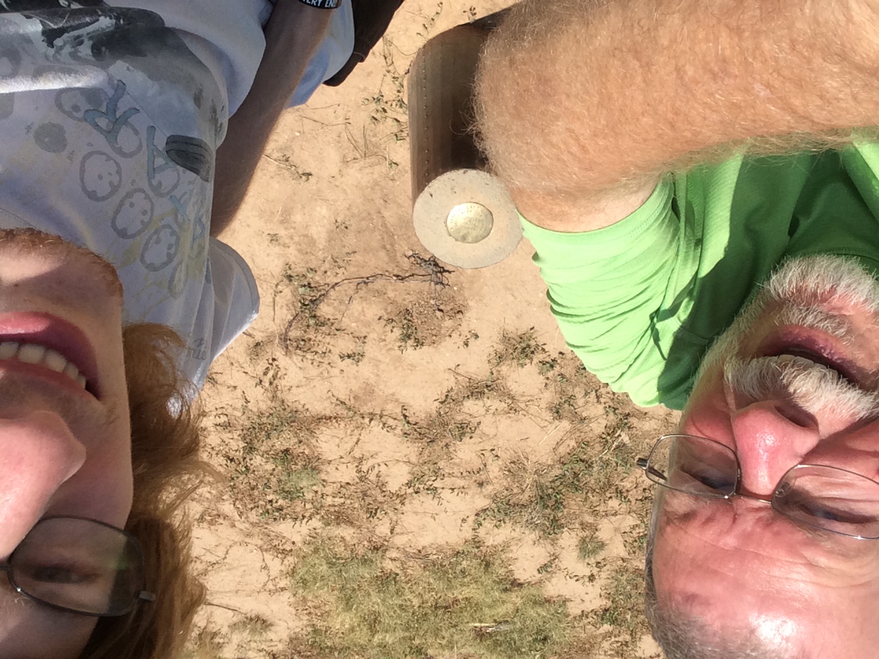
I've signed one that challenges you to find caches in 7 states in a day. It's a lot easier on the east coast than on the west coast, but this one day took us through 5, so even in the west it's possible. Start at the edge of one state, travel through 5 others and end on the edge of the next state, which is about what we did at least to get 5 different states. The photo is of the two of us getting a virtual cache at the confluence of the borders of Texas, New Mexico, and Oklahoma. Believe it or not, this was the second confluence of three states that we'd visited on this trip, having previously visited the confluence of South Dakota, Iowa, and Minnesota. Once the pandemic restrictions have totally lifted, I guess I'll need to eventually get back to the four corners area and get a photo of me there as well.

Things I learned on this day's travel. 

1. Eastern Colorado is much more part of the Great Plains than it is of the Rocky Mountains. 

2. Smart phones and time zones are remarkably accurate. There was one cache we found, where we were driving on the road into New Mexico. I parked the car at the side of the road, walked across the road to find a cache at the northwest corner of Texas. In the time I walked across the road, my smart phone had adjusted itself to Central Daylight Time (Texas) and once we walked back on the other side of the road, it had adjusted itself back to Mountain Daylight Time (New Mexico).

Tuesday, March 17, 2020

El Malpais

I still haven't covered all of my road trips from this past summer and fall, nor have I even covered all of my road trip from 2017. And so it goes. With the social distancing now in effect in the country, I have more time to deal with stuff here and not do those frivolous things like hiking and geocaching. Well, I'm still doing the former and practicing social distancing at the same time. But, on to the real subject of this particular blog.

Part of the fun of solo road trips is you can stop where ever you want to stop and explore things that might not happen if you're with other people due to a set agenda. As I was driving between Albuquerque, New Mexico and Flagstaff, Arizona on my October road trip, I spotted signs for El Malpais National Monument. I'd never been there before, so why not stop and visit?

One of the drawbacks to doing something like this however, is if you have somewhat of a set schedule, stops along the way sometimes get short circuited, because you don't have enough time to do a proper visit. This was the case with this particular stop. I basically saw some of the "greatest hits" of the monument, but really didn't get to explore it in depth. Had I had more time, I probably would have spent the night here, camping in the campground and then moved on later the next day, but I didn't have camping gear with me on this trip anyway, so the point was moot.

The park is rich in volcanic activity, with sandstone bluffs sticking out above several different lava floes in the park. There were several earth caches that I worked on during my brief stay in the park, so I learned that there were at least 7 different periods of volcanic activity across the plains as I looked out from the top of the sandstone bluffs. Much like my time at Craters of the Moon National Monument in Idaho this past summer, I could actually see the different floes, because each had a different characteristic and age to it based upon the amount of vegetation that was growing within the floe.

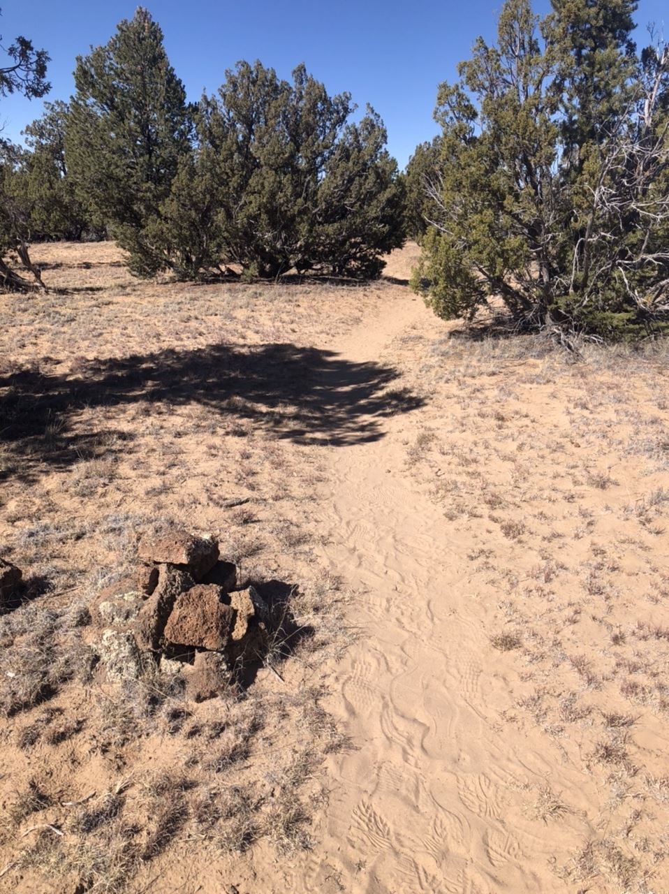
I did a couple of short hikes to viewpoints, at one point hiking along the Continental Divide Trail (CDT), one of the big three trails in the United States that run north to south. The CDT runs from the Mexican border in New Mexico all the way into Glacier National Park in Montana. Because it's a relatively new trail, unlike the Appalachian Trail (AT) or the Pacific Crest Trail (PCT), the route is not as clearly defined.  In fact, right here in the monument, there were two possible routes you could choose if you were hiking through the park along the CDT, one which went inland seen in the first photo, or the other which went along the road and was a little bit shorter. Either would count if you were hiking the trail, but if I were backpacking the trail, I think I'd opt for the part that went through the monument as opposed to along the road. In my opinion, road hiking is not that exciting.

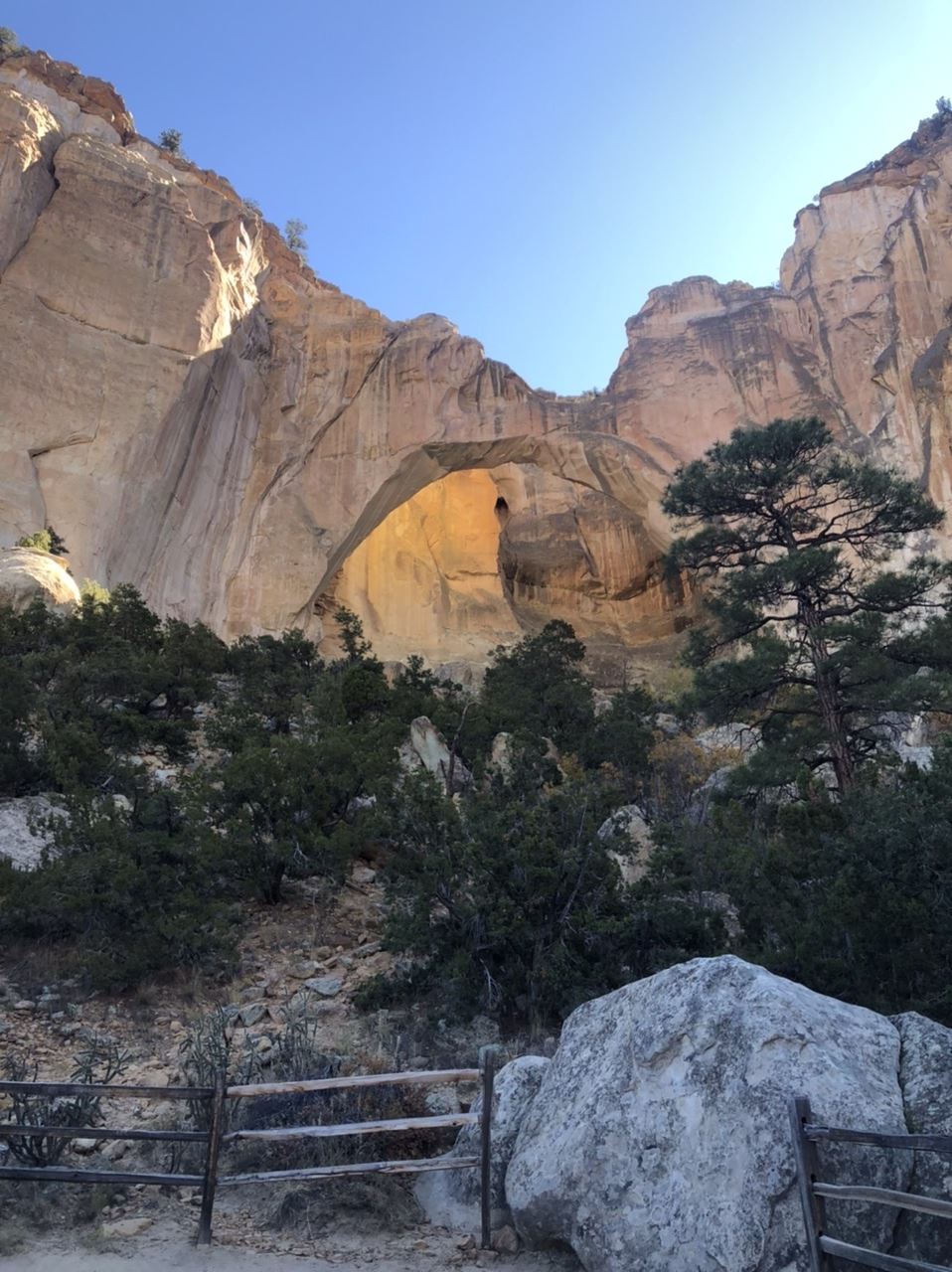
The last thing in the park I explored that day was the La Ventana Arch in the southern part of the park. La Ventana is a natural arch formed due to wind erosion. Looking at the photos I took, it's a little bit difficult to see the arch, unless you see the sunshine on the back part of the sandstone bluff behind the arch. I was there in the morning hours and the sun was not in the right place. I'm sure the view would look differently, were it later in the day and the sun was shining on the arch as opposed to in your face in the morning hours when I was there. Still, I got some pretty cool shots of the arch, one of which I'm using right now as my wallpaper on my desktop computer. Needless to say, I intend to visit the park again if I'm driving along I-40 in New Mexico. At least this time, I'll know what I'm getting into and save some extra time to explore some areas more in depth.

Many people I know who really enjoy our country's national parks, tend to forget about the smaller national monuments. That means the crowds are smaller and there's more space to enjoy the quiet solitude of a particular spot. This is definitely the case here at El Malpais. I'll be back sometime in the future.


Wednesday, November 20, 2019

Change of plans

The day following my exploration of Carlsbad Caverns and Guadalupe Mountains National Parks, I headed towards Albuquerque, New Mexico. Originally, I was going to head west toward White Sands National Monument. But when I checked the White Sands website, I saw this alert; occasionally the road into the monument can close due to missile testing. Look here for the latest information. So I checked and sure enough, the day I'm supposed to be heading to White Sands, there's going to be missile testing. The website when further to say they could give a range as to when the road would be closed, but there was no guarantee that it wouldn't last longer. 

So I now have a slight dilemma on my hands. Do I risk it and take a three hour drive on a mountainous road only to be told that the road into the park is closed? I decided that I really didn't want to rush the extra driving, so I took a different route heading northwest directly to Albuquerque. Because I got to Albuquerque earlier than anticipated, I decided to visit Petroglyph National Monument which was just a couple of miles north of my motel. I'd never heard of this particular monument before, but as long as I was there, I decided I was going to explore parts of it.

My first stop was the visitors center off of Unser Boulevard just north of Interstate 40. As a teenager, I spent many springs and summers in Albuquerque visiting my cousins who lived there, but I wasn't aware of this park at that time. This was mainly because it was established as a state park in the 70s and was authorized as a national monument by an act of Congress in 1990. I got a map and decided that I was going to explore the Boca Negra Canyon area, mainly because it looked like that was a place where the petroglyphs were easily accessible and plentiful.

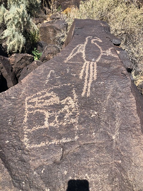
I got there at a perfect time, since most people who had been there were departing, so I had the area pretty much to myself and was able to enjoy looking at the different petroglyphs as I climbed up on the trail through the volcanic boulders that were piled up on this hillside/escarpment. After exploring that first trail, I then wandered over to the Macaw Trail, so named because of the prominent bird petroglyph right at the start of that trail. I walked that trail and figured I spent about two hours in the park before deciding to head back to my motel room for the night.

As I walked along the trails, I couldn't help but think about what might have been going through the Native American's minds as he or she scraped off the desert varnish on the rocks to create this piece of artwork. Were they trying to convey how beautiful that particular bird was, or were they merely creating an image of their food, much like what many people do today with their Instagram accounts? Also, what was going through the minds of some of the people from the present day who felt it necessary to scrape and scratch out things on the rock? As you can clearly see in the second photo, there are extra scratches that were mostly likely done by a present day visitor. Since Christianity wasn't in the area 700 to 2000 years ago when these petroglyphs were created, I know that the modern day cross I observed on one of the rocks was definitely not supposed to be there. This graffiti is pure and simple, vandalism.

And because the National Park Service is underfunded, it's not surprising that these national treasures get defaced and sometimes even stolen away. When I visited Craters of the Moon National Monument in August, there was clear evidence in several areas where lava flows had been broken off and taken home with people. It's almost like we have to lock up everything behind bullet proof cases in order to protect the treasures out there from idiots who feel that it's for them and who cares about anyone else. I was taught to look, don't touch unless it's OK to touch. I respected that rule growing up and I respect it today. Sometimes I don't get the attitude of some people. And yes, I can hear the grumpy old man in me right now yelling, "GET OFF MY LAWN!"

So I'll get off of my soapbox right now and tell you that I thoroughly enjoyed this extra highlight to my trip, one that I wouldn't have had time to see if my plans hadn't been altered in the first place. Life gave me a different thing to enjoy that day.


Thursday, November 14, 2019

Above ground next

After touring Carlsbad Caverns, I had some extra time and I really didn't want to just hole up in my motel room, so I headed south out of New Mexico into Texas towards Guadalupe Mountains National Park. Guadalupe Mountains is an extension of Carlsbad Caverns, except, this is above ground. In other words, the limestone marine fossil reef that's below ground in New Mexico, is above ground in Texas, forming the tallest mountains in the entire state of Texas.

The park is primarily a wilderness area, so there are very few roads in the park, either paved or dirt roads. Consequently, you really need to be prepared when you visit this park. The original plan was to camp here, then head up to Carlsbad Caverns and explore what I could here. As luck would have it, this would have been the only place where I would have camped on this road trip, so I opted to leave the camping gear at home and just motel it on this trip. Although the campsites are first come first served, this park has a lot of visitors in the off season because the climate is fairly mild and it would have been problematic to even find a good campsite. So it ended up being a day trip.


I explored the visitors center, took in the National Park movie they offer, then decided to explore what I could in the time I had left in the day. I actually drove out of the park further south and to the west to get some great views of El Capitan, which is the main piece of rock at the end of the exposed mountain range. I'm not sure if you can actually see Guadalupe Peak, which is the highest point in Texas, from the road. I believe the tall peak to the right of El Capitan in the sign photo is obscuring Guadalupe Peak. There is a trail leading to the top of the peak, but that's a good 8 hour round trip, so I opted for a hike in McKittrick Canyon, which is very near the northern border of Texas and southern border of New Mexico.

I ended up hiking the nature trail at McKittrick Canyon, which was a short loop trail, which was very enjoyable and allowed me to get a feel for the entire park, but if I'd had more time, I would have worked my way back up into the canyon as there was a lot to explore there. As noted above, had I camped there for a couple of extra days, I think I would have also hiked to the top of Guadalupe Peak. Eventually, I can see myself coming back here, possibly in the next five years. I'll be in somewhere in Texas in 2024 for the next solar eclipse of the sun and this might be a good starting point. Hike a day or two, then work my way down to Big Bend National Park, then further east to view the eclipse. More road trips down the road.

Friday, November 8, 2019

Going underground again

Last month, I went on an epic 10 day road trip through four states. The second day was devoted to driving from Tucson, Arizona to Carlsbad, New Mexico where I would spend the next couple of days exploring both Carlsbad Caverns National Park and Guadalupe Mountains National Park to the south in Texas. I'll write about Guadalupe Mountains in another post later on.

The drive over to Carlsbad was rather uneventful, outside of getting into town after dark and having the Jeep basically sucking on fumes. No services on the road and I'm already 100 miles in with 130 to go and the sign says, next services, 100 miles. Ok, I can make that. Yeah, well the distance approximater in the Jeep doesn't take into account hilly terrain where the gas mileage and thus the mileage range of the vehicle will go down. Going up and over the Guadalupe Mountains tested my nerve, but the Jeep made it down the north side of the Mountains and into town where I was able to fill up the tank with about a gallon of gas to spare. I could just see my wife, had she been there, but I'm glad she wasn't.


The next morning, I got to the park fairly early, as I wanted to have a lot of time to explore the cave. I'd been there one other time in, I believe, 1983, but I don't remember much of it as my friend and I went through quickly since we had other things on our mind and places to go. I had no place to go that day since this was one of my destination stops. Still, I arrived and the cave wasn't open yet, but I got in line and got my ticket (which was free because of the National Park annual pass my daughter and son-in-law bought for me as a Christmas/retirement gift). 

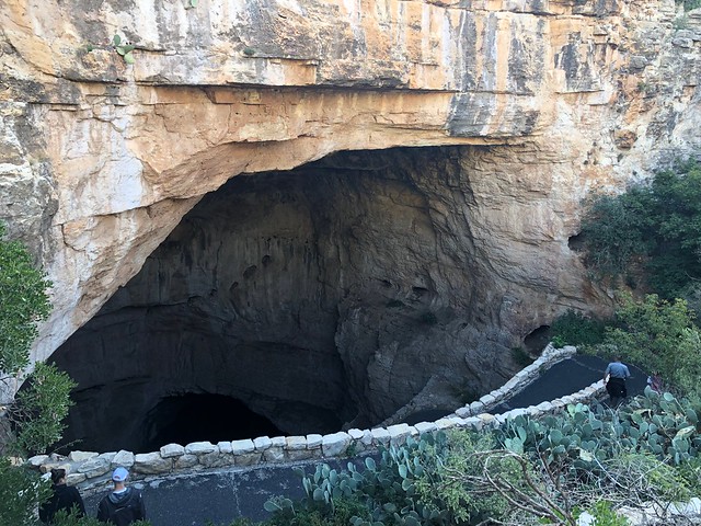
I got my phone disinfected to prevent the possibility of carrying in white nose syndrome to the bats and began my journey into the darkness. I chose to use the natural entrance as opposed to the elevator mainly because I wanted to have a more natural experience. Taking the natural entrance also allowed me to see the swallows that nest at the entrance take off in the morning. Here's a video of them I took that day

Coming into the caves is like descending an 80 story building, but mostly on a paved pathway. Many of you know that I hurt my knee back in August, so this would be a serious test of my knee, but it passed with almost flying colors. Going down is always more difficult than going up on knees and this was no exception. By the time I was down at the bottom, my knee was barking at me, but it stopped once the path leveled out.

Perhaps it was the time of year, but I remember that there didn't seem to be as much reverence of the majesty of the place the last time I was there. I'll blame that on summer tourists. I remember it being so much more crowded back then and there wasn't as much time to just look around at the immensity of the cave formations. Coming in the off season was definitely the way to go. I was able to wander the trail in a logical fashion so I could see all the main formations as well as take my time in reading the various information kiosks set up along the trail. I'm not sure I can adequately describe the enormity of the place. It's huge. To give you an idea, if you look at the second photo, the drapery seen there is probably 50 feet tall. It's very hard to see the scale of this place, but I do know that once you're down in the Big Room, it's basic layout is much like a giant cross that's larger than the Capital building in Washington, D.C.


Once I had walked the entire trail, I ended up down near the elevators and decided at that time to take advantage of them going to the surface. I think many of the cave explorers that day, did the very same thing - walk down via the natural entrance and then come back to the surface via the elevator. 80 stories in just about 2 minutes. The last photo was taken along the Big Room trail and it's called the Chinese Theater. I really like the way this photo turned out, especially with the darkness of the non-lit areas around the edges of the photo.

Once up at the surface again, I chose to wander around the visitors center for a little bit, before I headed back to the Jeep. From there, I went out to find some lunch. I'd spent the better part of three hours underground and it's really amazing how you lose your sense of time, when you don't have any reference like the sun to tell you the passage of time. After lunch, I drove south into Texas to explore the same general area, but the above ground part in Guadalupe Mountains National Park.

Thursday, October 31, 2019

Liquid

Once again, it's the end of the month, which means it's time, once again for P.J.'s monthly blogging challenge. The theme for this month was liquid. I have to be honest with this one. When I first saw the theme at the beginning of the month, I figured there would be no way that I would be able to come up with anything for the theme, let alone five shots. But, once the month got underway, I saw ways that this would work, so bear with me as I think I'm stretching the boundaries a little bit with this theme, but at least I didn't have to resort to any photos of snow. Snow? Yeah, I actually saw it snow in a city for only the second time in my entire life, but that's another story that I'll tell at another time.

I'm actually doing these in chronological order, which means this first shot was taken on October 20th. Yes, I did the entire theme in less than 10 days. At first, I thought that I might get by with 5 different cave photos, because after all, what creates a cave but water? And so I figured I was done, but I'll not post a bunch of photos of the caverns, because after all was said and done, I was able to come up with 5 different liquid shots. And to also be honest here, this blog entry is sort of a teaser for other entries I'll be writing about next month.

1. Phoenix, Arizona
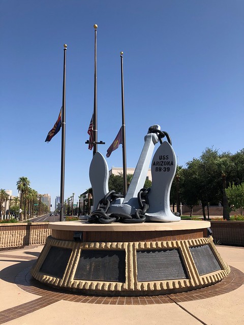
In my last post, I mentioned that I would be on an extended road trip and I just came back from that one Sunday. The main purpose of the trip was a visit to the Denver Art Museum to see a very large collection of Claude Monet paintings. The collection was only going to be there from October to February, so I figured this would be the best time to go to avoid really bad weather. Anyway, the first day of the trip took me through Phoenix. And, as usual, I spent some of the time on the drive geocaching. I ended up in downtown Phoenix, where there is a large war memorial to all of the different wars our country has been involved in. Part of this park is where I discovered the USS Arizona's anchor. Pulled from the liquid depths of Pearl Harbor in Hawaii, this anchor is on permanent display at this park in Phoenix. Around the base of the anchor are all of the names of the brave men who perished on that fateful day in 1941.

2.  Guadalupe Mountains National Park
This was a new place I'd never visited before and originally, I had planned on camping here, but things fell through on the opposite end of the trip, so I ended up staying at motels along the way. This was actually a good thing because camping was very limited in this park. The Guadalupes are the extension of Carlsbad Caverns, only above ground. I spent most of the morning exploring the Caverns, and after having thoroughly explored them, I ventured south to this national park, just across the border in Texas. This park is mostly wilderness, which means little to no roads and mostly backcountry camping and hiking, something I wasn't equipped for on this trip, but I was able to get a feel for this area nonetheless. 

West Texas is pretty much desert and the Guadalupe Mountains rise like an island out of this desert, providing refuge for an abundance of wildlife and plant life. I took this photo of this prickly pear cactus mainly because I liked the contrast of the brown and greens with the light violet of the flowers on the left. And if you're ever stuck out in the desert without water, you can, in a pinch, open up the cactus and get some liquid refreshment which will sustain you for a little bit.

3. Monet
The reason this trip happened in the first place was because of this collection of paintings. I can't remember where I first heard about this exhibition, but as soon as I knew about it, I started making plans to see it. The exhibition was falling at a perfect time: the fall and winter following my retirement. Since this exhibition was only happening during this time period, I probably wouldn't have been able to see it since I was working during most of that time. That's one of the benefits of retirement. I highly recommend it.

The main building of the Denver Art Museum is undergoing extensive renovation and the museum is in the annex building across the street. This means the collection of artwork on display is small at this time, but they had some interesting works dealing with the study of light. 

The bottom two floors of the annex were dedicated to Claude Monet and his life. Each of the patrons were given audio guides to learn more about the paintings and about different periods of his life. The galleries were arranged in approximately a chronological order. Since he created most of his lily pad and pond paintings near the end of his life, this was the last room of the gallery that I walked through. The way the liquid paint created the illusion of the liquid water in the lily pond is just amazing, in my opinion.

4. Chocolate Porter
Coming home later in the week, I ended up in Albuquerque, New Mexico. One of the nice things about traveling is checking out the local cuisine. There were times on this trip where I'd eat at a place that I was familiar with because I just wanted a quick meal and there were times when I wanted something a little bit more tasty and different. That night in Albuquerque was one such nice, so I decided to try a local barbecue place. It was recommended to me by the waitress that I try the burnt ends sandwich, a decision which I will not regret. I also have an affinity for dark, very dark beers, the kind you can almost chew. This chocolate porter certainly filled that bill and went quite well with the barbecue sandwich I had. The Nexus Silver Taproom will be someplace I will probably visit again should my travels take me through northern New Mexico.

5. Continental Divide
Finally, on my next to last day of my trip, I traveled from Albuquerque to Flagstaff, Arizona where I would spend my last night. Heading toward Denver, I missed when I exactly crossed over the continental divide, but this spot along Interstate 40 is very hard to miss. With signs on either side of the freeway, it's pretty much a spot where travelers stop and get their photos taken.

It's also the spot, where liquid falling to earth gets separated. Rain and snow falling on the eastern side of the continental divide will eventually make it to the Gulf of Mexico. In this case, the water would flow into the Rio Grande, which forms the southern border of Texas with Mexico. Rain falling on the western side would eventually flow into the Gulf of California and into the Pacific Ocean. Most of the rain that fell here would flow eventually into the Colorado River and through the Grand Canyon.


It's always intrigued me how cartographers were able to graphically map this out and figure out where each little stream would eventually drain. If you've ever looked at a map of the continental divide, you'll see some very interesting details. In southern Wyoming, it actually splits in two, creating a basin where the water doesn't flow to either, but either evaporates or flows downhill to the lowest point in that basin where it percolates back down into the groundwater. Further north, in Yellowstone National Park, there's a lake that literally sits right on top of the continental divide. The lake has two outlets, one flowing to the Atlantic Ocean and the other flowing to the Pacific Ocean.

For hiking enthusiasts, there's also the Continental Divide Trail, a national trail which loosely follows the Continental Divide from the southern border of New Mexico all the way to the northern border of Montana. Somewhere in this area, I also crossed over that trail.

And there's my interpretation of the theme liquid. Some might call this a stretch, but it worked for me. Please check out P.J.'s blog and scroll down to the bottom. You'll see other blogs and their interpretations of the same theme. And as always, feel free to comment. I won't bite.