Showing posts with label earth cache. Show all posts

Monday, June 2, 2025

Explore the World

Well, it's the first of the month again and once again, it's time for P.J.'s monthly photo blog. This time the theme is "Explore the World" and while I didn't leave the country or even the state, I did get around, so I have lots of shots to choose from for this month's theme. Without further ago, here's my take on the theme, Explore the World.

1. Reaching milestones

Part of the fun of geocaching are the goals that we attain as we play this silly game. I keep a number of goals in the back of my mind all the time just in case. Sometime back in February, someone told me that they were going to make one of their number milestones the Block Party in Elysian Park near Dodger Stadium. Geocaching has given any Mega Event (Events over 300 people attending) the chance to be a Block Party this year since it's Geocaching's 25th year of existence. The Block Party icon is different than the normal Mega event icon, which got me to thinking. I wonder if I could get my numbers to such a point that I could make the Block Party a major milestone?

I looked at my numbers and I was in a dilemma as I would either have to really slow my amount of geocaching down in order to make my 26,000th geocache find the Block Party which I plan on attending in late June up in San Jose, or pick up the pace of my geocaching and make my 26,000th fall at the Block Party happening at the beginning of May. Well, as you can see, I picked up the pace considerable, and made the Spring Fling Block Party my 26,000th find since I started back in March of 2001. In reality, it's just a number and I have many of my friends that have bigger numbers in less years and others who have less numbers in about the same number of years as I have been geocaching, but it's kind of cool to look at my geocaching profile and see the icon as 26,000. WARNING! If you click on that link, you'll be inundated by more maps and statistics that you probably thought were possible, but it'll give you a little bit of a glance into some of the things that interests me when I'm geocaching.

2. Where have you gone, Joe DiMaggio?

Another thing that interests me is walking around in cemeteries. Yeah, that might sound kind of morbid, but usually I'm there for a purpose. In this case, I was up visiting my tiny human just before Memorial Day weekend and on one of the days when she was at pre-school, I decided to visit the town of Colma, California. Colma has the distinction of most of its land being dedicated to cemeteries and the dead in town number around 1.5 million, which outnumbers the living by about 1000 to 1. This has led to Colma being called "the City of the Silent" and has given rise to a humorous motto that was featured on the city's website in the past: "It's great to be alive in Colma." I actually visited a couple of cemeteries in Colma as there were earth caches to discover and a virtual cache as well. Sometimes people will place Adventure Labs at cemeteries to allow people to discover some of the interesting aspects of that particular cemetery. I was actually doing research at Holy Cross Catholic Cemetery in order to create my own Adventure for others to discover.

When I wander around cemeteries, it's also intriguing to figure out why people ended up there as opposed to somewhere else. I know that most of the San Francisco politicians end up being buried in Colma, because there isn't any land available in San Francisco proper to be buried unless you have a plot in one of the military cemeteries there. But others make you think a little bit, for example Joltin' Joe. He was born in Martinez, California, but spent most of his adult life in New York and later Florida. Why did he choose to be buried in this particular Catholic cemetery in Colma? And it's especially intriguing since none of the rest of his family are buried there.  His brother Dom is buried in Massachusetts and his other brother Vince is buried at Ft. Bragg National Cemetery in California. But after a little digging, I figured out that both of his parents are buried in Holy Cross Cemetery in the Mausoleum, so now it makes sense.

3. Always watch where you put your feet

Coming home from Colma, I stopped in several locations to find some geocaches and I stopped in a Park n Ride just off the freeway. I pulled into the parking lot, parked the car, then got out and walked through the lot over to where the geocache was hidden. The cache wasn't hidden very well, as I could see it as I walked up and I was focused on it as I took my first step off of the pavement into the surrounding terrain. Something in the back of my mind said, "Self, have you looked to see where your feet are going to land?" So I glanced down and then pulled my foot back as I was about to step on this nice 3 foot gopher snake. Curious, it didn't seem to be the least bit interested in me and didn't flee right away, which allowed me to get several shots off, before it decided to head down a hole which was right in front of it.

So I circled around the snake, went over and found the geocache, signed the log sheet, replaced the geocache, turned around and was surprised to see the snake in the same spot, about a third of the way down the hole.  What the heck? About the time I got close, I saw the snake jerk a little bit and then I could see its body tense up. Then I understood. It had been silently waiting for that squirrel or gopher to come out of the hole and I kind of interrupted its lunch. So it went after the rodent instead. I believe it had a hold of the rodent in the hole and was slowly tensing its body in order for the rodent to expire so it could have lunch. Lots of constrictor snakes don't need to wrap their bodies around their food, they just have to maneuver them into an area where they can press against it and basically accomplish the same thing as constricting around the animal.

At that point in time, I could hear my own lunch calling my name, so I left the snake go and walked back over to the car. As I drove out of the Park n Ride, I could see the snake still partway in the hole, so I'm pretty sure that's what it was doing.

4. Zoo and Museum with the tiny human

Friday of Memorial Day weekend was a "Day with Daddy and Papa." The tiny human didn't have pre-school that day, so we decided to go down to Palo Alto to a children's museum and zoo. Meercats, giant tortoises, flamingoes, rabbits were all on display. 

There were several areas that were designed for children to view the animals in a different way, including this very large tank of African Cichlids. Of all the photos that I took of my tiny human this weekend, I believe this is my favorite of them all. She just loved looking at the fish and we stayed there quite a while until other aspects of the zoo and museum beckoned.

5. David in pieces

On the last day of the month I went geocaching with a friend of mine down in the Fullerton area. On the campus of Cal State Fullerton was a new Adventure Lab that highlighted some of the pieces of artwork that dotted the campus. One of the places the Adventure took us to was this life size replica of the statue of David, although it was in pieces, with just the feet still in the upright position. The statue was originally installed at the Forest Lawn cemetery in Cypress, California, but fell over and was damaged beyond repair during the 1987 Whittier Narrows earthquake.

Donated to the CSUF campus, it was installed in pretty much the way the statue was laying when it fell. The Adventure also went on to say that campus legend states that you will receive good luck on your finals if you rub a certain area of David. Hmmm.  I wonder what that could be?

And there you have it, my take on the theme for this month of Explore the World. Please feel free to comment. I will not bite and I read each and every comment and try to comment back on each one. Click on the link to P.J.'s page in order to see how others dealt with the same theme.


Tuesday, March 5, 2024

Exploration

It's the beginning of the month and although it's a little late, it's time for P.J.'s photo blogging challenge for the month of February. The theme this past month was Exploration. After looking at my photos that I took last month, the explore theme fell right into my lap and the tough part was picking the photos that I wanted to represent each exploration, but I narrowed them down to five and so here we go.  This is my take on the theme Exploration.

First off, I want everyone to know right now that most of this post will be about geocaching, so if you're not interested in geocaching, then feel free to stop at this point in time. All of the photos for this month's theme dealt with geocaching in one form or another, sort of.

1. Exploring Geology

The first weekend in February I took a road trip to southwestern Arizona, most particularly, Yuma, Arizona. The geocaching group down there hosts a large event on the Sunday and there's all sorts of things happening the entire weekend. One of the things I like to do when I'm on a road trip is to get as many different icons (geocaching types) as possible. One of the types that I found that weekend were five earth caches, where you learn about a geologic phenomenon of some kind, then answer some questions regarding what you've seen.

This particular earth cache is located just north of the town square in Yuma. We actually had a little time to kill before heading down to the town square for a flash mob event, so we stopped off here to study the rock and answer the questions put to us on the cache page. Most geologists that I know always carry a coin in their pockets so they can use it as a reference marker for grain size of a particular rock, hence the photo of the quarter on this rock. We ended up finding five different earth caches that weekend, not a large total, but it was enough for us with all of the other things that we explored that weekend.

2. Exploring History

One of the newer types of geocaches are the Adventures. They are kind of a cross between a multi cache and a virtual cache. We did quite a few Adventures on our way down to Yuma, mainly because it was raining all the way down there and the Adventures tend to work better, because you're looking for information, as opposed to an actual container and so you can usually get the answer much more quickly.

However, several of the Adventures that we'd chosen to do that day were quite moving and we ended up getting pretty wet in the process. One Adventure in Cathedral City had a stop at a Cancer Survivor's Park, which, for obvious reasons, was quite emotional for me. I chose not to post a photo for that one, mainly because I didn't feel a got any really good photos and so I opted to post this second photo instead.

This Adventure was in Palm Desert and explored a huge park in the city. One of the stops along the Adventure was the Desert Holocaust Memorial. This particular sculpture was right in the middle of the spot and I felt the sculptor caught the essence of the tragedy of this event. I hope I was able to convey with my photo what I felt the sculptor had already done.

3 & 4. Exploring Food

In our local geocaching community, I have a reputation of liking my food and I also have a reputation that when I say I'm hungry, that's usually the signal that we need to stop very soon and find a place to eat, otherwise "Webfoot" is going to get hangry. And hangry Webfoot is not a pleasant individual to be around. On this trip, I don't think I ever had to worry about being hangry, or even hungry because we ate well.

We were in the Palm Springs area on the first day and my daughter, when she heard that we were going to be going through Palm Springs, recommended Sherman's Deli and Bakery. The menu was extensive and I eventually settled on Sherman's Philly, with brisket, peppers, onions and provolone. Then of course, I almost had buyer's regret when I saw the man at the next table get served his Reuben sandwich. Man, that looked good, but once my sandwich came, I was all in. I guess what this really means is I need to go back there again to try the Reuben. Yeah, I can do that.

We had an asian buffet later that weekend and the last night we were there, we had fantastic Mexican food at this place that used to serve up from a Taco truck, but in the past year or so have found a brick and mortar building to serve great food. After we finished there, I mentioned that we really needed to go get some ice cream and so we ended up driving up to Mooos Creamery.

The wait was a little long, but the ice cream was worth the wait. My friend Kami had already decided when we walked into the place that she was going to sit on the ice cream bench as opposed to a booth, and so that's why we ended up there.The place had so many choices, that this is one of those places where you're going to have to go back more than once to really enjoy yourself. I had two different flavors and I could have probably chosen six or seven different ones; they all looked so good. Once we were totally satiated with that, as always, we checked our geocaching apps and realized there was a geocache right behind the building, so we walked out and around to the back of the building to score one more find before the night was done.

5. Exploring Geography

If you don't already know it, then I should tell you that I majored in Geography in college. I ended up taking a physical geography course while in community college and I was off and running from there. I'd found a subject that really interested me and I took more and more courses there and when I transferred to Humboldt State University, I continued to take courses in Geography pursuant to my degree.

I can honestly say that most of my hobbies revolve around geography in some way or another. I discovered Where's George? the dollar bill tracking web site. You enter your dollar bills, mark them in some way telling people to come to the website and then you spend your money in the hope that it will show up again. This hobby led me to Geocaching and although I still find Where's George? interesting, it's more of a passive type of hobby since you can't really control where your bills go.

Geocaching, on the other hand, you control what you do.  You want to go on a road trip to find geocaches? Go for it. You want to find urban micros? Go for it. I guess the point I'm trying to make is you can decide how your geocaching hobby works for you and that's why I like it so much more so than Where's George? I think that I like geocaching so much more because it involves all sorts of the different types of geography that I studied when I was in college, physical, historical, political, and many others.

Geography in general is a combination of different fields that sort of overlap. For instance in this last photo, we can see the physical geography of an area, what the lay of the land is doing and how those mountains in the background might be influenced by the river that you can't quite see behind me (that's an irrigation canal directly behind me). You can also see the political and human implications if you explore more deeply into this photo. I found this photo interesting from that point of view. Here I am, exploring my hobby of geocaching in Arizona, with California over my left shoulder and Mexico over my right shoulder.

And there you have it, my interpretation of the theme for this month Exploration. Please feel free to stop by P.J.'s blog and see how he and others interpreted the same theme. Please feel to comment here. I promise, I won't bite.


Sunday, March 3, 2024

Dinosaur Stew

This is a continuation of my trip to Colorado and Utah from last October. This particular day was mostly a travel day, getting myself from Grand Junction, Colorado, over to Salt Lake City, Utah where I would spend several days. When I worked out the itinerary of this trip, I realized that I was close enough to Dinosaur National Monument that it wouldn't make sense not to stop and at least whet my appetite on the fossils there, and so this particular spot also made the list of must sees. And as always, I usually bite off more than I can chew when I'm on trips like this, but it just gives me an excuse to come back at a later time.

I think if I were to do this monument up right, I'd spend several days here, probably camping. The monument has lots to offer including whitewater rafting, something that I'm not into, but I do know other people are and so I've mentioned it. For me, I was most interested in seeing the quarry of dinosaur fossils. I did not come away disappointed.

The park straddles the Utah/Colorado border and so is sort of broken up into two different unique areas. Since the quarry where the dinosaur bones can be seen close up is in the Utah side, I chose to head there. As I approached the monument border, I noticed a geocache outside the park boundary, so I decided to stop and find that one. It's very rare to find a physical geocache inside a national park area, because the National Park Service views it as litter. There are a couple of exceptions as there are several hidden in Petrified Forest National Park but they are maintained by a ranger in the park. Most geocaches you'll see in national park area would be either earth caches (geology based) or virtual caches which I've written about previously. In this case, the quarry area of the park had one of each that I was interested in finding.

I spent a good amount of time in the quarry area taking in all there was to see. The earth cache I working on asked me to examine the fossils along the wall of the quarry. It's estimated there are over 1500 fossils still embedded in the wall. I talked with a ranger and he told me that it's really more of a Dinosaur stew than anything else. The herbivores would be killed by the carnivores and the bones would be left after the carnivores had their fill. Eventually, the bones would be carried downstream where they were caught in this area by a large sand bar. Over time the bones were buried and eventually fossilized, hence the jumble of different kinds of dinosaurs all in the same area. 

The two bones you're looking at in the second photo are the femurs of a diplodocus and an apatosaurus (what we would call the brontosaurus back in the day). The photos don't really tell the tale, but both of those bones are about 6 feet in length and 18 inches in diameter.

The third photo gives more of a scale size to it. One of the tourist there was from Germany who was slightly taller than me, probably close to 6 feet tall. I asked him if he would stand near the fossil so I could get a size comparison, which he obviously obliged. This particular dinosaur, a camarasaurus, was the most common fossil found in the quarry area. This was one of the most complete camarasaurus ever found anywhere. The camarasaurus is part of the long necked dinosaurs commonly referred to as sauropods.

After taking in the quarry and finishing up the earthcache, I decided to drive further down the road to a virtual cache. I did a small hike out there to get what I needed to get and then headed back to the car and the exit so I could get to Salt Lake City in a timely fashion. I caught a little bit of rain on the drive there, but that was about all of the inclement weather that I got on this particular trip. All in all, I was very glad I stopped as this was one of those "new" places that I promised myself that I wasn't going to miss if I was in the area. It's not new anymore, but that doesn't mean I won't come back again sometime in the future.

Saturday, January 20, 2024

Black Canyon of the Gunnison


It's been awhile since I've written in here, but as I look back over the calendar of blog entries, I missed a couple of other months last year too, so now I don't feel so bad. This is a continuation of the series that I started back in October for my road trip I took in the middle of October to Colorado and Utah. 

Back in October, I wrote about my first full day in Colorado and my visit to Colorado National Monument. I had hosted a geocaching coffee event that morning, then toured the monument for most of the day afterwards. The next day, I drove southward out of Grand Junction heading for Black Canyon of the Gunnison National Park. I'd been to the park previously, before it had been upgraded to national park status, but the time gap between visits of over 50 years made me want to go back and see it again, as all I could recall of the park was that it was very vertical.

On thing that I noticed as I got to the park was that it was surprisingly busy for it being the middle of October. I figured that I'd have the park mostly to myself, with maybe some other senior citizens traveling around the country visiting sites in the "off season" but that was not the case, at least the day I was there. There were plenty of families and many of the viewpoint areas were filled to capacity with cars. 

As a kid, you don't remember things like parking problems, but I couldn't help but wonder what this would be like in the middle of summer during the height of the tourist season. And of course, my mind went back to that summer day over 50 years ago when my dad hopped us all in the station wagon for the trip north from our base camp in what I believe was Durango to visit this seldom visited national monument. Perhaps, the upgrade to national park status has boosted tourism to the place, but I still couldn't help but think that the minuscule parking lots during the summer would not be a positive experience for the average person visiting the park.

Because it was October, the park was beginning to experience multiple signs of fall with many of the park's deciduous trees and bushes showing off their fall colors. I saw photos from a national park group on Facebook that I frequent where someone posted similar photos, but had been there about 10 days later and they were even more spectacular in color than the one I've posted here. Being from Southern California, almost any color is amazing, so I guess you could say I was impressed with what I saw that day.

As I noted above, the park is very vertical. The Gunnison River carved through the volcanic rock and carved it very deep, but not very wide. At points in the park, the canyon is only about there quarters of a mile wide, but almost a half mile deep. Contrast that with the Grand Canyon in Arizona which might be a mile deep but 10 miles wide and you can see where this little canyon can be quite impressive.

As always, part of my reason for being there was to learn some geology and what better way to do that than through some of the earth caches that had been placed in the park. I did many of the tasks that were required by the different earth caches and walked several trails to get closer to the edge of the canyon. As I drove out to Painted Wall, the crowds thinned tremendously. I was actually surprised at this since I felt that the Painted Wall section was the most spectacular in the park, but it also meant that the trails were less populated and so there was time for some solitude, so I wasn't complaining.

It was also in this section where you could really see where the canyon got it name. The walls of the canyon are composed mostly of gneiss, but had bands of intruded light colored pegmatite running through them. This area is also the deepest part of the canyon. Imagine being in Paris. You could stack two Eiffel Towers on top of each other and they still wouldn't reach the top of the canyon from the river below.

I know the nostalgia of wanting to come back and retrace my childhood steps might seem silly to some, but I was glad I came. I can remember being not very impressed with my dad's photos of the park at the time and I know why now. With little to no clouds directly overhead, the sun made for very harsh lighting conditions. Lots of deep shadows so you really couldn't see a lot of detail in some of the photos and my own photos are very similar in appearance.

I enjoyed my time in the park and if I'm ever in the area again, I'll make sure I spend some more time on the opposite rim for a different perspective. There just wasn't enough time to squeeze both rims in on the same day with all the driving that entailed. After spending several hours in the park and enjoying a light lunch there, I headed back to Grand Junction, geocaching all the way back to my motel.

Tuesday, October 24, 2023

My First Full Day in Colorado

This is a continuation of my post from last week chronicling my road trip to Colorado and Utah. I pretty much took enough photos for each day, so from here on out, each day will be a different blog post to cover the entire road trip.

Usually, when I road trip and the day is primarily going to be sightseeing, it will still encompass some kind of geocaching, either earth caches or virtual caches and this was no exception. That third day, I woke up and headed off to a meet and greet coffee event that I was hosting in Grand Junction. I'd met two people the day before who were planning on attending but I wasn't sure what my turnout would be for a mid-week (Wednesday) meet and greet at 8:00 in the morning. I was pleasantly surprised when 11 people showed up for my coffee event. 

There were actually a couple of reasons why I decided to host an event mid-week. One, I enjoy meeting other geocaching people, putting names to faces of some of the caches that I'm probably going to find later during that trip. Two was a purely selfish reason. I wanted an extra cache type in Mesa County, Colorado to help me with that challenge I was working on for 6 different cache types in 20 different counties. We all had a good time at the event and then we said our goodbyes and I headed out to Colorado National Monument.

I've known about Colorado National Monument for as long as I can remember. My parents took us to Black Canyon of the Gunnison National Monument back in the early 70s, so I'm at a loss as to why they didn't drive the extra hour north to visit Colorado National Monument. Needless to say, it's been on my list of places to visit ever since and it didn't disappoint. As I approached the entry point to the park, the ranger told me that there might not be a whole lot of parking at any of the pullouts or parking lots as there was a naturalization ceremony going on at the park's amphitheater. Glad I was told ahead of time, so I made do with what I could that day, but it wasn't much of a problem. Rangers were overlooking some sketchy parking that was happening on the sides of the main road, which was understandable given the circumstances.

As I drove up the road, I pulled out several times to enjoy the view and work on a couple of earth caches. Balanced Rock, in the second photo, was one of the formations I was able to see from below. Most of the park, you're looking downwards into the valley below, but I was still working my way to the mesa above. The wind and water erosion that created this formation and others in the park will eventually destroy them as well, but that's the geologic cycle at work. 

As I continued up, I saw birds circling in the distance to the east towards Grand Junction and the town of Fruita. I came around and found another viewpoint and stopped there. There was a man viewing the birds with binoculars and I asked him if he knew what they were and he stated Golden Eagles. About five minutes later, we both spotted a Bald Eagle soaring along the ridge line. I think that's the first time I've ever seen Golden Eagles anywhere outside of a zoo and only the second time I've seen a Bald Eagle. Later in the day, I saw another Golden Eagle as it flew over my head at another viewpoint. I inquired at the visitors center later on and learned that Golden Eagles nest in the park, but Bald Eagles are rare sightings as they live and nest down in the valley near the Colorado River. I thought I was rather fortunate to experience both within five minutes of each other.

While continuing my drive along the road, I stopped at another viewpoint and got to see one of the main features of the park, Independence Monument. One of the early explorers of the area climbed to the top of this particular rock and planted an American Flag on the summit, some 450 feet above the valley floor. It's become a tradition for rock climbers to ascend the formation on July 4th and fly the flag each year.

I decided on one short hike to get out to another viewpoint, then after that headed to the visitors center to gather more information about the park. By that time, there were all sorts of parking spots as many of the people who had attended the naturalization ceremony in the morning had left. I spent another hour or so in the park, then left to find some geocaches outside of the park as I'd done all of the earth caches inside the park.

To the north of the park, I found a road that had a series of challenge caches on it and I traversed the length of that road finding all of the challenges. This was actually of particular interest to me as most of the challenges were about finding different types of caches in a certain number of counties. One of the challenges wanted me to find a multi cache in 25 different counties. A multi cache is a cache that usually has at least two different spots you have to visit in order to find the cache. Before the trip, I'd found multi caches in 24 different counties and I'd literally found my 25th county earlier that day when I found a multi cache in Grand Junction on my way to visit Colorado National Monument. I'd say that was fortuitous.

All in all, it was a very good day. I'd enjoyed myself tremendously sightseeing in the monument and then had a good time geocaching later in the afternoon. As noted above, the monument didn't disappoint and I was thrilled with all of the geology and the spectacular scenery. Eventually, I got back to my hotel room, had dinner at a nearby restaurant and had a good night's sleep. The next day would also be a big day of sightseeing somewhere else.

Wednesday, October 18, 2023

Road Trip!

This post is primarily dealing with geocaching, so if you're not interested, then you can probably stop reading right here. Things have settled down tremendously over the early part of the year where everything seemed to be upside down. In my last post which I published back in the early first week of August, I mentioned that one of my happy places was in planning road trips. This post is the first of several detailing the road trip I took to Colorado and Utah in the month of September.

The first two days of the trip were mostly traveling, getting to my first destination in Colorado, so it was primarily driving and taking breaks here and there for geocaching. Most of the geocaches that I wanted to find on this trip were either going to be virtual or challenge caches as those two were my primary focus. I would also be working on several challenge caches, including one that wanted me to find at least 6 different types of geocaches in 20 different counties. Since I had already done that in 19 different counties, I only needed one more, so I had a focus on Iron, Salt Lake, and Washington Counties in Utah, as well as Grand County in Colorado. My first night's stop was going to be in Cedar City, UT, located in Iron County, so that's where I figured I'd be able to complete that challenge.

I didn't end up getting what I needed in Iron County, since I couldn't find a particular cache near my motel, so I settled on other things that first night. One of the last caches that I ended up finding on the first day was a virtual cache in Cedar City that focused on the history of a fort that had been built there. In the morning I tried for a couple of other cache types nearby, but it just wasn't meant to be for Iron County and so I took off for Grand Junction, CO which would be my next stop.

Once again it was a full day's drive to get to Grand Junction, so there wasn't a lot of sight seeing involved, but mostly driving and stops to find geocaches. One of the stops that day involved a virtual cache which highlighted the first Olympic gold medal athlete of Utah, Alma Richards. I'm pretty sure that something like this probably wouldn't get approved in California, but I was surprised with this one since it took me literally onto the high school campus that Richards attended, onto the track, during the school day, while a physical education class was finishing up their running activity near the monument seen in the photo. No one said anything to me, no one questioned me as I walked on to campus. It was a little on the weird side to say the least since I'm used to schools being a little bit more security conscious when it comes to strangers walking onto any school campus. Anyway, I got the information I needed for the virtual and then quickly got off of campus and back on the road.

Another goal for the trip was to find at least one cache in each county I traveled through on the trip. This was a success as I only failed to find a cache in one county that I traveled through and ended up finding caches in 14 new counties. Yes, you guess it. I'd signed a challenge cache that wanted me to find caches in at least 200 counties. At the beginning of the trip, I was at 199, so Paiute County just off I-70 became my 200th county cached in and the first new one on the trip.

At a rest stop along I-70 was a great viewpoint called Spotted Wolf Canyon. There was a virtual cache here which I completed and then it was just a matter of stretching the legs a little bit. This particular canyon was amazing as it highlighted not only the view, but the engineering that went on to wind I-70 down through the canyon at a rather steep price back in the day. This spot also highlighted one of the main reasons why I've really come to enjoy geocaching so much. I've said it many times in the past, but it bears repeating. I probably would have missed this spot entirely were it not for geocaching. This silly little game has taken me to several spots that I never would have visited were it not for the game and that included spots in places like Yosemite Valley, that I felt I had explored extensively and there was no possible way that there would be something new to see in Yosemite. Geocaching proved me wrong there and it has continued to take me to awe inspiring and interesting places.

Finally, sometime further down the road that day, I ended up finding a traditional geocache. I actually found several traditionals during the day, but this one was intriguing in that when I signed it, about five signatures above it was another cacher's stamp who lives in the same area that I do. This is not the first time I've encountered things like this, but just the latest. The last time was when I encountered another local geocacher's name in a cache that I found in New Mexico. For the most part, geocachers love to travel, so this shouldn't be that surprising, but it's always cool to see friends' names in the log sheet that you've just signed.

That evening, I stopped in Grand Junction, CO which would be my base camp for the next three days or so. I did some caching in the area, actually bumped into a couple of local Grand Junction cachers who were looking for the same cache I was. When I'm on a road trip like this, I usually try to host an event somewhere just so I can meet the local geocachers. Grand Junction was no exception, so I asked them whether they were planning on attending my coffee event the next morning. They said they'd be there and then we ended up finding that cache, plus another cache nearby that had eluded them before. After finding that second cache, we said our goodbyes with the promise of seeing each other the next morning and I headed back to my motel to log my caches for the day and to get a good night's sleep. The next day promised to be a good sightseeing day for me as I was going to tour a nearby national monument, but I'll write about that in a future blog entry.

Thursday, October 6, 2022

Road Trip

Well, this one is way late in coming and I should have written some other stuff in here many months ago.  But that's water under the bridge and so seven months have gone by since I've written here. It's not like I haven't been motivated, but I just never got around to it and this has languished long enough.

So why all of a sudden am I writing today?  Well, P.J.'s photo blog challenge for this past month was the theme "Road Trip" and I did go on a road trip last month where I actually took some photos, so it made it easy to get back into the swing of things.

When I retired three years ago, I set several goals that I wanted to accomplish so it wouldn't get stagnant. One was to visit or do one new thing each year. The second was to have at least one overnighter somewhere each month. It didn't necessarily have to be a camping overnighter, but just somewhere different each month.

It was going fairly well, but then the pandemic hit and everything fell apart. But recently, I'm been getting back into the swing of those goals. And I will be the first to admit, that it's easy to come up with an excuse to take off for a long road trip.  
"Honey, I'm going up to visit the grand baby."  And so I go, although both of us went up in April for Easter, but I went up by myself to visit her in July.  June, I did a road trip up the Owens Valley on the east side of the Sierra for a lot of really good geocaching.  July, the grand baby came down here for three weeks and then we turned around and went up there for another week. Why? Because we could. August, I did another short backpacking trip in the Sierra and that brings us to this month.

I looked at the calendar and the weather forecast and it was going to be hot down here, so I decided to head up to visit the grand baby again, then head up to Lassen Volcanic National Park. I've visited this park many times in the past and seven years ago I accomplished a bucket list item by summiting Mt. Lassen in June 2015. So why go back? It's one of the least visited national parks in the lower 48 states, so there's a lot of peace and quiet, especially if you go during the week. My plan was taking me there on a Tuesday and leaving on a Friday before the weekend crowds come in. Second, because it was already mid-September, the crowds were going to be even smaller during the week, because school is back in session so there wouldn't be as many vacationers out.

Third, it's a beautiful park with some fascinating geology, plus there were a couple of new geocaches (a virtual cache and an earthcache) hidden since the last time I was there and because you know I love to go geocaching, that seemed like a no-brainer. 

My long hike day I'd set apart for myself dawned crisp and cold. Temperatures were down in the mid 30s overnight, but it warmed up nicely during the day.  I drove around the mountain and went down to the trailhead for Brokeoff Mountain, which is the second highest peak in the park at 9200 feet (2804 meters). The hike was a little bit over 3.4 miles (5.47 km) with an elevation gain of 2600 feet (792 meters). The third shot is of Brokeoff Mountain from the trail. The trail had some very nice shady spots and I had two small water crossings going up.  I ran into a total of 13 other people on the trail the entire day. Had I opted to go up to the top of Mt. Lassen instead, I probably would have encountered 3 times as many people. It was definitely a road not taken kind of adventure.

Brokeoff Mountain was my new thing for the year. In all of the years I'd been going to the park, I'd never taken that trail before. Of course, geocaching was to blame since there was the new virtual cache on the top of the mountain, which got me going. I probably would have gone to the top of Mt. Lassen again were it not for geocaching, but that's one of the reasons I really love geocaching. It takes me to a lot of places I might never have gone without it.

I'm not sure it's because of my age, or something else, but I felt like the hike up there was tougher than the hike to the top of Mt. Lassen.  Of course, I was seven years younger then, but still in my late 50s. After we got done with Mt. Lassen, my friend Craig and I then hiked out to Bumpass Hell. This time, I really wanted to go out to Bumpass Hell again, because the area really highlights the thermal features of the park, but once I got down off of the Brokeoff Mountain hike, I was pretty much spent. I headed back to my campground with no intentions of stopping elsewhere, at least to hike.

I did stop numerous times on the way back to the campground, however. Summer of 2021 was not a kind one to this park with regard to wildfires. The Dixie Fire burned about 64% of the park's eastern side and there was lots of evidence of the fire as I drove back around to my campground. In fact, the virtual cache at the top of Brokeoff Mountain had me taking compass readings of both Mt. Lassen and Mt. Shasta. As you can see by the shot of me at the top, taking a compass reading of Mt. Lassen was easy, but Mt. Shasta was more difficult to spot through the haze of not one, but two different wildfires that were between us and Mt. Shasta. Fire, it seems, is becoming more and more prevalent throughout the area.

What is really amazing, in my opinion, were the number of trees that survived the blaze.  It's not readily apparent in my last shot, but if you look closely, you can see quite a few individual trees that survived and will be the trees that help sustain this forest into the future, provided the area gets enough rain and snowfall. That being said, when I asked about weather for my trip, they said it was going to be cool at night, which I already knew and that a storm was coming, scheduled to come in Friday or Saturday. Since I wasn't planning on being around, it didn't bother me, but the forecast was for rain, with snow on the summit of Mt. Lassen.  Let's hope the area gets more of this all winter long.

And there you have it.  My road trip for September.  Please stop by P.J.'s blog and check out the links of others who posted about road trips.

Monday, November 1, 2021

Get Out and Play


Once again, it's time for P.J.'s monthly photo blog challenge, and once again, I've been remiss in not writing more here since this is literally the first post in over a month. I missed all of October, but then again, I could argue that I was following the theme of the month, which is Get Out and Play. Yeah, that's my story and I'm sticking with it. Needless to say, I went out and played this month, taking my first out of state road trip since before the pandemic hit. I hiked, I camped, I took lots of photos, so it was difficult to whittle down all the photos I took into just five shots, but I tried my best. Here are my five shots for this month.

1. A unique icon

Those of you who have been following along on this wandering that I do, know I love to geocache. One of the things that has kept me interested in the game are challenge caches - a cache that gives you a challenge to fulfill. 

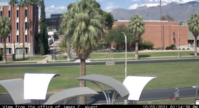
My first stop in Arizona was the Tucson area for two reasons: 1. Saguaro National Park, a place I'd never visited before and 2. The only webcam in the entire state of Arizona. Now, I know what you're probably thinking. "There's only one webcam in the entire state?" Well, there's only one webcam that's also a geocache in the entire state and it's located on the campus of the University of Arizona. So I ended up walking around campus that first day, looking for the webcam. Now usually, you'd just go to the coordinates and find the cache, but this one was a little bit trickier than that. You were told what building you needed to find, but the coordinates weren't at that particular building, but rather near a campus directory. Eventually I made my way over to where the webcam was and took a screenshot on my phone of me looking like I'm having a conversation with a fire hydrant on the university's campus.

On a side note, before smart phones, these were event tougher, because you literally had to phone a friend and have them get a screenshot on their computer. I did that here as a back up in case I wasn't able to get my own shot, but for this blog entry, I'm using my own photo. And this also gave me my 9th different icon, or type of geocache, in the state of Arizona, second only to California.

2 & 3. Saguaros

As noted above, the national park was one of my "must see" stops on my road trip to Arizona. I'm a national park enthusiast and this particular park has been on my bucket list forever. When we used to travel to Arizona to visit my uncle who lived in Scottsdale we never got as far as Tucson, but we could see saguaro cactus pretty much everywhere on the drive over to my uncle's house. They are fascinating and so the park which was a national monument at the time went on my bucket list. 

I never got to take the kids to see the park when they were growing up mainly because there's no car camping in the park, only backcountry camping. And so it sat there on my list until this past month when I decided that it was time.

I had plans to hike to a virtual geocache in the park, but the road leading up to that particular trailhead was closed while I was there, so I spent part of the morning walking a short nature trail in the park and the rest of the morning hiking on a trail in Tucson Mountain Park which is located to the east of the western portion of Saguaro National Park. The National Park is broken into two different sections, one located to the east of Tucson and one located to the west. The black and white photo, which I've entitled "The Clouds Laugh" was taken in Tucson Mountain Park while I was hiking and finding a couple of geocaches.

4 & 5. Chiricahua National Monument

My second stop on this trip was in Chiricahua National Monument in southeastern Arizona. The backstory for this park comes from a student I had probably 18 years ago. When I was teaching, my school room was always plastered with posters from various parks that I had visited or wanted to visit in the future. One day in class, this student came up to me and asked if I'd ever been to Chiricahua National Monument before. When I answered in the negative, he proceeded to tell me how beautiful the park was and what a neat place it was and he spent the better part of several class periods extolling the virtues of this park. When a 13 year old kid is that excited about something in nature, you pay attention and so this park went on my bucket list as well.

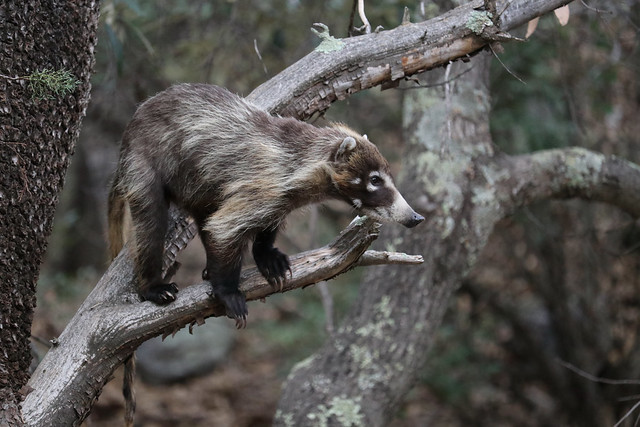
My plan was to camp here for two nights and enjoy a full day of hiking and sightseeing in the park, before heading back to Phoenix where I'd spent one more night before coming home. As I was setting up my tent at my campsite, I was interrupted by a couple of coatimundis wandering through the campground. I'd seen photos of them, but have never seen them in the wild, so this was really a thrill for me. 

These two were very skittish and took off as soon as I walked a little bit closer, so I didn't get a photos of them, but my luck definitely changed the next day as I had an entire troop of around 15 coatis wander through the river bed behind my campsite.

The troop, composed of females and youngsters wandered in the river bed and fortunately, I had my camera ready, just in case. They'd send the younger coatis up the juniper trees to pick berries and while feeding themselves up in the tree, they'd also drop berries down to the others waiting below.

Once they left, I packed up my gear and headed up to the top of the park where I'd take my hike in the Heart of the Rocks loop. My goal was to see some of the geological features of the park up close and to also get the Heart of the Rocks virtual cache there. The last photo posted here is the Pinnacle Balanced Rock and is pretty typical of the types of formations you can see in this park. 

Most of the formations are created by freeze and thaw cycles, so eventually, this particular formation will fail, but others will eventually also be created through this cycle as well. I did a second hike into an area called the grottos where the rock pillars are very close to the trail and several of the pillars have collapsed against each other. There is one point in the grotto where you can sit directly underneath a very large (garage sized) boulder being held in place by two neighboring pillars. Yeah, I sat there for a little bit.

And there you have my five photos of when I got out and played last month. Please stop by P.J.'s site and see how others got out and played last month. Please feel free to comment here. I will respond back and I don't bite. As always, thanks for dropping by.

Thursday, September 30, 2021

It's Your World

It's Your World, or more precisely, my world, which is the theme for P.J.'s monthly photo blog. I looked at the photos I took this month, and it really wasn't many, but there were enough photos that show a good portion of my world, and so without further ado, here's my world and welcome to it.

1. Geocaching

I seriously doubt that I could go an entire blog entry talking about things in my life without writing or at least, commenting on geocaching. I spent last weekend in Paso Robles, mostly geocaching, but also attending an outdoor wedding. Needless to say, I had some free time on my hands and so what better way to fill up the time than going out and finding hidden treasures using just a GPS receiver? I mean, it's better than watching football all day.

This particular shot was taken at an earth cache entitled McKittrick Oil Seep. For those of you uninitiated, an earth cache is a geocache where you learn some geology. You answer some questions about the area and hopefully see some cool geology in the process. This one was one of the better ones I've done, as it involved an oil seep similar to the La Brea Tar Pits in Los Angeles, although not nearly on the scale of the tar pits. The photo shows an oil seep at the side of the road (yes, that's oil, just coming up out of the ground). There were several other seeps on this side as well as several more on the other side of the road. There was also a seep coming up in the middle of the road just to the right of the shot. I had to watch where I was walking since I didn't want to step in any of the oil and get tar on my shoes. One of the questions I had to answer was if I could see any animals trapped in the tar. I didn't see any, but I actually have seen a mourning dove trapped in the muck at the La Brea Tar Pits, which I offered up as part of my answer for that question. 

In the past, I've done earth caches in all different kinds of area, some in caves, many out in the desert, and some at the beach. They are just another aspect of geocaching that I enjoy.

2. Hiking

My goal has been to get at least 5 miles of walking in per day as part of my daily health regimen and hiking in the hills behind my house or elsewhere happens quite frequently in the mix. At the beginning of this month, I wrote about my backpacking trip in the Sierra in August. Most hikes are not that extreme, but most will be strenuous. I want to stay in shape and live a long fruitful life.

I'm planning another geocaching/camping roadtrip next week where I'll be hiking in Saguaro National Park and Chiricahua National Monument, both of which are in Arizona. I had a student about 15 years ago ask me about Chiricahua National Monument and when I told him I'd never been there, he spent the better part of an hour extolling the beauty of that particular spot. When a 13 year old kid is that excited about something outdoors like that, you pay attention and the park has been on my radar ever since. Next week, I'm visiting, actually camping there and will also be doing some hiking.

3. Meep Meep!

Several years ago, we had a roadrunner living in the neighborhood. Apparently, it was living in the backyard of the house across the street from us. Ironically, the first day that I saw it back then, the very next day, I saw a coyote wandering down the street. Coincidence? I think not, but I digress.

Anyway, the roadrunner disappeared after a couple of months. Perhaps it had run out of lizards to eat there and so it had moved on to greener pastures. I like to think that it was just living the life in our little foothill community, enjoying what the neighborhood had to offer. Interestingly, because of the number of times I spied this particular roadrunner, I was able to hear it squawk a couple of times. No, it doesn't beep like a car as Warner Brothers would like you to believe, but I'm thoroughly convinced that the makers of the movie Jurassic Park, patterned the calls of the velociraptors in the movie after roadrunners.

Earlier this month, I was heading out on a hike and I opened our backdoor and what did I see, but this roadrunner sitting on our fence. Fortunately, I didn't spook it and I was able to quickly get my phone out of my pocket and get a couple of shots of it before it hopped the fence and then proceeded to cross the street over to our neighbor's yard. Whether this is the same roadrunner or a different one, I'm not sure but I hope to see it again. 

4. Butterflies

Over the years, there's a certain theme to my photos as I'm an avid wildlife photographer. The neighborhood birds and insects always interest me and I can usually be assured that I'll see some lizards scurrying out of the way as I walk the neighborhood. Then, in the spring and summer months, it's snake season and I'm getting a reputation as the snake whisperer.

But as always, if I can get a shot of a butterfly, I'm all over it. This American Painted Lady was flitting all around my backyard yesterday and once again, I didn't have my Canon handy, so I had to make do with the phone. Surprisingly, I was able to get quite close to this one and get some pretty good close up shots of it. This one wasn't in the best of shape, as you can see by its battered right wing, but it was holding its own quite well. I am curious since the painted lady migration that we get here in Southern California should have already happened. Did this one get knocked off course? Or is this one just a free spirit doing its own thing? This little bit of additional color in the back yard was welcome regardless of where it's supposed to be.

5. And more animals

As noted above, I enjoy taking photos of animals. If I can get the shot, I'll try to do the animal justice. Since it's getting cooler here as we've inched into fall, the snakes aren't out and about anymore, but the tarantulas have started to come out. I spotted this one a couple of days ago on one of my walks. It was just out for a mid morning walk, just like the rest of us. I grabbed a couple of shots and then thought about what I wanted to do next, so I put my foot in front of it hoping that it might crawl over my foot (yeah, I can already hear many of my friends saying out loud, "Are you nuts?").

Well, the spider didn't want to have anything to do with me, so it just stopped and we were pretty much in a stand off, but then I decided to get this shot, since it gave some scale to how large the spider was. In fact, this is actually on the small size for this type of spider, so I'm thinking this is a youngster.

And there you have it. This was my take on the them, "It's Your World" this month. Please stop by P.J.'s blog to see how other people interpreted this photo challenge and please drop a comment below.


Tuesday, August 10, 2021

Petrified Forest National Monument

Once again, it's time to look back on my youngest and my 2017 road trip to Wisconsin and back. When last we checked, we had stopped at Capulin Volcano National Monument in northeast New Mexico. The following morning, we headed off with the intention of making it into Arizona, somewhere near Petrified Forest National Park. As we drove we, of course, geocached along the way, because that's what we do.

We stopped for lunch in Albuquerque, New Mexico and then continued on to Arizona, reaching Petrified Forest sometime around 3 o'clock in the afternoon, which gave us plenty of time to tour the park. This was my second visit to the park and the first for my youngest. For those of you unfamiliar with the park, you can either enter the park at the southern end or at the northern along Interstate 40. There is no established camping in the park but there is plenty of wilderness backpacking opportunities, although you'd have to be prepared since it is a desert and water is scarce.

The park, for the most park is a drive through, something that can be seen in a couple of hours, but that doesn't diminish it in any way as a national park. The scenery is breathtaking with broad vistas in the northern part of the park. The small loop hikes take place in the southern part of the park where the concentration of petrified wood is found There's even several geocaches located within the park boundaries, which is very rare since the National Park Service views most geocaches as litter, but since these were all placed by a ranger who was stationed in the park, the park service allowed these. They even have a page dedicated to geocaching on their website. For the most part they were simple hides, but they took you to many viewpoints and points of interest within the park, without impacting the landscape in any way. Besides the traditional caches, we also found a couple of virtual caches and a couple of geological based earth caches.

Looking at the second shot, you can see in the distance, a developing thunderstorm. This would curtail a little bit of what we wanted to do, but we still were able to enjoy the park and what it had to offer. We drove through the painted desert part (northern) and stopped at all of the viewpoints, including one where there was a rusted hulk of a very old Studebacker roadster where there is a geocache hidden. Petrified Forest also has the distinction of being the only national park that the original Route 66 crosses through, which is what this viewpoint was pointing out.

After that viewpoint, you then cross over Interstate 40 and are now in the petrified forest. At every viewpoint, you get glimpses of logs, petrified with beautiful colors. As you can see in the third pooh  the colors of all of the logs were simply amazing. According to the park's website, the colors primarily come from three different minerals. "Pure quartz is white, manganese oxides form blue, purple, black, and brown, and iron oxides provide hues from yellow through red to brown." Most of the logs during this point are farther away, but you can walk out to them. Being in the high 90s, we opted to take photos and then continued on our drive, hoping to hike the Crystal Forest loop trail.

Once we got down to the Crystal Forest, we stopped and decided to hike the loop which takes you through a large portion of petrified wood and brings you very close to a lot of the logs that are preserved in the park. The temperature had cooled down considerably at this point owing to the impending thunderstorm which was approaching from the east. We kept hearing thunder in the distance and occasionally would see flashes of lightning, so we quickened our pace just a little bit. There's not a lot of cover out in the desert so the threat of a lightning strike was slightly higher, not to mention the distinct possibility that we could get rained on by a cloudburst.

I took some more photos and we finished up the loop and hurried back to our car, getting there just about the time it had started to rain. You can see the rain in the distance of the last photo as we hiked the Crystal Forest loop trail. As we walked the loop, I was struck by the immenseness of the logs, many like the one in the last photo lining the edge of the trail. I also lamented the fact that there had to be signs along the trail at regular intervals telling people that it was against the law to remove any of the petrified rock. In fact, people were encouraged to report other people who had removed pieces of petrified rock from the area. As you can see from the last photo, there's a lot of petrified wood, but if everyone took a piece every time they visited, the park would soon not have any of its namesake to even be a park anymore. If you are out and about anywhere, please practice the Leave No Trace principles as outlined on the link provided.

As noted above, you can probably see the entire park in about a couple of hours. To really delve into some of the trails, it would probably be more like four or five hours. But if you're traveling on Interstate 40, in the eastern part of the state and you're not in a hurry, this is a spot that you'll probably enjoy. I've been back a second time in October of 2019 when I was coming back from my Colorado road trip. I mainly stopped that time to find some of the geocaches that we hadn't found on the previous road trip mainly because it was really hot the day we were there. In October, I didn't have worry about heat and I was able to find the ones we'd bypassed two years previously.