Showing posts with label poison oak. Show all posts

Sunday, April 28, 2024

Bonelli Park Hike

About a week and a half ago I decided to hike the perimeter of Bonelli Park, a regional park located in my area. I decided to take advantage of the nice weather and the fact that there's free parking on the weekdays until the end of April there. There are several different trails that could have lured me in and I've hiked many of them in the past, but I decided to take the main trail around the park, the Bonelli Trail. I'd never hike the entire trail before, so some of this was going to be brand new to me. This particular trail follows fire roads around the edges of the park and sometimes the "communing with nature" is just a myth since the park borders on two major freeways in our area, Interstate 10 running east/west and Hwy 57 which runs north/south. But it was an enjoyable hike nonetheless.

I found a place to park the car down by the picnic area mainly because the trail comes very close to that point and then I started my hike there. It was here that I made my first mistake, but I really didn't think much of it until later in the day. I started out heading in a counter-clockwise direction on the trail, got about 100 yards up the trail when I realized that I hadn't turned on my Relive App on my phone. I wanted to record the entire hike as I traversed around the park. So I walked back down to the trailhead, started up the app and then decided to hike the other way along the trail in a clockwise direction around the park.

The trail from that point works its way over to the west entrance of the park and parallels Hwy 57 for a good distance. But as you can see from the first photo, there's a lot of cool, green and shady spots along the trail. In fact, most of the trail on the western side and the northern side have a lot of spots where you're hiking in the shade of large trees. You also have to be aware of poison oak as well. If you look at the bridge, the bushes growing through on the right side and then again on the left side at the other end of the bridge are all poison oak. It's not something that you'd want to bump into, but as I was walking by, I could tell that numerous bike riders had done just that, based upon some broken branches along the edges of poison oak that encroached on the trail.

On a side note, my back yard rain gauge has measured out over 23 inches of rain since January 1st of this year. Since we average 13 inches or so for an entire year, the lake that lies in the center of the park is very full. I crossed over the spillway for the dam and while no water was flowing at that time, you could tell, just by the dampness in the area that they appeared to be periodically spilling water as the snow melts in the mountains.

Needless to say, there was a lot of muddy areas of the trail, but once I got over on the east side and started heading south on the trail, it dried up considerably with the exception of this one area where I was forced to wade across this water inlet. I took my shoes and socks off and carefully waded in. The water came up almost to my knees, but it was actually rather refreshing. Getting to the other side, I put my socks and shoes back on, had a snack and then continued on with my hike.

The last several miles of the hike, which headed south and then west back to the trailhead where I started were on exposed ridges and/or low lying area with little any shelter from the sun. When I mentioned my mistake before, this was it. Had I done the hike in a counter-clockwise direction, I would have been through this part of the hike early in the day, when the sun is usually very welcome. However, later in the day, it just beat down on me and sapped my strength so my pace was much slower than usual. 

No rattlesnakes were spotted on the hike that day, although it appeared as if the weather was perfect for snakes to be out basking. I did encounter a very large gopher snake just relaxing at the side of the trail. It let me get quite close to it for a photo op and never did try to flee. I also saw a coyote ambling down the trail earlier in the hike, but just briefly, so I wasn't able to get a shot of it before it ambled off the trail and into the underbrush.

Overall, the hike was 9.1 miles with 1276 feet of elevation gain. It took me 3 and a half hours to traverse. That's a decent 2.5 miles per hour for the entire trek. I did end up stopping once for a maintenance check on one of my geocaches hidden in the park, but that probably added only about 5 extra minutes on to the entire hike. It was a good workout and one that I will probably do again, although not until the fall because the weather is heating up and it's harder to hike when it's really hot. And so it goes.

Tuesday, April 16, 2024

It's that time of year again...

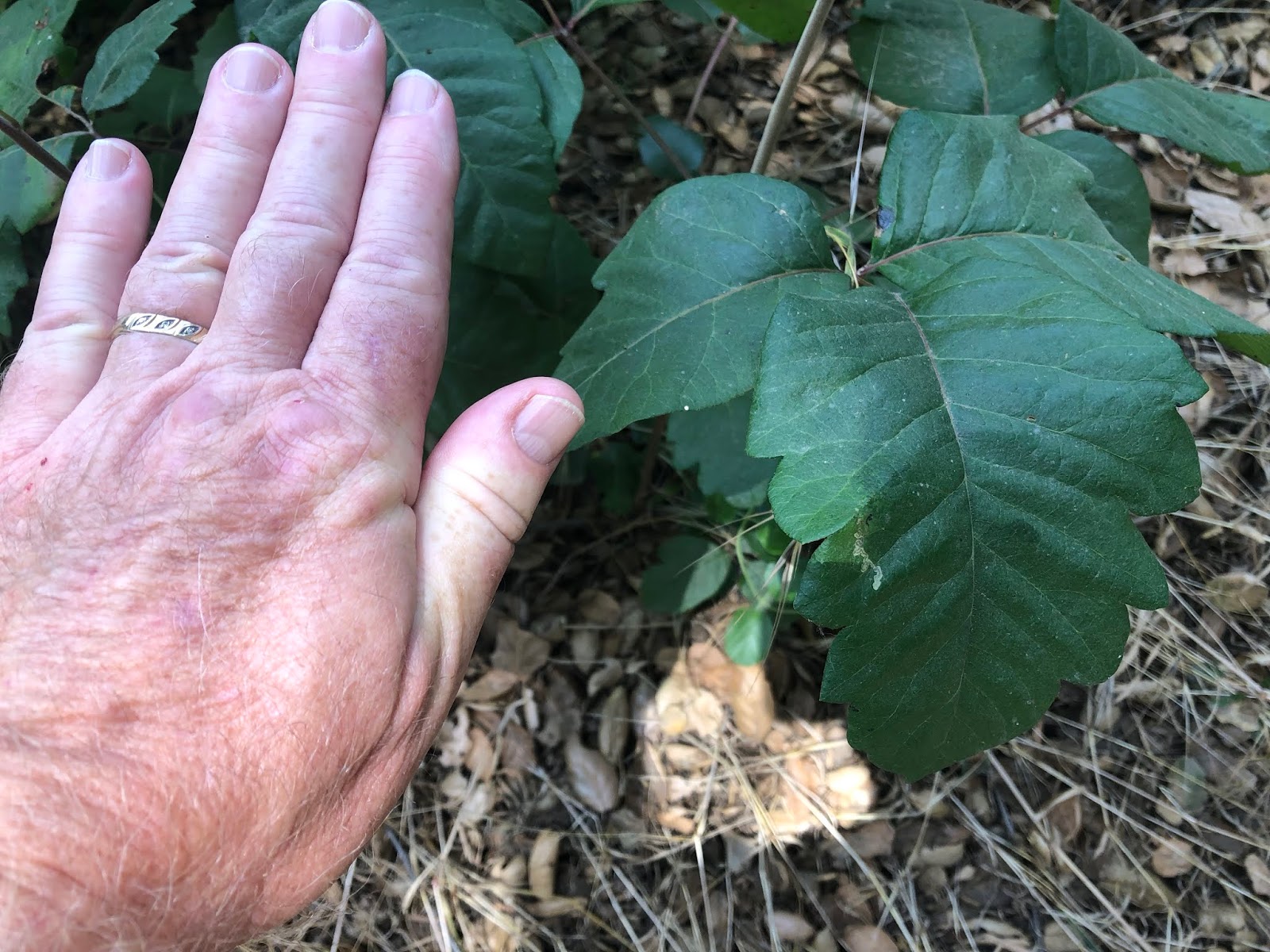
And once again, it's time for my annual public service announcement. Things are nice a green, but some of that stuff you don't want to touch. "Leaves of three, let it be." I went on a hike last week in Marshall Canyon and came across a lot of very healthy poison oak. The angle is poor in this shot, but those leaves are as big as my hand. I've seen bigger, but not by much. 

As I was walking I encountered another hiker and mentioned about the healthiness of the poison oak and he nodded. I walked up to where I wanted to go that day and then turned around and headed back to my car. The man was still there, apparently taking a nice break on his hike. As I passed he asked me whether I could point out poison oak to him. It was pretty much everywhere, intermingled with some berry bushes, so I was able to show him the difference between the two since berry bushes also have leaves of three, but also have thorns. Yeah, you never stop being a teacher I guess, but I'm happy he asked.

Also, if you're out on the trail, be ever observant for our slithery friends as well. I went looking for a geocache this morning where the cache was hidden in a large rock pile and the only hint said, "in a hole." I found a two foot long stick (probably not long enough) and probed several holes and looked around for while before calling it. The extra find is not worth it in my opinion. So I headed down the trail, got about half way down and turned a corner and there's a snake lying right in the middle of the trail. I wasn't close enough to it and fortunately, it was a small gopher snake, but it could just as easily have been a rattlesnake. The weather's warmer and they're out and about. Be careful out there my friends.


Monday, March 14, 2022

Warm Weather Means.....

Today's post is more of a public service announcement, both to you as a reader and to myself, as I've found I've gotten into some bad habits on the trail that need to be corrected now, before the warmer weather really sets in. I was out on a hike today and I literally almost stepped on this guy. As you can see, he's already been in at least one scuffle in his lifetime as he's clearly lost his tail at some point in order to escape getting eaten. Last thing he needs is to be out sunning himself and have some idiot hiker almost step on him because said hiker is too absorbed in his phone. Yeah, that would be me.

As the weather warms up, all sorts of critters are out and about again. I haven't seen a snake since last November, but that doesn't mean they're not out there, it just means I haven't seen one yet. My mindset has always been, if the lizards are active, so are the snakes. So, needless to say, this was a wake up call for me to start scanning the trail in front of me for possible hazards. Just as in driving, the phone can wait, and besides, why do I need to be looking at my phone when I'm out communing with nature?

The second thing I've noticed is an abundance of flowers starting to bloom and lots of new growth along the trail. At this point, almost all of the poison oak has started to sprout again and there's plenty of areas where it's beginning to encroach on the trail and other areas. I had to archive one of my recent geocaches that I hid, because I didn't notice the beginnings of poison oak starting to grow near where I hid the cache. Now the area is overgrown with poison oak and I don't really want other cachers to get poison oak, so I removed the cache. "Leaves of three, let it be."

Because a lot of people don't know what poison oak looks like, I tend to avoid any and all dogs on the trail during this time. It kills me, because I'm such a dog lover, but if their owners don't know what poison oak looks like, then they're probably allowing their dogs to brush up against the stuff. It doesn't hurt the dog, but the oils will get all over the fur of the dog. If you pet a dog on the trail, all of that oil is just going to get on your hands and now you have poison oak. I've had it once and trust me, you don't want to get it as the rash is pretty painful.

And one last thing. Warmer weather also brings more people to the trail. Just like in driving, stay to the right when ever possible and yield to the uphill climber. Going downhill you have all the momentum with you and you can get it back again very easily, but uphill hikers need that momentum and it takes more energy to stop and then start moving against gravity. I guess the key thing is to be courteous. We need more of that in the world anyway.

Sunday, July 14, 2019

Ice House Canyon

This past week, I went hiking with a friend up Ice House Canyon, which is a popular trailhead out of the Mt. Baldy area.  We were heading up to the Ice House Saddle, a portion of the trail that literally splits into five different trails at that point, leading to other peaks, or down into other valleys on the far side.

We got a fairly early start leaving my house around 8 in the morning and with a quick stop for a sandwich, we were at the trailhead and hiking by 8:30 in the morning.  One of the nice things about this hike is it's mostly in the shade and the temperatures are about 10 degrees cooler than what we'd experience down off the mountain, so we were hiking in the morning in about 50 degree weather.

At one point we ran into a spot where an entire boulder next to the trail was covered in ladybugs.  I've seen other areas further up and on the other side in the Lytle Creek area where I've seen the same kind of thing and it never ceases to amaze me.  Just thousands upon thousands of ladybugs.

The hike itself was very enjoyable, albeit steep.  2700 feet of elevation gain in about 3.6 miles.  I'd never hiked up to the saddle before, but I have been up on that trail several times, the last time was about a year and a half ago.

I knew my friend liked this particular hike and he kept commenting about different things on the trail to the point like he really knew all the twists and turns of the trail.  I asked him when he'd been on the trail last and his response made me laugh.  Yesterday.  Ok, that's why you're so familiar with it.

Getting up to the saddle took us a little over 2 hours and by that time, even though it was before 11 in the morning, it was time for our sandwiches.  So we found a log with the view posted here and enjoyed our lunch before we headed back down.

I will have to admit that the trail was about as slow going down too, mainly because the upper part of the trail was the only part that really resembled a simple dirt trail. Most of the trail was rocky, stair step type of trail where you have to go slowly so you don't lose your step or your balance.  It still was enjoyable, but we didn't make as good of time as would be expected since we were headed downhill.

I didn't find any geocaches along the hike, but that was not the purpose of the day.  We passed three on a side trail that I hadn't found and there were three more further up the trail from the saddle that I will have to wait for another day in which to find those.  I showed my friend one of the geocaches that I helped hide the last time I was up there.  In fact, that particular cache was named because of all the ladybugs that were in the area at that time.

I'm definitely going back, perhaps next week.  I hear some geocaches calling my name and there's also spots along the upper portion of the trail where new caches could be hidden.  I think the most surprising thing about the trail was the total lack of poison oak.  We didn't notice even one plant on our entire hike and we were in spots where you'd definitely expect to see it.  Curiouser and curiouser.

Sunday, June 30, 2019

PHOTO BLOGGING CHALLENGE (JUNE 2019): GET OUT AND PLAY

So I haven't done this in a couple of years, but since I have a new blog, I thought I'd get back into this again.  The theme was relatively easy to cover this month, since it was pretty much in my wheelhouse considering the circumstances in my life at the moment.  This month's theme was "Get Out and Play" and I did that a lot this past month.


1. Foggy morning

For readers of my other blog that haven't come over here yet, I retired at the end of May after teaching for 36 years.  I can really get out and play all the time now.  This particular photo was taken on Monday, June 3rd, the first day of my summer vacation since I don't technically retire until August 1st. The fog is actually the key to this photo.  This is a fire road loop trail in the foothills north of the town I live in in California.  This is the sunny side of the trail.  Coming down the other side you descend into a creek ravine and there's lots of trees there, so I usually just do the loop counter clockwise so I can finish in shade.  I didn't need to do that this time, but I'm really glad I did.  Hiking is one of my passions and I'm trying to build up stamina even more for longer hikes in the future. This, being the first hike of the summer, was a short hike by my standards.  But at the 2 and a half mile marker, I came upon a bear walking up a side trail.  For those of you who are familiar with this loop, this is really close to civilization, but there he was, a bear on my first day of vacation.  And, no, I was too interested in watching it that I didn't even get any photos of it.  By the time I thought about taking a shot, it was up on the ridge above the main trail, in heavy fog, behind some bushes.  Even if I had taken a photo, it would have been a grey blob.  So, you'll just have to trust me on this one.  Talking with rangers after I came down indicates that they think there's at least 3 bear up in the foothills calling this spot their home.  I've been hiking up there for the better part of 15 years and this is the first time I've seen a bear.  I probably have a better chance of seeing a rattlesnake up there, yet I haven't seen one of those either.  And so it goes.


2. Halfway through

One of my other passions is geocaching, which I do a lot.  Some people would say I'm obsessed about it.  I've been finding caches in the  wild and in the urban environments since 2001, before the hobby/sport/game was even a year old.  The nice thing about geocaching is it usually involves hiking, so I'm all over that.  Or at least getting off of your butt and out in the environment, even if it means just looking around town for things hidden then.  I prefer going out on geocaching excursions with other people.  This particular hike would have been really frustrating since we ended up with a lot of DNFs (Did Not Finds) for the day.  Eh.  That happens.  

As you can also see, I upped my mileage for this one.  Technically, this was a little less strenuous terrain-wise since it was all on paved trail, but it was definitely longer.  This was taken at mile marker 6.5 and we'd actually walked beyond that marker before we turned around and went back down the canyon we in which we were hiking.  I also hide a cache up in the canyon.  Curiously, no one has found it yet.  That is usually a rarity as there are always cachers out there who like to be First to Find on any cache, but since this particular hide is a 4 mile hike one way, it's going to take more than one cache to lure many people out there.  Had I hidden two or three caches out there, all of them might already have been found.  But just one?  I suspect it will sit there until the fall now before someone ventures out to find it.


3. Pacific Crest Trail

When I was younger, I really wanted to hike the entire Pacific Crest Trail.  I still do actually, but life is in the way.  I don't think my wife would take kindly to me taking off for five to six months to be by myself in the woods.  Although today it's probably much safer than it was 40 years ago, it's still a challenge.  The trail is 2650 miles long.  700 of that is hiking pretty much through desert landscapes.  You hike 1700 miles before you even leave California.  It's a rugged trail to say the least.

This doesn't mean I've given up on the idea, it's just on the back burner.  Right now, I've been pretty satisfied just getting out and hiking sections of it, like this one north of Big Bear Lake.  Taking a weekend backpacking trek or possibly a five day trek is not out of the realm of possibilities.  I'm sure my wife would rest easier if I went with someone else.  Any takers?


4. Checkerspot butterfly

Photography, another passion of mine has changed over the years.  I've started an Instagram account called @dogzonwalkz where I literally go out and take photos of dogs on walks and post them to my account.  Feel free to follow along there as well.

I've always enjoyed photography and this month, I went back out and started exploring other areas that I've neglected in the past, particularly, nature photography.  While out on that geocaching hike earlier in the month, we were literally swarmed by flocks of butterflies.  We counted 7 different species of butterflies as we hiked in the canyon. I didn't have my main camera with me because I was trying out some new trekking poles, plus I was geocaching, so I felt that leaving the large camera at home was the right thing to do.  All I had with me was a point and shoot and my iPhone.  This Chalcedon Checkerspot on a berry blossom was taken with my point and shoot.  There was another instance where I had a chance to get a shot of one of the other types of butterflies and I couldn't get close enough to get a shot like this since all access in was through a large patch of poison oak.  Nope, I did not want to go there, which means there's still a place for my larger camera and its big zoom lens.


5.  Muir Woods National Monument

Growing up, my dad would always take the entire family on camping trips and most of those camping trips revolved around seeing some kind of national park in the western United States.  I continued that tradition with my kids and took them to many of the places I'd been to as a kid.  I also took them to new spots, places I'd never visited or camped at previously.  Joshua Tree National Park comes to mind very quickly as one of our spring trips.  Another spring trip was to Organ Pipe Cactus National Monument.

One spot that I never visited, nor took my kids to see was Muir Woods National Monument.  I finally got to visit it when my wife and I went up to visit my daughter and son-in-law last week in the Bay Area.  We had tried to visit it last summer, but didn't realize that you need reservations for parking in the park, or to get a shuttle down to the monument and the place was sold out for the week we were there.  Once we finalized our travel plans this year, I went ahead and booked a parking reservation for the monument and we were good to go.

The park is very peaceful and despite the number of people in the park on the trails, it never felt like it was crowded, nor were the crowds disrespectful of the environment.  Most walked quietly taking in the glory of the coast redwood environment.  If people did talk, most talked in low whispers out of respect for everyone around them.  Other national park places I've been to people haven't shown the same kind of courtesy, which is why I really enjoyed myself while we were hiking along the trails.  My daughter said she enjoyed watching me just enjoy the moment.

And that's that for this month.  I hope you enjoyed these offerings to the Get Out and Play challenge set up by P.J. on his a Lil' HooHaa.  Check out some of the other photographers and how they interpreted the challenge for this month.

I apologize in advance if I don't comment back on any of your comments.  For some reason, I haven't been able to do that and if anyone else who uses Blogger can figure it out and help me out, I would greatly appreciate it.

Monday, June 17, 2019

Leaves of three, let them be

Today I went on a hike in Marshall Canyon, which is located a little northwest of me in the town of LaVerne.  I have many geocaches hidden up there and it was a nice day to walk up and check on them.

The trail is notorious for having a lot of poison oak alongside of it and it didn't disappoint today at all.  In fact, with all of the rain we've had this year, I was anticipating on seeing a lot of it.  Hillsides were covered in it and there was plenty of it on both sides of the trail, but whoever is maintaining the trail is doing a good job of keeping it at bay.  Not once, while I was hiking, did I ever feel like the poison oak was encroaching onto the trail.

However, the poison oak is very healthy.  Looking at the photo, you can tell those leaves are about the size of my hand.  They usually don't grow that large, but this has been a really good year for rain, and thus most vegetation.  I guess you can say, it's more food for the deer.

And if you guessed there's a geocache nearby, you would be right.  It's not one of mine, but to find it, you have to gingerly make your way around that particular bush, then lean out with one hand on a tree trunk to view around the other side to get the cache.  Fortunately, I didn't have to do that since I've already found that particular cache.  

I just wish other people would be more cognizant about where they put their caches so you don't possibly have people walk directly into the stuff.  I know what it looks like, but I'm sure a lot of other people don't.  It's one of the reasons I don't pet dogs on this particular trail.  It's too easy for a dog to brush up against it and transfer the oil of the plant to their fur.  Then, if you pet the dog, the oil is now on you.  Not something I'd want to get.