Showing posts with label road trip. Show all posts

Monday, September 15, 2025

The Last One

Every now and then, you just stumble upon something in your wanderings that you just have to share with others. I'm sure I've shared this with many people in the past, but I feel, now is a good time to show it again. While on my road trip last August, I ended up here. This is why I love geocaching so much. 

It's not the most scenic spot in the world, nor is it the most interesting spot, but it is the last of its kind. This Blockbuster is located in Bend, Oregon and is the only one still in existence anywhere. There's a virtual cache here, which is how I ended up here, so I have that going for me. Were it not for geocaching, I never would have seen this or known about it. I've been here. Have you?

As always, feel free to comment here.  I won't bite.

Wednesday, May 7, 2025

Sidewalks and Roads

It's the beginning of the month, which means it's once again time for P.J.'s monthly photo challenge. The theme for April was Sidewalks and Roads. For those of you who regularly read this, you know that I don't always participate in this challenge. The reason is simple. I prefer to have my photos happen organically, meaning I don't go out of my way to take photos for a specific theme, but once the month is over if I happen to have enough that I think make the theme, then I'll participate. With the theme being what it is, I was pretty sure I would have enough for this entry. And so without further ado, I present my take on sidewalks and roads.

1. New Wheels

For the past 9 years, I've been traveling around in a 2015 Jeep Cherokee. I bought it in April of 2016 and put almost 200,000 miles on it.  I would have put more but the fuel pump decided to give up the ghost at the beginning of the month and the cost of the repair, plus upcoming repairs that were due at the major mileage milestone made it not worth keeping it anymore. So we traded it in for a 2022 Subaru Forester. I've been taking it through its paces for the past month and it's really a fun car to drive. This month we drove up north to visit the tiny human, I took it out to the desert a couple of times for a little off-roading and a lot of geocaching. I thought the Cherokee had a lot of bells and whistles on it, but it doesn't compare to this one. And the nice thing is it's in my favorite color too, so I've got that going for me. 

Because the Cherokee was a white SUV, it was difficult to spot in a parking lot. The next time you go to your local Target, just look at all of the white SUVs. What I did to combat that was adding travel stickers to it.  Made it a little bit easier to spot in a parking lot. I haven't started stickering up the Forrester yet, but I'm sure I will get around to it. I have several National Park stickers that I'd like to add. And what I've heard is car stickers are much like tattoos.  You just can't stop at one.

2. Geocaching with the tiny human

Sometime just before we went north I received a video of my tiny human pointing out a geocache that's hidden in the park behind their house, saying she wanted to go geocaching with Papa when he got here for Easter. Well, that didn't happen, because of time constraints, but we did go look for this one. We'd already found it and I'd logged it on line for her. She's very proud of the fact that she has a geocaching name. Still, we had to check on this one every time we walked on the sidewalk to the park to make sure it was there. One time, she even had me check the log sheet to make sure our names were on the log sheet.  Yep, there's Papa's name, there's your name, there's the dog's name. Yes, even their dog has a geocaching account. Do mom and dad? Nope. I guess it's my responsibility to bring her up in the ways of geocaching.

3-5. Geocaching roadtrip

At the beginning of May, the Los Angeles area geocaching community had their 4th annual Mega Event in Elysian Park overlooking Dodger Stadium. It's just a big geocaching bash with my 300 closest friends. I tell you this, because I wanted to make the event my 26,000th find and so I had to do several road trips to bump my numbers up. My friend and I did a three day road trip up to Kern County to work on a couple of challenges. One was the Incorporated Cities of Kern County. It's pretty straightforward. Just find a geocache in each incorporated city in Kern County. With only 11 cities, it's very doable and so we decided to kill two birds with one stone and also work on the Cities of Kern County in a Day. Yeah, we're a little nuts, but we find these kinds of things enjoyable, so that's why we do them.

The other thing we were working on was finding some specific caches for my friend to reach the gold level and receive a geo coin at the Mega Event. We spent our first night in Ridgecrest, which is the easternmost city in Kern County. The next morning, we drove a well executed path through the cities of Ridgecrest, California City, Tehachapi, Arvin, Bakersfield, McFarland, Delano, Shafter, Wasco, Taft and Maricopa. In Taft we ended up at this monument/memorial to the oil workers of the area. There was a virtual cache here and we used that as our qualifier for the city of Taft. From there, we drove to Maricopa, found a cache there and then headed to the coast in Santa Barbara County to spend the night.

The following morning we work up to rain. Was this going to ruin the rest of the trip? Nope. By the time we were ready to leave our motel, the clouds had cleared somewhat and although we had some drizzles in the morning, we had a nice dry morning for our drive up to Pismo Beach to find some caches and some Adventure Labs. From there it was a drive down the coast with several stop along the way.

I mentioned that my friend wanted to make it to gold level for this certain challenge, so we stopped at several spots along the way to find specific geocaches that were part of this challenge. Our first stop was in Ridgecrest because he needed one of these caches from Kern County. The challenges was to find a 2025 Cache Across Southern California (C.A.S.C.) in each Southern California County and then find five more random ones anywhere. I'd already accomplished this on past trips north and south, but he needed Kern County still.

The other three that he needed were located in San Luis Obispo County, Santa Barbara County and Ventura County. We found his C.A.S.C. cache in Pismo Beach, then decided to park on the street near the pier and walk out on the pier. There happened to be a virtual cache located on the pier. Once of the requirements was to take a photo of your caching name from the pier.  Mischief managed, although I'm sure the San Luis Obispo County Fire Department thought I must have been nuts to be writing in the sand like I was near some of their equipment, but I didn't care.  I was having fun. I ended up taking an extra photo of my caching name from down below because it looked like the waves might wash the first part of my name away before I got back up on the pier. But as luck would have it, it was still perfectly intact for this shot. Nothing like taking a photo from the pier, which is pretty much an extended sidewalk.

One of our last stops in Santa Barbara County was to a virtual cache entitled Frog Shrine. I'd been here one other time where there was a different cache at the same spot, but this area has grown tremendously over the past couple of decades. When I visited it back in 2006, there were some frogs up on a low wall facing a sidewalk. Now there were frogs up on the wall, frogs down at the base of the wall and frogs on the other side of the sidewalk as well. Just an amazing collection of all sorts of frogs, some very tiny and some that were quite large as you can see from my photo. Yes, I just sat down in the middle of the sidewalk for this selfie.

After the Frog Shrine, we then headed to Ventura County to pick up one more C.A.S.C cache for my friend and then we headed home. It was not long enough in my opinion, but we accomplished everything that we'd set out to do, so it was a very successful geocaching road trip.

And there you have it: my shots taken from the sidewalks and roads where I went this past month. Please stop by P.J.'s page and read his blog and also check out some of photos of others who wrote about this challenge in their blogs. As always, please feel free to comment here.  I won't bite, I promise.


Tuesday, April 1, 2025

On to Red Bluff - Day 2 of the August 2024 road trip

Two weeks ago, I started catching you up in greater detail about my road trip up to Oregon and beyond. This is the second installment of that road trip I took last August.

I started out the day in Stockton and the original plan was to head up into Gold Country north of northeast of Sacramento. Many years ago, I'd heard about a challenge cache that wants you to find a cache hidden in every county seat in the state. While at the time, I thought that challenge was well beyond my scope, I've slowly chipped away at it over the course of the last 12 years or so and am now down to the last two county seats (Downieville in Sierra County and Quincy in Plumas County) to fulfill that particular challenge.

The problem with that plan was a major wildfire burning about 100 miles north of Sacramento. The plan was to drive into Downieville, then head to Quincy and eventually head out to Red Bluff where I would stay the night. The fire wouldn't be a problem until I wanted to head out from Quincy as it had shut down roads leading back out to the Central Valley, which would mean that I would have to completely backtrack back south to Downieville.

As I've gotten older, I've found my driving stamina isn't what it used to be. I used to think nothing of hopping into the car and heading off to college in Humboldt County, usually around a 12 or 13 hour drive with minimal stops. Yeah, that doesn't happen any longer and I've found that 6 hours of driving is usually enough for me before I'm exhausted. This side trip to get those two county seats would have been too much driving, so I opted to change my route and just head up to Red Bluff, stopping here and there along the way to grab some of the Adventure Labs that had been placed in the small towns along Interstate 5. The first Adventure took me around the campus of the University of the Pacific which is where my daughter and son-in-law went to school. I sent them this photo just to show them where I was.

Once I got to Red Bluff, I checked into my motel, then explored around the downtown area finding several geocaches.  While exploring, I found a great Mexican restaurant that had a great atmosphere and equally great food. Nothing like enjoying some local cuisine as opposed to eating at a chain restaurant.

After dinner I worked on a letterbox hybrid geocache that looked interesting just east of the restaurant. Letterbox hybrids are an offshoot of the hobby letterboxing. In letterboxing, a person is given a starting point and then follows clues in order to find the letterbox, which is similar to a geocache. There's usually a homemade stamp inside that you can use to stamp your letterboxing book. In geocaching, sometimes letterbox hybrids can be at the posted coordinates, or they can give you starting geographic position and you have to follow clues to find the cache. The only real requirement for letterbox hybrids in geocaching is that they must include a stamp in the cache container. This one was one where I had to walk down the street following the clues that had me examining the various murals that were on the sides of buildings as I walked. Eventually, it led me to the cache that I found in a back alleyway. Maybe not the best "scenic" spot in the world, but it was an enjoyable way to end my day.

Tuesday, March 18, 2025

Warmer weather means road trips

We've had a lot of rain the past couple of weeks, which has really helped our local mountains and the California Sierra Nevada mountains get that snowpack up to where it's supposed to be, but it's starting to feel like Spring is upon us and with that, warmer weather and with warmer weather comes road trips. As I look back over this blog I realized that I covered my two big road trips last year with just one blog entry each, so I'm going back to last summer and posting more detailed versions of each trip.

This first post covers the first day of my trip north to Oregon last August. Most of the day was heading north to Stockton where I would spend the night. Since most of the day was driving up the Central Valley of California and if you're at all familiar with the Central Valley, you know it can get quite boring, so I don't have many photos taken on that first day. This photo is me at a virtual geocache that I visited and logged in Bakersfield that first day.

One of the highlights of the first day was a challenge cache that I found in Atwater as I worked my way toward Stockton. It was entitled the Numbers Challenge - find 50 caches with the geocaching code (GC number) all in numbers. This isn't too spectacular, but what this cache lacked as far as a real challenge, as anyone who has over 10,000 finds probably has at least 50 caches of that requirement, it more than made up for it with its D/T rating, 3.5/4/5. 

All geocaches have a rating on them, placed by the owner and it's called a D/T rating. It can range from a 1/1 (the easiest to find) all the way up to a 5/5 (the most difficult). There are 81 D/T spots to fill and filling all the spots is called filling the Fizzy grid. That particular challenge D/T rating allowed me to quadruple up on my Fizzy grid. It was just something else to get excited about on a rather dull day of driving through the Central Valley.

I'll be posting other days of this trip in the next couple of weeks, so stay tuned for more wanderings.

Thursday, August 31, 2023

Happy Place

It's the end of the month which means it's time for P.J.'s monthly photo blog challenge. I thought about this one, then figured that I have a bunch of happy places, things or actual places that I enjoy immensely, so I thought I could make this more about all of my happy places as opposed to just one happy place. I mean, why limit yourself? And I'm sure if I really tried, I could come up with some more, but these are the ones I've chosen for this month's photos and they are in no particular order of importance.

1. It's all about planning

Right now, I'm in the middle of my second round of immunotherapy for my cancer treatment. This is a maintenance round, primarily meant for preventive care, so that's a very good thing. I had my first treatment on Monday and I have two subsequent treatments on the 5th and 12th of next month and then it appears I'll get another 3 month break. What this means in the long run is I'm planning a road trip to Utah and Colorado.

One of the things that has been really frustrating about my illness is it's not really allowed me to plan any kind of trips because I've had appointments, surgeries, and procedures that have take top priority. I get that, but with more free time, I've been able to start planning for future trips again.

I love planning road trips. I love to look at maps and guidebooks and determine what route I will take in order to fully maximize the time I have for this specific trip. This time, the plan is to head to Grand Junction, Colorado and tour Colorado National Monument and Black Canyon of the Gunnison National Park. 

I've been to Black Canyon of the Gunnison way back when I was around 13. This was actually so far in the past, the park was a national monument at the time and has since been upgraded to national park status by an act of Congress. I've never been to Colorado National Monument, but I intend to spend a day at each park and make Grand Junction my base for the three days and two nights I'm in the region. 

And I will be the first to admit that I started planning this road trip too early. I've pretty much set up my itinerary, have my hotels books and know what I want to do each day and I WANT TO GO NOW! But I can't, because of my upcoming treatments. I should have waited until next week perhaps to start planning, but you'll see later in this post that waiting might not have been a really wise choice either, because next week is going to get busy.

2. Papa and Gaga time

We didn't do this very often last year, but once I got sick, time became a little bit more precious and my daughter and son-in-law started having regular video chats with us so we could see the little one. Usually these happen around dinner time, so in essence we get to eat dinner with our granddaughter on an almost daily basis and we live 300+ miles away from each other. This is just one of the many screenshots I grabbed a couple of weeks ago when we were having dinner together.

Just watching and listening to her babble about her day, what's she's eating, her insistence on seeing our two Pooh bears that she knows are at our house, and seeing her new developments that seemingly happen on a daily basis really takes me to a happy place.

I've heard it said that being a grandparent is the best and I've probably said this more than once on this platform, but it really is. And she's coming to visit in about a week. It will be a short visit, but we are both really looking forward to seeing her and her parents.

3. The Wonders of Nature

I will never be not astounded by the wonders of nature around us. It's probably why I love to travel, to experience new things in nature to me. It also allows me to practice my art of photography and although that's developed and evolved over the years, especially with my reliance more and more with my phone as opposed to my DSLR, I still love going out and hunting down that elusive butterfly, or taking a wonderful landscape photo from some place I've visited. This particular butterfly allowed me to get my phone about two inches away from it, almost as if it knew I wasn't going to try and capture it.

My parents instilled in me a love of nature and I fully want to enjoy it for as long as I possibly can. Already in my mind, I'm planning other trips that I can take in the future. 

4. Hiking

I realize this photo isn't the greatest photo, but it really encapsulates what I enjoy about getting out in nature. I've been asked why I never took up mountain biking as it appears as if I'd be a good candidate for that particular type of exercise and recreation and I think it's mainly because I feel that biking would intrude in some of the other happy places I also like to enjoy, like photography, nature and geocaching. I mean, if you're flying by something at 20 miles per hour, by the time you stop to "smell the roses" or pursue the butterfly, the butterfly has already flown away. And so I walk, and I walk, and I walk.

Before I was retired, I was pretty much limited to hiking on the weekends. Now, I just get up, look outside and if the day looks promising, I'll put on my hiking shoes and head out to a favorite trail and enjoy the day. And what's really funny about all this is, as a school teacher, we're used to loving our summers. Now, I would honestly say that summer is my least favorite season of all. It's so dang hot that unless you get up at the crack of dawn and get out on the trail, it's usually pretty miserable out there. It's so much nicer during the cooler months of fall, winter and spring, when you can go out just about any time of the day and get a good hike in without feeling like you've been on a summer death march. Plus, now that I'm retired, I can hike any day of the week, so I don't have to exclusively go on the weekends when the trails are crowded. Nice quiet trails where I can really enjoy nature take me to a happy place.

5. Geocaching

Did you really think I could get through an entire blog post talking about happy places and not talk, at least a little bit, about geocaching? I didn't think so.

So much of the past 22 years of my life has been intertwined by this silly game that I discovered. As one of my friends, who I later introduced to this game said, "Geocaching. It's hiking with a purpose!" Although I'm not sure I agree with this sentiment entirely, I did see where he was coming from with his explanation.

And yes, part of my next roadtrip will be geocaching related. I'm actually planning on hosting two event caches while out on the trip, one in Grand Junction, Colorado and another one in Salt Lake City, Utah. What better way to meet up with other geocachers in the area than by attending an event. I looked at my itinerary and then searched to see if there were already events planned (there weren't), so I decided to host my own morning coffee events. I usually do this when I'm on a road trip, but this is the first time I've hosted two events while out on a trip. It's kind of ambitious for a 7 day trip, but I'm up to the task.

It's always enjoyable to talk with other geocachers about the game. Who knows, I might end up going caching with one of the people who show up at one of my events.

The other goal of this trip is to get the webcam caches that are in the Salt Lake City area. A webcam cache is where there's a public webcam that you need to stand in front of the webcam and either have a friend back home get a screen shot of you, or you can alternately get a screen shot of yourself off of your phone.

I've signed several challenge caches for finding webcams and since there are four different webcams in this area, it's like a goldmine for cachers working on webcam challenges. To put things in perspective, there are approximately 203 active webcam caches, so they are exceedingly rare. Webcams are no longer recognized as "real" geocaches, so these are the ones that have been grandfathered into the system. They are not getting replaced, so when one gets archived, it's gone and there's not going to be one to replace it. That's why when geocachers see there's a webcam close by, they want to get their photo taken, because you never know if that particular webcam might disappear sometime in the future. Of the 10 that I've taken a photo at, only 4 of them are still active.

And there you have it, my take on the theme Happy Place. Please stop by P.J.'s page and see how other people interpreted the same theme.  And as always, please leave a comment. I won't bite.


Thursday, September 16, 2021

Standin' on the Corner...

Well I'm a standing on the corner in Winslow, Arizona, and such a fine sight to see. It's a girl, my lord, in a flatbed Ford, slowin' down to take a look at me.

And this marks the last entry chronicling the road trip my youngest and I took to Wisconsin and back. After touring through Petrified Forest National Park, we headed to Winslow, Arizona to spend the night. Of course we geocached around town that evening including finding a virtual geocache at this spot. Memorialized in song by the Eagles, Winslow has embraced the pop culture references with a statue standing on the corner and a painting in the background making it look like there's a girl in a flatbed Ford slowing down. The building that the statue is facing plays Eagles music most of the day, although I'm not sure how late into the night the music plays. But then again, unless you really hate the Eagles, does it really matter?

Either way, it's a fun spot when you find yourself in Winslow on Route 66. The following morning, we got up, drove into Flagstaff where we had breakfast, then headed home after a very fun road trip.


Sunday, September 1, 2019

The Written Word

August has been a very enjoyable month.  For the first time in 20 years or so, I didn't go back to work in August.  Yeah, school used to start in September, but it's been opening up in August for quite a number of years.  In fact, today is my youngest's 24th birthday.  His due date was September 12th.  I was concerned at the time, because that was the first day of school for me.  Now, school begins the first week in August.  But as many of my friends know, it's not my circus, not my monkeys anymore because I retired at the end of the last school year in May.

P.J. has his monthly blog challenge and this month's challenge, for the month of August was The Written Word.  At first, I thought I wouldn't be able to put anything together, photographically for this particular month, but when I look back over my photos I took this month, I realized that I have quite a selection from which to choose.  And so it goes.

August, as noted above, was very different this year.  I actually spent time in five different states, so I've decided that each photo this month, not only should convey the theme of the written word, but should also represent each one of the different states that I spent time in this month.  I've posted on Facebook photos of signs leading into National Park sites that I visited and said, "I'm a National Park Geek."  And someone joshingly pointed out that maybe I was a sign geek.  Well, that's possible.  I love how signs sometimes give you so much information with very little words.

1.  Hiking
I like to hike, always have, always will.  I spent the month hiking a lot.  In fact, I spent a large portion of the summer hiking. One of my favorite hikes is a 5 mile loop in the Claremont Wilderness Park, a park that I didn't know even existed back in 2001.  That was the park that started me on geocaching, mainly because when I discovered geocaching, this park was where the closest geocache was hidden from my house at the time.  It was literally 7 miles away and a half mile hike.  I bought a GPS, took the boys out that Saturday and we found the cache.  We didn't walk the entire loop that time and there have been many times in the past I have not hiked the loop, mainly because I was out of shape at the time.  I'm not sure I'm in great shape now, but I do know that I'm in much better shape than I was back in 2001.  This is a good thing because I want to enjoy my retirement for as long as possible and being in good shape will help me achieve this goal.  So the written word on the sign post either tells me how far I've gone, or how far I still need to go to complete the loop.  In this case, I took it after I'd already hiked 4 and a half miles.  This was taken in California.


2.  Road trip
In the middle of the month, I took a week-long road trip through four states, just so I could feel that my routine was a little bit different for this month as opposed to most Augusts over the past years.  I grabbed Interstate 15 and took it north, traveling through Nevada and then into Arizona where the second photo was taken.  I love the color in this photo and amount of information.  
At least 7 different signs tell you a bunch of information that you need to know as you barrel your way into Arizona at 75 mph.  And no, I didn't take this photo while flying down the Interstate.  I actually did pull over and take the shot, although now that I look at it, I wonder if that would be considered emergency parking?

3.  The Golden Spike
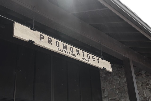
That first day, I eventually ended up in Utah.  A couple of days later, I decided that my next point of destination would be Golden Spike National Historic Site, the site where the trans-continental railroad joined the country together in May, 1869.  The country would never be the same.  Promontory, Utah was a boom town, which grew up at the site of the Golden Spike, but soon died when the railroads moved operations to a more profitable route.  I spent time time at the site watching the engines move up and down the tracks and I also got a nice hike in along the old railroad rights of way.  I say ways, because the two railroad companies literally created grades for the two lines that went by each other for 230 miles or so, mainly because they hadn't agreed upon a meeting place and they were getting paid by the mile by the United States Government.  When they finally agreed upon a meeting place that at Promontory, the grading stopped and they worked toward that point.  I also learned that the original golden spike is nowhere near Utah anymore.  
Because the Union Pacific Railroad abandoned these lines first, the Central Pacific ended up taking over this part of the rail lines and so ended up in possession of the golden spike, which is now located at Stanford University.  I guess I need to go to Stanford to complete this trip.

4. Atomic Power
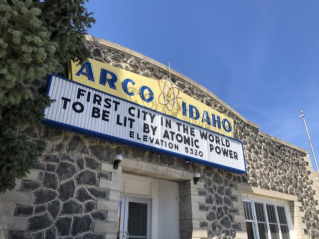
After Golden Spike, I ended up in Idaho for my next adventure.  I was going to be camping at Craters of the Moon National Monument. Taking back roads to the northeast of the monument, I ended up driving through the small town of Arco, Idaho. Now, when you think of Idaho, do you think of atomic power?  Probably not and although I was peripherally aware of Idaho's contribution to atomic power, I was not aware that Arco was the first city lit by electricity via atomic power, something that the town, obviously, is very proud of. This is one of the reasons I love road trips like this.  You stumble upon all sorts of interesting tidbits of information that you might have missed if you just flew into an area with one destination in mind. 

5. Extra Terrestrials
After camping at Craters of the Moon and also Great Basin National Park, I decided to come home. But, as a geocacher, I had to stop here.  This last shot I found at a gift shop at the beginning of the E.T. Highway which runs along SR-375 in Nevada just east of Hwy 93. It's become somewhat of a Mecca for geocachers around the world, because it's one of the major "Power Trails" in existence.  A power trail is a route set up by geocachers where there are a lot of geocaches along a specific route. Geocaches are not supposed to be closer than 528 feet apart, so a power trail typically has one every 10th of a mile for a long distance, in this case, the E.T. Highway has a geocache hidden every tenth of a mile for 200 miles.  Yeah, the math works out to 2000 geocaches.  I found the first one in the series and then turned around and continued on my way home.  At least now I can say I've geocached on the E.T. Highway.  Whether I ever get back to it or not is an entirely different story.  I have, however, signed a challenge cache near the beginning of the E.T. Highway, which challenges me to find 1000 geocaches in the state of Nevada.  With only 76 finds in the state, I have a ways to go and this power trail would help me complete that challenge.

So that completes my interpretation of P.J.'s month blog challenge, the Written Word.  Please click on the link and check out other bloggers' interpretations of the theme for this month.

Wednesday, July 31, 2019

Mt. Rushmore

This is the 4th of a series of semi-regular articles chronicling the 2017 road trip my youngest and I took to Wisconsin and back again. The next major stop on our trip was the Black Hills of South Dakota.

After Yellowstone, we drove the next morning into Grand Teton National Park. It was sort of a drive by and the weather was awful, thunder, lightning and hail and we got out of there as quickly as possible. I did get some shots, which I'll probably post later, but it's probably not worthy of a separate post. The other eventful thing that happened there was on our way out, we had to drive slowly around a downed tree that had evidently been hit by lightning probably about 15 minutes prior to us getting there.

The rest of the day was devoted to driving across Wyoming.  You don't realize how big Wyoming is until you're driving across it. I mean, it's just a big rectangle, but it just goes on and on and on. So, we ended up in Rapid City, South Dakota later in the evening. The next morning, Mt. Rushmore was on the agenda.

I've been to Mt. Rushmore previously, as an early teenager, so some of my memories have faded over time. They're in focus again. I have to say, I'm really glad we got an early start to our day and were able to make the entrance gate to the memorial right at 9:00 AM. Had plenty of parking, so we were just able to pull into the huge parking facility and park anywhere we wanted.

There were very few people around at that hour and so we walked the entrance leading up to the memorial. There are pillars on each side with the flags of all of the states of the United States on either side framing the sculpture. It doesn't get more American that this. Once out on the observation area, you have a pretty much unencumbered view and I took lots of shots. I wish there had been some clouds in the sky as I think I would have been able to have some more dramatic shots than the ones I took, which I think are pretty average.


After walking up to the viewing area, we decided to hike the Presidential Trail, which gives you different outlooks of the sculpture. I would highly recommend this trail, no matter what time of day, but the early morning hour that we took it meant that we pretty much had the trail to ourselves. We could linger and observe the sculpture without being interrupted by hordes of visitors that I'm sure walk the trail later in the day.

By the time we got back from the trail back up to the observation deck, it was probably a little bit after 10 in the morning and the observation deck was crowded, very crowded - think Disneyland type of crowds. We walked into the visitors center and walked around in there, then ended up near the entrance and decided that it was time to take our leave and head down to Custer State Park and Wind Cave National Park.

All in all, I'm glad we went. And I can't believe how lucky we actually were.  We got there at the perfect time and were able to leave at a good time to avoid the crowds. I can't imagine what the place would be like during the afternoon when the majority of people come to visit any attraction like this. I can't stress this enough.  Come as early as possible.

Monday, July 8, 2019

BASE jumping

This is the 2nd of a series of semi-regular articles chronicling the 2017 road trip my youngest and I took to Wisconsin and back again.

Our first night on the road trip was spent in Bridgeport, California.  From there, we continued north on HWY 395 into Nevada.  The purpose of that day was to find a geocache in each county along the northern tier of the state, thus giving me a find in every county in Nevada.  I already have every county covered in California and this was a natural follow up to that.  We didn't really go much out of our way since Interstate 80 cuts through all of the northern counties that I needed.  One side trip into Virginia City to get that county and it was pretty much a done deal.  We spent the night in Wells.

The next day we drove from Wells, up to Twin Falls, Idaho where we stopped for lunch near the Perrine Bridge.  The bridge's claim to fame is that it's the 8th highest bridge in the United States and it's one of the few, if not the only man-made structure in the United States, where BASE jumping is allowed year-round without a permit.  

BASE jumping. Building, Antenna, Span and Earth.  Yeah.  Jump with a parachute off of each of those things and land on the ground.  Dangerous, but apparently a lot of fun for those who want to try it.  We watched a couple of guys readying their parachutes and then decided to hang around and watch one of them jump off of the bridge.  I don't have a good video of that happening, so I'll leave this video I found on-line to show you what it's like.

All I can say is, it's not for me.


Tuesday, July 2, 2019

Manzanar

One of the things I've always written about in all of my blogs are trips that I take that I find significant.  Back in 2017, I went on a 16 state road trip with my youngest and yet, for some strange reason, never chronicled that trip in any way, shape or form, outside of some photos that I posted to Facebook. I will attempt to rectify that over the course of the next couple of months as I share some of the photography from that trip and some of the places we visited along the way.

Originally, the two of us had thought about taking a trip to Yellowstone National Park that particular summer.  We had discussed it casually in the fall of the year before but hadn't really solidified anything, so it sort of stayed on the back burner.  Then in February of 2017, my father-in-law passed away and the family had to sort out his house and deal with the things that you have to deal with when a grandparent/parent dies.  There were several pieces of artwork that my wife's sister particularly wanted. The question was how to get it back to her in Wisconsin.  That's where the idea of this 16 day road trip was spawned.

We started planning our route out and once the planning had been done, I then started looking for places we could camp each night.  It was then my son pointed out the errors of my thought process by pointing out, that with all of the extra stuff we were taking back to Wisconsin with us, we wouldn't have any room in the Jeep for camping equipment.  Yeah, I'd sort of forgotten that the Jeep is a little bit smaller than our former minivan that we'd used on previous camping trips.

So we ended up staying most of the time in motels along the way. As with all of our road trips, geocaching is involved and so there were several goals attached to that end of the trip as well.  Getting different kinds of geocaches in each state we passed through, finding a geocache in every county we passed through in Nevada.  If we played our cards right, we'd have the entire state covered at the end.

So the trip started and we drove north on Hwy 395 through the Owens Valley up the eastern side of the Sierra Nevada, stopping for lunch, stopping for gas and stopping once again at Manzanar National Historic Site. I say, once again, because every time I head north along Hwy 395, I stop there.  The historical importance of this "Relocation Center" cannot be stressed enough.  Over 110,000 Japanese Americans were relocated to 10 different camps in the Western United States during World War II, ostensibly because of their race and who we were fighting in the war.  The premise that was given by our own government was that it was for the protection of the people in the camps.  If that was the case, why were the guns pointed inward at the camps?  I'll let that sink in a little.

The first time I visited, I was 19 years old and had no idea what Manzanar was all about.  I made sure each of my children visited the place at least once.  This should never happen again in our country.  Ever.