Showing posts with label camping. Show all posts

Thursday, October 6, 2022

Road Trip

Well, this one is way late in coming and I should have written some other stuff in here many months ago.  But that's water under the bridge and so seven months have gone by since I've written here. It's not like I haven't been motivated, but I just never got around to it and this has languished long enough.

So why all of a sudden am I writing today?  Well, P.J.'s photo blog challenge for this past month was the theme "Road Trip" and I did go on a road trip last month where I actually took some photos, so it made it easy to get back into the swing of things.

When I retired three years ago, I set several goals that I wanted to accomplish so it wouldn't get stagnant. One was to visit or do one new thing each year. The second was to have at least one overnighter somewhere each month. It didn't necessarily have to be a camping overnighter, but just somewhere different each month.

It was going fairly well, but then the pandemic hit and everything fell apart. But recently, I'm been getting back into the swing of those goals. And I will be the first to admit, that it's easy to come up with an excuse to take off for a long road trip.  
"Honey, I'm going up to visit the grand baby."  And so I go, although both of us went up in April for Easter, but I went up by myself to visit her in July.  June, I did a road trip up the Owens Valley on the east side of the Sierra for a lot of really good geocaching.  July, the grand baby came down here for three weeks and then we turned around and went up there for another week. Why? Because we could. August, I did another short backpacking trip in the Sierra and that brings us to this month.

I looked at the calendar and the weather forecast and it was going to be hot down here, so I decided to head up to visit the grand baby again, then head up to Lassen Volcanic National Park. I've visited this park many times in the past and seven years ago I accomplished a bucket list item by summiting Mt. Lassen in June 2015. So why go back? It's one of the least visited national parks in the lower 48 states, so there's a lot of peace and quiet, especially if you go during the week. My plan was taking me there on a Tuesday and leaving on a Friday before the weekend crowds come in. Second, because it was already mid-September, the crowds were going to be even smaller during the week, because school is back in session so there wouldn't be as many vacationers out.

Third, it's a beautiful park with some fascinating geology, plus there were a couple of new geocaches (a virtual cache and an earthcache) hidden since the last time I was there and because you know I love to go geocaching, that seemed like a no-brainer. 

My long hike day I'd set apart for myself dawned crisp and cold. Temperatures were down in the mid 30s overnight, but it warmed up nicely during the day.  I drove around the mountain and went down to the trailhead for Brokeoff Mountain, which is the second highest peak in the park at 9200 feet (2804 meters). The hike was a little bit over 3.4 miles (5.47 km) with an elevation gain of 2600 feet (792 meters). The third shot is of Brokeoff Mountain from the trail. The trail had some very nice shady spots and I had two small water crossings going up.  I ran into a total of 13 other people on the trail the entire day. Had I opted to go up to the top of Mt. Lassen instead, I probably would have encountered 3 times as many people. It was definitely a road not taken kind of adventure.

Brokeoff Mountain was my new thing for the year. In all of the years I'd been going to the park, I'd never taken that trail before. Of course, geocaching was to blame since there was the new virtual cache on the top of the mountain, which got me going. I probably would have gone to the top of Mt. Lassen again were it not for geocaching, but that's one of the reasons I really love geocaching. It takes me to a lot of places I might never have gone without it.

I'm not sure it's because of my age, or something else, but I felt like the hike up there was tougher than the hike to the top of Mt. Lassen.  Of course, I was seven years younger then, but still in my late 50s. After we got done with Mt. Lassen, my friend Craig and I then hiked out to Bumpass Hell. This time, I really wanted to go out to Bumpass Hell again, because the area really highlights the thermal features of the park, but once I got down off of the Brokeoff Mountain hike, I was pretty much spent. I headed back to my campground with no intentions of stopping elsewhere, at least to hike.

I did stop numerous times on the way back to the campground, however. Summer of 2021 was not a kind one to this park with regard to wildfires. The Dixie Fire burned about 64% of the park's eastern side and there was lots of evidence of the fire as I drove back around to my campground. In fact, the virtual cache at the top of Brokeoff Mountain had me taking compass readings of both Mt. Lassen and Mt. Shasta. As you can see by the shot of me at the top, taking a compass reading of Mt. Lassen was easy, but Mt. Shasta was more difficult to spot through the haze of not one, but two different wildfires that were between us and Mt. Shasta. Fire, it seems, is becoming more and more prevalent throughout the area.

What is really amazing, in my opinion, were the number of trees that survived the blaze.  It's not readily apparent in my last shot, but if you look closely, you can see quite a few individual trees that survived and will be the trees that help sustain this forest into the future, provided the area gets enough rain and snowfall. That being said, when I asked about weather for my trip, they said it was going to be cool at night, which I already knew and that a storm was coming, scheduled to come in Friday or Saturday. Since I wasn't planning on being around, it didn't bother me, but the forecast was for rain, with snow on the summit of Mt. Lassen.  Let's hope the area gets more of this all winter long.

And there you have it.  My road trip for September.  Please stop by P.J.'s blog and check out the links of others who posted about road trips.

Monday, November 1, 2021

Get Out and Play


Once again, it's time for P.J.'s monthly photo blog challenge, and once again, I've been remiss in not writing more here since this is literally the first post in over a month. I missed all of October, but then again, I could argue that I was following the theme of the month, which is Get Out and Play. Yeah, that's my story and I'm sticking with it. Needless to say, I went out and played this month, taking my first out of state road trip since before the pandemic hit. I hiked, I camped, I took lots of photos, so it was difficult to whittle down all the photos I took into just five shots, but I tried my best. Here are my five shots for this month.

1. A unique icon

Those of you who have been following along on this wandering that I do, know I love to geocache. One of the things that has kept me interested in the game are challenge caches - a cache that gives you a challenge to fulfill. 

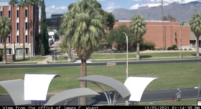
My first stop in Arizona was the Tucson area for two reasons: 1. Saguaro National Park, a place I'd never visited before and 2. The only webcam in the entire state of Arizona. Now, I know what you're probably thinking. "There's only one webcam in the entire state?" Well, there's only one webcam that's also a geocache in the entire state and it's located on the campus of the University of Arizona. So I ended up walking around campus that first day, looking for the webcam. Now usually, you'd just go to the coordinates and find the cache, but this one was a little bit trickier than that. You were told what building you needed to find, but the coordinates weren't at that particular building, but rather near a campus directory. Eventually I made my way over to where the webcam was and took a screenshot on my phone of me looking like I'm having a conversation with a fire hydrant on the university's campus.

On a side note, before smart phones, these were event tougher, because you literally had to phone a friend and have them get a screenshot on their computer. I did that here as a back up in case I wasn't able to get my own shot, but for this blog entry, I'm using my own photo. And this also gave me my 9th different icon, or type of geocache, in the state of Arizona, second only to California.

2 & 3. Saguaros

As noted above, the national park was one of my "must see" stops on my road trip to Arizona. I'm a national park enthusiast and this particular park has been on my bucket list forever. When we used to travel to Arizona to visit my uncle who lived in Scottsdale we never got as far as Tucson, but we could see saguaro cactus pretty much everywhere on the drive over to my uncle's house. They are fascinating and so the park which was a national monument at the time went on my bucket list. 

I never got to take the kids to see the park when they were growing up mainly because there's no car camping in the park, only backcountry camping. And so it sat there on my list until this past month when I decided that it was time.

I had plans to hike to a virtual geocache in the park, but the road leading up to that particular trailhead was closed while I was there, so I spent part of the morning walking a short nature trail in the park and the rest of the morning hiking on a trail in Tucson Mountain Park which is located to the east of the western portion of Saguaro National Park. The National Park is broken into two different sections, one located to the east of Tucson and one located to the west. The black and white photo, which I've entitled "The Clouds Laugh" was taken in Tucson Mountain Park while I was hiking and finding a couple of geocaches.

4 & 5. Chiricahua National Monument

My second stop on this trip was in Chiricahua National Monument in southeastern Arizona. The backstory for this park comes from a student I had probably 18 years ago. When I was teaching, my school room was always plastered with posters from various parks that I had visited or wanted to visit in the future. One day in class, this student came up to me and asked if I'd ever been to Chiricahua National Monument before. When I answered in the negative, he proceeded to tell me how beautiful the park was and what a neat place it was and he spent the better part of several class periods extolling the virtues of this park. When a 13 year old kid is that excited about something in nature, you pay attention and so this park went on my bucket list as well.

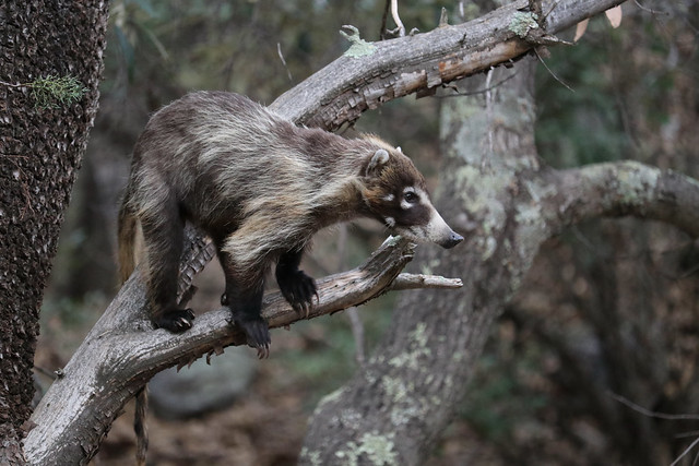
My plan was to camp here for two nights and enjoy a full day of hiking and sightseeing in the park, before heading back to Phoenix where I'd spent one more night before coming home. As I was setting up my tent at my campsite, I was interrupted by a couple of coatimundis wandering through the campground. I'd seen photos of them, but have never seen them in the wild, so this was really a thrill for me. 

These two were very skittish and took off as soon as I walked a little bit closer, so I didn't get a photos of them, but my luck definitely changed the next day as I had an entire troop of around 15 coatis wander through the river bed behind my campsite.

The troop, composed of females and youngsters wandered in the river bed and fortunately, I had my camera ready, just in case. They'd send the younger coatis up the juniper trees to pick berries and while feeding themselves up in the tree, they'd also drop berries down to the others waiting below.

Once they left, I packed up my gear and headed up to the top of the park where I'd take my hike in the Heart of the Rocks loop. My goal was to see some of the geological features of the park up close and to also get the Heart of the Rocks virtual cache there. The last photo posted here is the Pinnacle Balanced Rock and is pretty typical of the types of formations you can see in this park. 

Most of the formations are created by freeze and thaw cycles, so eventually, this particular formation will fail, but others will eventually also be created through this cycle as well. I did a second hike into an area called the grottos where the rock pillars are very close to the trail and several of the pillars have collapsed against each other. There is one point in the grotto where you can sit directly underneath a very large (garage sized) boulder being held in place by two neighboring pillars. Yeah, I sat there for a little bit.

And there you have my five photos of when I got out and played last month. Please stop by P.J.'s site and see how others got out and played last month. Please feel free to comment here. I will respond back and I don't bite. As always, thanks for dropping by.

Wednesday, September 1, 2021

Adventures

The theme for P.J.'s photo blog for this month is Adventures, and it couldn't have come at a better time, since I went on quite an adventure this past month, though not exactly as planned. But then again, that's kind of the point of an adventure in that you never know how it's really going turn out until after it's done. So here's my five photos from last month, four of which are part of my backpacking adventure and one is of something different.

1. Two striped garter snake

For those of you who have been following along, I've gotten the reputation as the snake whisperer. For whatever reason, I seem to attract snakes to me. I prefer to think that it's because I'm more observant when out walking in the wild, but that's another story that would take too long to tell here. Either way, people say it could be quite the adventure hiking with me. 

My friend Greg and I were on several training hikes up in the Lake Arrowhead and Big Bear Lake area of our local mountains. In Lake Arrowhead, we spotted a Southern Pacific rattlesnake attempting to cross the road. Fortunately, after our car straddled it on the highway, it had the sense to go back to the side of the road and I was able to get a nice video of it as it slithered into the bushes.

This garter snake, a type I've never encountered before, was stretched across the Pacific Crest Trail (PCT) when I spotted it. I was pretty content just to lay across the trail while I took some video and photos of it. I estimate it to be about 4 feet long or so, on the large side for garter snakes, but I guess it was enjoying a bountiful time eating some of the rodents out in the wild. We walked around it, I decided to take another photo from the other side, but never got the photo because I accidentally kicked a rock in the direction of the snake and it took off.

2 - 5. The big adventure

We'd hoped that the training hikes at altitude would have prepared us better for the trek ahead, but we miscalculated a little bit. This is the beginning of our hike which was supposed to be a 23 mile loop through the Cottonwood Lakes region, over New Army Pass and into Sequoia National Park. Following that, we were then going to head south on the PCT and then catch the Cottonwood Pass trail back down to our base camp near Horseshoe Meadows. We spent the first night at Horseshoe Meadows, which is slightly over 10,000 feet in elevation and then began the hike the next day.

As you can see, it looks like I'm pretty excited to head out on the trail and I'm not going to lie, I was. The adrenaline had kicked in and my pace was way too fast for the first 100 yards or so. Fortunately, my shortness of breath told me I needed to slow down, which I did and we progressed at a much more reasonable pace for the rest of the trip.

However, what you're not seeing in the first photograph is my migraine headache. Most of my migraines are caused by stress and usually when the stress is released, is when I suffer the headaches. I can't begin to tell you how many times I've had a migraine on the first day of Christmas break, the first day of Spring break and the first day of Summer vacation when I was teaching. This hike was no exception. I was stressed. As I noted in my last blog entry, this was the first time I'd been backpacking since I was 19, the week that Elvis Presley died. You can do the math, but needless to say, it had been a long time since I'd been backpacking and I was overpacked. I had way too much food and the other big thing that was weighing me down was my tent. Couple that extra weight I'm carrying with a migraine that my prescription meds are just barely blunting and it wasn't the most pleasant trip I've ever been on.

Still, we pressed on and slowly the first couple of miles were behind us. We'd entered early on, the Golden Trout Wilderness area and then progressed up the hill until we entered the John Muir Wilderness area. The next day, we were supposed to enter into Sequoia National Park, but we needed to finish out this day first. 

With the headache, at least checked for now, the hiking was a bit easier, but I had no appetite. So that meant the weight of my pack wasn't declining either. I forced down some food knowing that I needed calories in my system, but it took me the better part of an hour to eat an entire Clif Bar. If you've ever backpacked, these are snack bars designed for hiking, very dense, loaded with calories to give you energy. 

I think there was another contributing factor as well, in that we were getting smoke being blown into the area from the French Fire, which was about a hundred miles away or so. The views were rather hazy and you could smell smoke in the are. If you look at photo number 4, you can see the view from our campsite was rather hazy. I'm sure this didn't help since we were also hiking above 10,000 feet.

After setting up camp and finding a geocache at the far end of Muir Lake, we hung out at camp and discussed the next day's hike. This would have taken us up over 12,000 feet in elevation and been the longest mileage day of the hike. Neither of us were feeling really well and we made the decision that we were going to end our adventure early and head back down to Horseshoe Meadows and go home.

Some of you might say that the trip was a disappointment. Not really. I learned some valuable lessons from the trip. While my tent is an awesome tent for car camping when I'm by myself, it's too heavy for a backpacking trip, so I need to look for something that's much lighter to carry on my next trip. And there's the second thing I learned and that even though this trip was very hard, it wasn't something that would turn me off on backpacking forever. I'm looking forward to more adventures like this, perhaps even coming back here next year. 

The third thing I learned was I packed way too much food. A guy in camp told me his bear canister weighed 10 pounds for an 8 day trip. I had a 10 pound canister for a 4 day trip. Yeah, I had way too much food. And so I'll adjust.

When we got back to the car at the end of our up and back overnighter, I told my friend, "Let's remember the good things about this trip." And so I leave you with one last photo that I took that morning. The winds had shifted overnight and blew all of the smoke from the fire down the hill into Owens Valley and we were left with crystal clear views. The sun was rising, just starting to hit the tops of the peaks. The waning gibbous moon was starting to set over the same peak and the scene was magical. This is why I go on adventures like this.

As John Muir stated, "The mountains are calling, and I must go."

Please be sure and check out some other people's interpretation of the same theme on P.J.'s blog.

Friday, August 20, 2021

Some real wandering

In a couple of days, I'm going to be doing some actual wanderings, something that I haven't done in about a year and a half, since right before the pandemic shut everything down. I've been planning this trip for the past 6 months, getting everything together, taking training hikes at altitude, and keeping in shape, just so this could happen.

Next week, I start a 23+ mile backpacking trip into the Sierra Nevada out of Horseshoe Meadows trailhead. The nice thing about this trek is the most I'll be hiking on any given day is about 8 miles. Most of the days are in the 5 to 6 mile range. I haven't been backpacking since I was in college, way back in (mumble, mumble), let's just say, Elvis died the week I was backpacking in the Sierra.

Our first day, we'll hike about 5 miles up to one of the Cottonwood Lakes and find a campsite. There's actually a couple of geocaches up there, so we'll probably look for those after we set up camp. Those might be the only geocaches we find on the entire hike, but that's fine. My plan is to enjoy this, take lots of photos, and possibly put together some video blogs when I get back home.

The second day is probably our toughest day, hiking 8 miles up and over New Army pass into Sequoia National Park. Campsite is scheduled to be Soldier Lake in the park. From there, on the third day, we'll hike south, pick up the Pacific Crest Trail and follow it southbound to our next campsite. The next day, we'll complete the loop and end up back at Horseshoe Meadow. 

I'm really looking forward to this trip.

Wednesday, June 16, 2021

700 and Scenic Route & becoming a Trail Angel

Two weekends ago, I was fortunate enough to go on my first camping trip in almost 2 years. Yeah, COVID will do things like that, but I digress. Most of you who are probably reading this, have already seen my video I put together about the hike we did on that Saturday up to Kearsarge Pass. If you haven't, I would suggest clicking on that link and watching it. As we were making our way up to Kearsarge Pass, we kept bumping into Pacific Crest Trail (PCT) hikers coming down the trail heading either to Independence or Bishop for a resupply of food. I talked with several of them and made up my mind if I could help a hiker or two get down the hill the next day, I'd do it. 

The next morning, Sunday, as I packed up camp and loaded up the Jeep for the ride back home, I did a good job of Tetrising my stuff so there'd be enough room for two other backpacks and two hikers I could bring down the hill. And as luck would have it, as I was entering the hiker part of the parking lot, there stood 700 with his thumb out and I asked him how many in his group. He said one other, Scenic Route and I said "Hop in." We drove down to where Scenic Route was and the look on her face as she put her thumb out, then realized that 700 was already in the car was priceless. We loaded up her gear into the Jeep and down the hill we went.

I thoroughly enjoyed our conversation as we made our way down the hill into Independence. 700 told me that he got his trail name because that's the amount of water he carries maximum. I guess in the Sierra, that's probably OK since there's lots of water around, but hiking with only 700 milliliters of water in the desert just seemed like downright scary to me. Scenic Route got her trail name because she ended up taking several hikers down the wrong trail at some point, thus she took them on the scenic route.

I dropped them off at the corner of the road as it joined up with HWY 395, we fist bumped and I asked if I could get a photo of the two of them. Now, I wish I could have gotten a couple more shots of them, but this one will do. Scenic Route took a photo of me with 700 for her albums. I got 700's Instagram account and am now following him there, so I can see how the rest of their trip is going. We then said out goodbyes and I watched them as they headed north to get a burger at a local restaurant.

And that's how I became a trail angel.

Tuesday, August 6, 2019

A New Normalcy

Over the course of the year, there is an ebb and flow as the seasons progress throughout the year. Many of us have our ebbs and flows with our job as well. It's at this time of the year that my thoughts usually turn back to my job since the school year is starting throughout most of the country.

This year, however, as most of you are aware, that changed for me because I retired at the end of the last school year. So instead of going to my first day of school, I went on a hike today. That's the first time I haven't been at a first day of school in 36 years. Then, after I got back, my son and I went to the local REI store and I purchased a new hiking shirt, something that would wick the sweat away from my body a little bit better than my T-shirt did today.

Summertime, for me, was always a more leisurely time period. No alarms, unless I set them because I wanted to do something. Getting up a little bit later in the morning and just enjoying each day without having to rush to get things done. Now it seems like the entire year is going to be more like that.

My wife started back on her work day routine this morning, so I woke up when her alarm went off, but didn't immediately get out of bed. During our regular work week, I'd get up first, take a shower and then she'd take a shower, after I "warmed up" the bathroom. Well I didn't do that this morning, but I did eventually get up and made a pot of coffee for us to start the day.

So it's a little bit different now. Next week, instead of creating second week lesson plans for four or five different classes, I'm heading out on a camping trip into Utah, Idaho and Nevada. In October, I have a road trip planned to Denver, because there's a major exhibit of Monet paintings at the Denver Art Museum. It's only there from October to February so when, as a teacher, could I really see something like that? Now I can. 

In September, during the week, I plan on doing an over night trip to Paso Robles to see the Sensorio Paso Robles Field of Light. My hope is that I'll have something like that to do each month. I'm looking forward to new explorations and adventures. That's my new normalcy.