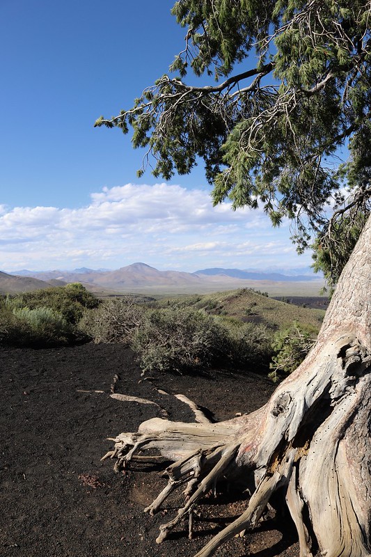
My last stop on this last road trip was Great Basin National Park. Located in eastern Nevada, it protects portion of the basin and range territory that comprises most of the central part of Nevada. One of the few glaciers in Nevada is in this park on Mt. Wheeler, which is the highest peak, at over 13,000 feet, contained solely within the state of Nevada. The park, which was created in 1986, expanded the original Lehman Caves National Monument, so there's also underground wonders here.
Nevada's Highway construction crews slowed me down quite a bit on the day I drove down to Great Basin. I probably lost an hour of time just sitting in the Jeep while road construction happened along my intended route. But, many areas talk about how they have two seasons: Winter and Road Construction. At least I wasn't adversely affected by it.
Once I got into the park, I immediately headed toward the campground, as it's first come first serve and it was late enough that it could be filling up, which is was. I think I was able to snag the next to the last campground site, but it was a nice site in my opinion. There was a small stream flowing through the center of the site, so I pitched my tent on the opposite bank. The water wasn't flowing very strong, but this site wouldn't be very ideal during high water instances, but it suited my needs perfectly for the next two nights.
The next morning, I went for a hike out to Stella Lake and then up to get as close to the glacier on Mt. Wheeler as I could. Since I was up above 10,000 feet, the air was thin, but the trail had lots of hikers on it, all enjoying the beautiful mountain air. Once I got fairly close to the glacier, I took some photos, and tried to remember back to the last time I was here about 15 years previously. That year, my two boys and I hiked a little bit closer than this shot was taken and actually walked on the glacier. I would have had to walk a lot further this year to get to the glacier because it's receded significantly over time. It's estimated that if current conditions continue to prevail, the glacier will be gone in the next 20 years. That's sad to think about.

After getting back from my hike, I then purchased a ticket for an underground tour of Lehman Caves. There are typical formations in this small cave. Stalactites hold tight to the ceiling, while stalagmites, might reach the ceiling. The cave, however, is most famous for its shield formations. These shields are two disks with a thin layer of water in between them. The water drips along the edges forming the cave formations. Carlsbad Caverns, in New Mexico has a grand total of 2 shields in the entire cave. Lehman Caves have over 300 shields and it's a tiny cave system compared to Carlsbad Caverns.
The park service is, at the same time, trying to combat White Nose Syndrome, which is a fungal infection that is fatal to bats. It's very contagious and has killed millions of bats in the eastern United States over the past 5 years. It has been identified in California, but no bats have been affected yet in this state, but the fungus has been found on brown bats in the state of Washington.
The rangers were relying on the honor system, but I felt that the people who were entering the caves were abiding by the rules set out. I have been in a cave in Idaho, so I had to disinfect my iPhone since I took it into the cave. I brought a second set of shoes on this camping trip, so I just wore the other shoes for this tour. They had ammonia baths for shoes if you didn't have a second pair to wear in the cave. Soak the soles for five minutes and you'll be okay.
Next week, my plan is to be in Carlsbad Caverns. I know I'm going to have to disinfect my phone again, but since then and now, I've purchased a new pair of shoes, so I'll be good to go for this trip. Hopefully, this infection will not spread much beyond where it is located now.
There are a variety of things that I enjoy about road trips. Visiting places again to rekindle the enjoyment that I had the first time around is one of them, but I think visiting new areas and exploring things I haven't seen before is even more exciting. That's one of the reasons why I decided to visit Craters of the Moon National Monument on my first road trip this summer.
The park, which is located in Idaho, has been on my radar (bucket list) for quite some time. My time in Idaho, previously, had been limited and I'd never gotten this close to the monument before, although I suppose you could argue that my youngest and I could have stopped there while heading up to Yellowstone National Park, but I guess the lure of the geysers was stronger than the lure of the lava fields. This trip, Craters of the Moon was going to be one of the central pieces of the trip, one where I'd spend a longer period of time to really explore the park.
I got there early in the afternoon, since I only had to drive from Pocatello, Idaho. While on the drive, I stopped here and there to find some geocaches, but I wanted to get to the park early in order to secure a good camping spot. First come, first serve sites area always unpredictable. Many times previously, when I'd visited Cedar Breaks National Monument, I had my pick of the campground, but this trip when I stopped there, the campground was almost full. Needless to say, I wanted to make sure I had a campsite.
The campground is one of the coolest campgrounds I've ever encountered in a national park or monument. I believe the park service just literally bulldozed spots out in the middle of this huge lava field. Many were very secluded, with high rock walls all around, which was very important, as those rock walls cut the wind that whipped through the campground and park during the day.
I got a pretty nice campground and then went around and explored what I could that afternoon. I drove outside of the visitors center area over to an overlook that gave me an incredible view of the lava fields that formed the park. From this vantage point, it was very easy to see the different fields and to tell which were older, based upon the size and amount of the vegetation. The older fields had Limber Pines growing, while younger fields had small sage and plants, or perhaps very little at all.
I then came back into the main area of the park and drove the loop drive, stopping at pullouts here and there to work on several earth and virtual caches that were present in the park. The virtual cache took up the most time because it wanted me to get information from different points around the park, so I decided to concentrate on that. Even so, as I worked on one part of that cache, I ended completing another earth cache which was located at the top of a huge cinder cone in the middle of this particular area.
The views from the top of that cinder cone were amazing as you can see from the second photo. I actually went back and forth with myself whether I wanted that second photo to be in color or black & white, but as you can see the color side won out. Whenever I take landscape shots, I always look at them as to whether they'll look good in black & white, mainly because I'm a big fan of Ansel Adams' photography.
Finally, after a good afternoon of exploring, I went back to camp, ate dinner and walked around the campground marveling at all the stars I could see in the night sky. Many of the parks in this area of the country have been designated "Dark Skies" parks, because of their remoteness to city lights. Few of us ever see many of the stars in the night sky anymore due to light pollution, so it's always nice to get out in an area where you can see the Milky Way galaxy at night. Unfortunately, I couldn't see the Milky Way for very long, since I happened to be there during the full moon cycle for the month and the moon, once it rose, pretty much washed out much of the sky.

The next day was spent exploring the far reaches of the loop drive and areas I hadn't been able to get to the previous day. I went on several hikes, including the tree molds trail, where I got some nice landscape shots and was able to see some tree molds created by the lava flowing around trees and preserving their outlines. I also got to see where the lava fields stopped flowing near some splatter cones. One splatter cone was called Snow Cone, because it had a large snow dome down inside of it.
That evening, I was treated to a spectacular sunset. After dinner, I decided to head out to one of the parking lots on the loop drive so I would have a large expanse of area in which to move around and take some photos. The evening sky did not disappoint. I have several others, but I think this one, is by far and away the best of the bunch that I took that evening.
Craters of the Moon is one of those parks that if you're going to see it, you really want to go see it, mainly because it's far off the beaten path. It's uncrowded and if you get there early on a trail, or stay late, you pretty much have the place to yourself. I got on the Tree Molds Trail around 8 in the morning, hiked the two miles or so all the way out to the end of the trail and encountered one other person the entire time I was on the trail. Another trail that I walked after dinner and before sunset had no one on it and it was like I had the entire park to myself. It made it very easy to get lost in the beauty of the earth and forget about the crowds. This is someplace I'd visit again.
 This is another geocaching post, so if you're not into it, you can skip this one. One of the overlooked geocaches that are out there in the world are webcam caches. The premise behind a webcam cache is you go to the posted coordinates and there's a webcam nearby. You either get a friend from home to go on the webcam's website and grab a screenshot with you in the photo, or you grab one yourself using your smartphone.
Webcams aren't allowed anymore, mainly because there's no container involved. The ones that are still around have been grandfathered into the system and they are few and far between. After doing a search on the geocaching website, there are 255 active webcam cache around. I have logged 8 webcam caches, with two that have been archived, so I have the possibility of finding another 249 more.
I used to own one, but had to archive that one, because the owner of the actual cam kept moving it to new locations and finally disabled it. That tends to be the big reason why webcam caches get archived; the actual camera becomes obsolete.
Finding webcam caches would take me all over the planet and would keep me busy for years. According to the map, you can find webcams on 5 of the seven continents, with none being found in Asia or Africa. Yes, there's a webcam down in Antarctica.
I've signed a challenge cache challenging me to find and log 25 webcam caches. When I signed it, I'd only found 6, so I'm two closer than I was when I signed the challenge back in December of last year. The photos from the last two are the ones on this page. The first one was taken on the central coast north of Morro Bay, CA. It's very hard to make me out, but I'm that vertical figure right in front of the dark car in the parking lot on the right. If you look close enough, you can a small white dot just to the left of me in the photo. That's an actual seagull that I could have reached out and touched. It didn't want to move, so I just had the photo taken with it.
The second photo I had help from a friend of mine in taking the photo, since the webcam can be remotely controlled from the website. I texted a friend and she took over the controls of the webcam and there I am standing on the corner in Pocatello, Idaho. It doesn't have the same ring as standing on the corner in Winslow, Arizona, but the shot was taken and I was able to log the cache.
I just need to find 17 more webcams so I can log that challenge cache. I guess I need to get down to Balboa and get that one. There's also one in Tucson, Arizona where I'll be passing through in a couple of weeks, so that one's on the list too. This challenge is going to take me a little bit longer to finish than some of the others.
It's time once again for the monthly photo challenge by P.J.'s A lil' HooHaa. When I first saw this month's challenge, which is Nature, I thought to myself this one is going to be very easy. But then I didn't anticipate what was going to occupy most of my month and that definitely got in the way of me going out and taking a lot of photos. I still was able to get out and take some photos, just not in the quantity that I anticipated. You'll see what I mean as you scroll down through the text and photos.
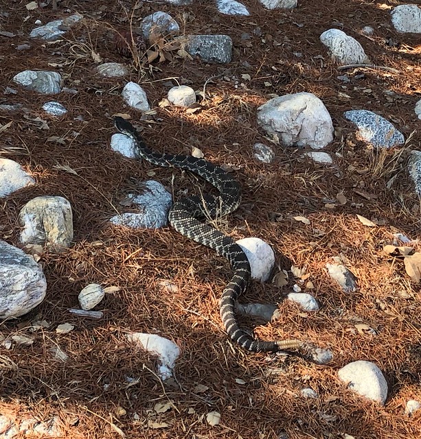
1. Suburban rattlesnake
This one is a little bit of a cheat, but it relates to a story that happened in September, so I'm counting it. I actually took this photo on August 25th and also blogged about it. But that's not the end of the story. You see, I love snakes. I'd much rather encounter any kind of snake than what they eat, which is mostly rodents. Now, don't get me wrong, there are plenty of rodents that are very cute and fun to see in nature (squirrels and rabbits come to mind), but anything that will control the rat and mouse population in my mind is a very good thing.
This is where this story takes a different course, because a week later in the first week of September, I spotted this same snake, but it was 10 feet below me in a drainage canal. This wasn't really a very good thing, because unless it was able to find some way out, the snake was going to probably die prematurely. I thought the only way this snake was going to escape was for someone to throw a large branch that it could then crawl up on and get out of the drainage canal. (First off, let non-California readers know that drainage canals here mean flood control. They are normally dry except during the rainy months of December through March.) Dropping a branch into the canal wasn't going to be practical, so I resigned myself to the fact that the snake was probably going to die.

That is until about a week after that I was walking in the same area and noted a side drain that I knew led up into the spreading area below the dam that the main drainage canal serviced. Cool. That meant that the snake most probably got down there by that side drain which also meant that it could get back out of the canal the same way. Nature finds a way.
2. Ouch
First thing I have to say is getting old sucks. But it beats the alternative. Nature has dictated that aches and pains take longer to heal as you get older and you get mysterious maladies that for the life of you, you can't explain how it happened. I'd love to say I injured this while out hiking, like I fell getting to a great overlook and strained my knee. Perhaps I strained it while running a marathon, but those of you who know me well know that I don't run. I much prefer taking a much slower route everywhere when I'm on my feet. Nope, as best as I can tell, this happened as I turned to get out of my computer chair and I strained the right knee as I twisted on it. I've done the same maneuver countless number of times in the past and nothing has ever happened, yet this time, nature decided to tweek my knee, which in turn has really curtailed my outdoors walking for the past month.
The knee is getting better, but it's definitely not 100%. Last week was the first week since the injury that my FitBit has registered three days in a row of 10,000 steps or more, so I view this as a major accomplishment. I'm taking it easy because I don't want this to become a longtime problem. I have things to do and places to go, one of them being Denver in the middle of next month and I want the knee to be good for that trip.
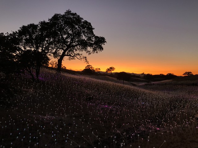
3. Sunset
The nice thing about nature, even though you may have limited mobility, it somehow comes to you. That's not the case with this next photo, but I think you get the gist of the statement. You don't have to be out in nature to appreciate a nice sunset. You could just step outside your front or back door and the sunset is right there.
This past weekend, I went on an overnight road trip to Paso Robles to view Bruce Munro's Field of Light at Sensorio. The website describes the Sensorio as being comprised of "an array of over 58,800 stemmed spheres lit by fiber-optics, gently illuminating the landscape in subtle blooms of morphing color that describe the undulating landscape." My daughter and son-in-law went there earlier at my suggestion and they both loved it. I was planning on going earlier in the month, but my injury set me back a couple of weeks. My daughter suggested that I get there a little before sunset. The lights of the artwork aren't as readily apparent, but the sunset that nature provided helped set the stage for what I was going to see later on.
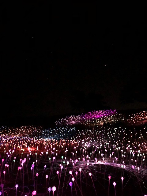
I've always been intrigued by temporary pieces of art like this, especially environmental art that attempts to blend the art into the landscape. I had just graduated high school when the artists Christo and Jeanne-Claude created their Running Fence project in Northern California. I didn't go see it though it was but a half day's drive from where I was living at the time and I regret not going to see it. When they created their Umbrella Project for Southern California and Japan, I made it a point to get out there and see it, at least the California edition of it. It was wonderful. And I also know that art is a form of beauty that is in the eye of the beholder. Some people will look at it and think, "really?" For me, I love environmental art such as this, so Sensorio was right up my alley and I made it a point to getting up here to see it.
4. Saturn and Jupiter
Nature is not limited to what is on the earth, but also what's in the sky, even to things that we can't even see. While at Sensorio, the night sky was also on full display. Had I gotten there a little bit earlier, I might have gotten a quick glimpse of Venus and a small crescent moon, both of which were preceding the sun through the sky. Once the skies became really dark, as I walked through the field of Sensorio, I was also treated to Saturn and Jupiter. For those of you non-astronomers, Saturn is the fainter white dot in the upper left, while Jupiter is the much brighter white dot to the right and downward from Saturn. Both planets can be seen very easily in the night sky right now and I felt the two planets viewed above the field of lights was just nature trying to enhance the human-made artwork.
I ended up walking through the fields on the paths for a little over two hours and these two photos are just the tip of the iceberg of the ones I took. I'm still going through all of my shots and processing them. I suspect that in the near future, I'll have an entire blog entry dedicated to the field of lights, so stay tuned.
5. Pelicans on a sea stack
As I made my way back home the next day from Paso Robles, I stopped along the way several times to take in the sights and to do a little geocaching. This particular spot was where there was an earth cache. Earth caches are virtual caches which don't have a physical container. You have to answer geology related questions after viewing the area and reading about the area on the earth cache page.
This particular earth cache dealt with some sea stacks that are just off the coast near Pismo Beach, California. The geology of how these are created is very interesting and I really enjoyed doing this particular earth cache. Once again, geocaching brought me to a place that I might not have visited were it not for this silly hobby that I so enjoy. Most likely, I would have barreled down the freeway at top speed, looked at the ocean as I drove by, but never really stop and appreciate how nature fashions the shoreline like it does. The topper of it all were all of the pelicans that use the stacks as a roosting area. As you can see, there were scores of the birds. The earth cache page also says you can see cormorants and California Gulls on the rocks. I did not see any cormorants, but there was at least one gull who had chosen to roost on the fence next to the bluff where this photo was taken. That gull must have been well fed by humans in the past, because it had no fear of me whatsoever. I believe that I could have pet it if I'd wanted to, but I resisted that urge.
And there you have it. These are my interpretations of the them for this month of Nature. Please check out P.J.'s for his interpretation of the theme for this month. At the bottom of that page, there will be links to others who have participated in this monthly challenge. As always, please leave a comment here. I try to respond back in a timely fashion. I promise, I won't bite.
This is a geocaching blog, so if you're not into geocaching, you can probably skip this one right now. But if you enjoy my geocaching rambles, then you'll probably want to continue reading.
Following my night of camping at Cedar Breaks National Monument, I headed to Potters Pond in central Utah. Most of you who are into geocaching know that there are challenge caches out there for all sorts of things. Some are silly and others are rather challenging, for want of a better word.
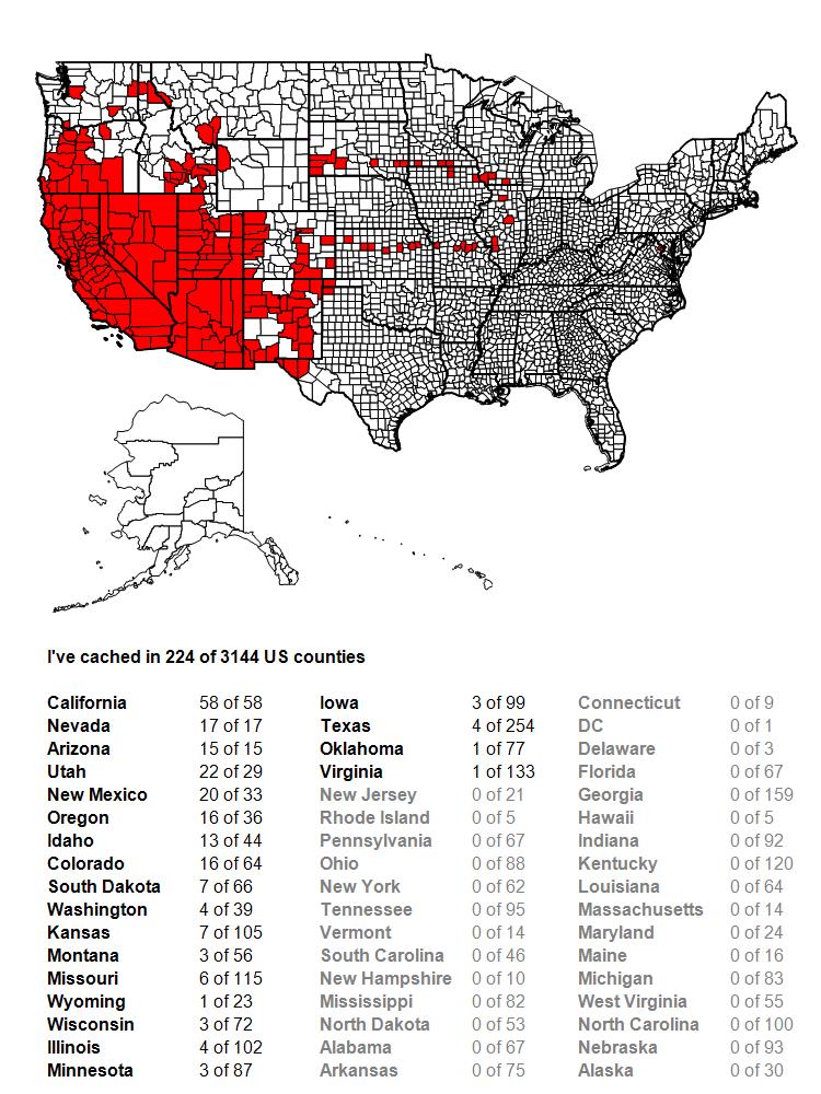
Challenge caches are just that; they challenge you to do something in order to claim the find on the challenge cache. They can be as simple as find 25 geocaches, to finding a geocache that was hidden in every month since geocaching has been around, to all sorts of other options in between. I worked toward three different challenges on the second day as I drove to Potters Pond. One was for 100 contiguous county finds. Before this day, I'd found geocaches in 95 contiguous counties, so obviously, I needed 5 more counties connected to the ones I'd already found geocaches in to get me to 100. By the end of the day, I'd be up to slightly over 100, so mission accomplished and by the end of the trip, I'd be up to 117 contiguous counties.
The second challenge I was working on was to find more caches above 8000 feet. This particular challenge, I haven't found yet, but it's on my "to do" list. It's located up in the Sierra Nevada, above 8000 feet obviously, but it would also mean a hike along the Pacific Crest Trail, something that I want to do more of anyway. It's on the back burner, but as long as I'm at altitude, I might as well get as many as possible. I'm not sure how many I have at the moment, because it's more difficult to check (I'm on a Mac, so I don't have ready access to GSAK, a Windows based program for geocaching), but I found 12, possibly 13 more that were at over 8000 feet, so I added to the list.

The third challenge was getting Potters Pond. For the uninitiated in geocaching, the Jasmer Challenge challenges you to find a geocache that was placed in every month since geocaching started, way back in May 2000. Yes, this means you have to find a cache that was hidden in May 2000, plus June 2000, etc., all the way to the current month. Before this trip, I needed 3 more months, June, July and August 2000. On my road trip two summers ago, I'd found the oldest geocache in the world, Mingo, so May 2000 was covered. I'm also fortunate, since I started geocaching in March 2001, there were some of those older caches still around. In fact, my very first cache find was hidden in December 2000, so I've never had to worry about that particular month.
August 2000 has always been kind of problematic, since there are only 3 geocaches in the entire United States that are still around that were hidden in that month, one in upper Michigan, one outside of Atlanta, Georgia and Potters Pond. Potters Pond is also at altitude and under snow for probably half the year or so, so it's definitely a summertime grab. So that became the focus of the day.
Potters Pond is located along a trail near a campground. The tricky part is finding the correct trail. Once you find the trail, it's a pretty easy maneuver to get back and find the cache. I did my homework and when I arrived at the campground, I hiked back, found the correct trail, found a couple of other caches along the way, then walked back into the woods and eventually claimed the prize. The one photo of the actual pond is what I have as proof that I was there, mainly because the mosquitos that day were horrendous. As long as you kept moving, you were okay, but as soon as you stopped, they descended, as if they were vultures coming across road kill, even biting through my shirt. Needless to say, I traded travel bugs quickly, signed the log quickly, replaced the cache quickly and got moving again. But, I now have August 2000 off of my list and I'm only a road trip to northern Oregon away from completing the Jasmer, as there are caches still around up there from June and July 2000.
If you want hints on how to get there, which roads to take, don't hesitate to ask someone who's already found it. Bushwhacking would take a lot out of you. The trail leads right to it. I listened and learned.
When I started my first road trip of 2019, I knew my first stop would be Cedar Breaks National Monument, located just east of Cedar City, Utah. There were a couple of reasons for camping here, one that it's usually very uncrowded and so you pretty much have the pick of campgrounds. A second reasons was there was an earth cache in the park that I wanted to find so I could complete a geocaching challenge of finding an earth cache in four different states on the same day. As it was, I'd already found an earth cache south of where I was, but camping there still made sense as it was a good jumping off point for my next day's adventures.
I've camped in Cedar Breaks previously and it really is a good jumping off point for various spots around Utah that we have wanted to explore. For those of you who aren't familiar with Cedar Breaks, I think I can best describe it as a miniature version of Bryce Canyon National Park. It doesn't attract the visitors that Bryce Canyon does, mainly because there's not nearly as much to do there. The features in the park are nice, but you can't hike down into them the way you can at Bryce Canyon and that's by far and away the best feature, to be able to hike among them. And so it becomes more of a jumping off place. You walk the rim, you look down on the hoodoos below you and then you move on.
But, apparently, the word is out that this is a nice place to visit. When I got there around 5:30 in the evening, the campground was pretty much filled, so I didn't have a great deal of choice in spot, but I was still able to snag a nice spot for the night. Once I had camp set up and dinner in my belly, I decided to head out on a hike because I still had plenty of daylight.
Because I've been there previously, I decided to take a trail I hadn't explored before which was the Alpine Pond Trail which led off of the Chessman Ridge Overlook and walked along the eastern edge of the amphitheater of Cedar Breaks, leading to an alpine lake at 10,400 feet of elevation.
It was a pretty much level hike because most of the park where visitors are is all above 10,000 feet, but the air was thin. I probably overdid it a little bit on this hike for a couple of reasons. One, I was running out of daylight and I wanted to get some good shots while there was still light and two, which is in hindsight, I was a little bit dehydrated after driving all day. I definitely had not kept up a sufficient amount of fluids in my system that day and I was going to pay for it later with a little bit of altitude sickness.
Another reason I decided to take the trail was also to escape some very loud college students who decided to park themselves out on Chessman Overlook and scream at each other from 3 feet away or so. Seriously? You're 3 feet away from each other and you feel the need to scream? I can already hear my daughter in my head saying, "GET OFF MY LAWN." It didn't really matter, because I escaped the noise by hiking away from it, and when I came back, they were gone and I had the overlook to myself.
The hike was very peaceful and I had lots of opportunities to see the amphitheater through the trees. There were lots of wildflowers alongside the trail: Scarlet paintbrush, Colorado Columbine and Shootingstar being the most abundant that I saw. The trail followed a creek that flowed down into the breaks and eventually led to the pond. I followed that creek to the alpine pond where I was rewarded with some very nice reflections of the sun glowing off of the trees along the opposite bank. I lingered there taking several different photos with different exposures hoping that one of them would turn out decently, then decided to take the same trail back to the overlook which was a very good decision.

Had I taken the trail in a loop instead of an up and back, I would have missed the sunset on the rim. After enjoying the sunset and taking a multitude of shots, I drove back to my campground and settled down for the night, hoping to have a restful night sleep. Unfortunately, the high altitude did me in that night and I didn't sleep very well due to headache and upset stomach. Fortunately, fluids and food the next morning, plus a drop in elevation leaving the monument helped me recover rapidly. In the past, I've always slept well at Cedar Breaks and the only thing I can attribute all of this too was my intake of fluids during the drive up there from Southern California. I didn't have any problem the rest of the trip, even though I was at altitude for most of the trip. I made sure I was properly hydrated and was probably acclimated to the altitude as well.
In the morning, I walked along the rim, taking photographs, checking out the visitors center when it opened and just enjoying the sights the park had to offer before I hit the road again. I could hear Utah's oldest geocache calling my name.
To be continued.....
August has been a very enjoyable month. For the first time in 20 years or so, I didn't go back to work in August. Yeah, school used to start in September, but it's been opening up in August for quite a number of years. In fact, today is my youngest's 24th birthday. His due date was September 12th. I was concerned at the time, because that was the first day of school for me. Now, school begins the first week in August. But as many of my friends know, it's not my circus, not my monkeys anymore because I retired at the end of the last school year in May.
P.J. has his monthly blog challenge and this month's challenge, for the month of August was The Written Word. At first, I thought I wouldn't be able to put anything together, photographically for this particular month, but when I look back over my photos I took this month, I realized that I have quite a selection from which to choose. And so it goes.
August, as noted above, was very different this year. I actually spent time in five different states, so I've decided that each photo this month, not only should convey the theme of the written word, but should also represent each one of the different states that I spent time in this month. I've posted on Facebook photos of signs leading into National Park sites that I visited and said, "I'm a National Park Geek." And someone joshingly pointed out that maybe I was a sign geek. Well, that's possible. I love how signs sometimes give you so much information with very little words.
1. Hiking

I like to hike, always have, always will. I spent the month hiking a lot. In fact, I spent a large portion of the summer hiking. One of my favorite hikes is a 5 mile loop in the Claremont Wilderness Park, a park that I didn't know even existed back in 2001. That was the park that started me on geocaching, mainly because when I discovered geocaching, this park was where the closest geocache was hidden from my house at the time. It was literally 7 miles away and a half mile hike. I bought a GPS, took the boys out that Saturday and we found the cache. We didn't walk the entire loop that time and there have been many times in the past I have not hiked the loop, mainly because I was out of shape at the time. I'm not sure I'm in great shape now, but I do know that I'm in much better shape than I was back in 2001. This is a good thing because I want to enjoy my retirement for as long as possible and being in good shape will help me achieve this goal. So the written word on the sign post either tells me how far I've gone, or how far I still need to go to complete the loop. In this case, I took it after I'd already hiked 4 and a half miles. This was taken in California.
2. Road trip
In the middle of the month, I took a week-long road trip through four states, just so I could feel that my routine was a little bit different for this month as opposed to most Augusts over the past years. I grabbed Interstate 15 and took it north, traveling through Nevada and then into Arizona where the second photo was taken. I love the color in this photo and amount of information.
At least 7 different signs tell you a bunch of information that you need to know as you barrel your way into Arizona at 75 mph. And no, I didn't take this photo while flying down the Interstate. I actually did pull over and take the shot, although now that I look at it, I wonder if that would be considered emergency parking?
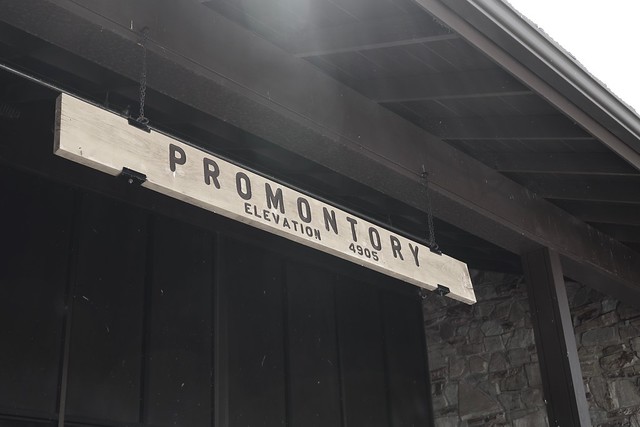
3. The Golden Spike
That first day, I eventually ended up in Utah. A couple of days later, I decided that my next point of destination would be Golden Spike National Historic Site, the site where the trans-continental railroad joined the country together in May, 1869. The country would never be the same. Promontory, Utah was a boom town, which grew up at the site of the Golden Spike, but soon died when the railroads moved operations to a more profitable route. I spent time time at the site watching the engines move up and down the tracks and I also got a nice hike in along the old railroad rights of way. I say ways, because the two railroad companies literally created grades for the two lines that went by each other for 230 miles or so, mainly because they hadn't agreed upon a meeting place and they were getting paid by the mile by the United States Government. When they finally agreed upon a meeting place that at Promontory, the grading stopped and they worked toward that point. I also learned that the original golden spike is nowhere near Utah anymore.
Because the Union Pacific Railroad abandoned these lines first, the Central Pacific ended up taking over this part of the rail lines and so ended up in possession of the golden spike, which is now located at Stanford University. I guess I need to go to Stanford to complete this trip.
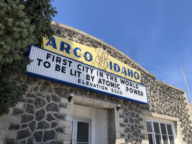
4. Atomic Power
After Golden Spike, I ended up in Idaho for my next adventure. I was going to be camping at Craters of the Moon National Monument. Taking back roads to the northeast of the monument, I ended up driving through the small town of Arco, Idaho. Now, when you think of Idaho, do you think of atomic power? Probably not and although I was peripherally aware of Idaho's contribution to atomic power, I was not aware that Arco was the first city lit by electricity via atomic power, something that the town, obviously, is very proud of. This is one of the reasons I love road trips like this. You stumble upon all sorts of interesting tidbits of information that you might have missed if you just flew into an area with one destination in mind.
5. Extra Terrestrials
After camping at Craters of the Moon and also Great Basin National Park, I decided to come home. But, as a geocacher, I had to stop here. This last shot I found at a gift shop at the beginning of the E.T. Highway which runs along SR-375 in Nevada just east of Hwy 93. It's become somewhat of a Mecca for geocachers around the world, because it's one of the major "Power Trails" in existence. A power trail is a route set up by geocachers where there are a lot of geocaches along a specific route. Geocaches are not supposed to be closer than 528 feet apart, so a power trail typically has one every 10th of a mile for a long distance, in this case, the E.T. Highway has a geocache hidden every tenth of a mile for 200 miles. Yeah, the math works out to 2000 geocaches. I found the first one in the series and then turned around and continued on my way home. At least now I can say I've geocached on the E.T. Highway. Whether I ever get back to it or not is an entirely different story. I have, however, signed a challenge cache near the beginning of the E.T. Highway, which challenges me to find 1000 geocaches in the state of Nevada. With only 76 finds in the state, I have a ways to go and this power trail would help me complete that challenge.
So that completes my interpretation of P.J.'s month blog challenge, the Written Word. Please click on the link and check out other bloggers' interpretations of the theme for this month.